All Activity
- Past hour
-
Lots of cold upnthere in SE Canada. Beware
-
I wish it wasn’t H cubed and Rufus dropping 2-4 . Tough to rely on those POS
-
24° with freezing fog. Day 74 with snow cover, 42 consecutive days and counting. Looking at the long range it looks like 100 days of snow cover will not happen this year, but this weekend should get me that .1 inch to get me over 60 inches for the season. Would like to get over 70 inches for the first time since 2017/18 from the long range it looks like that may be in jeopardy, for now at least. Late March and early April have produced plenty of late season snows here so I'll wait and see.
-

Winter 2025-26 Medium/Long Range Discussion
A-L-E-K replied to michsnowfreak's topic in Lakes/Ohio Valley
Zzzzz -

Is we back? February discussion thread
Damage In Tolland replied to mahk_webstah's topic in New England
Nice to see today trend with more clouds .. less sun -
I wonder if we get our normal fruit blossom freeze that kills the peach, cherry, and apple blossoms every spring. I noticed even up on the Tug Hill that temps might hit 70 next week. 80 here. Rip winter 2026. It was a good run.
-
I think it’s possible that March might be the best month this year…. Maybe towards the end of May into June for your traditional areas. Nina to neutral is gonna choke the troughs off. But obviously severe doesn’t need the perfect pattern, just the perfect day. .
-
I know GFS has a few inches going to rain later this week, but I mean something that would be decently frozen. Right now it just looks mild overall.
- Today
-
I don’t mind late season freezes especially to knock the bugs back but whatever we get this year is going to be damaging considering the next two weeks of +15-25 temps
-
Extremely boring and mild starting later this week. Too bad we can’t squeeze in one more.
-
Whole thing is becoming C-1” on guidance.
-
Looks like Meso’s like the Pike Region tomorrow, NAM not so much.
-
Let's try to bring 1998 further south

-
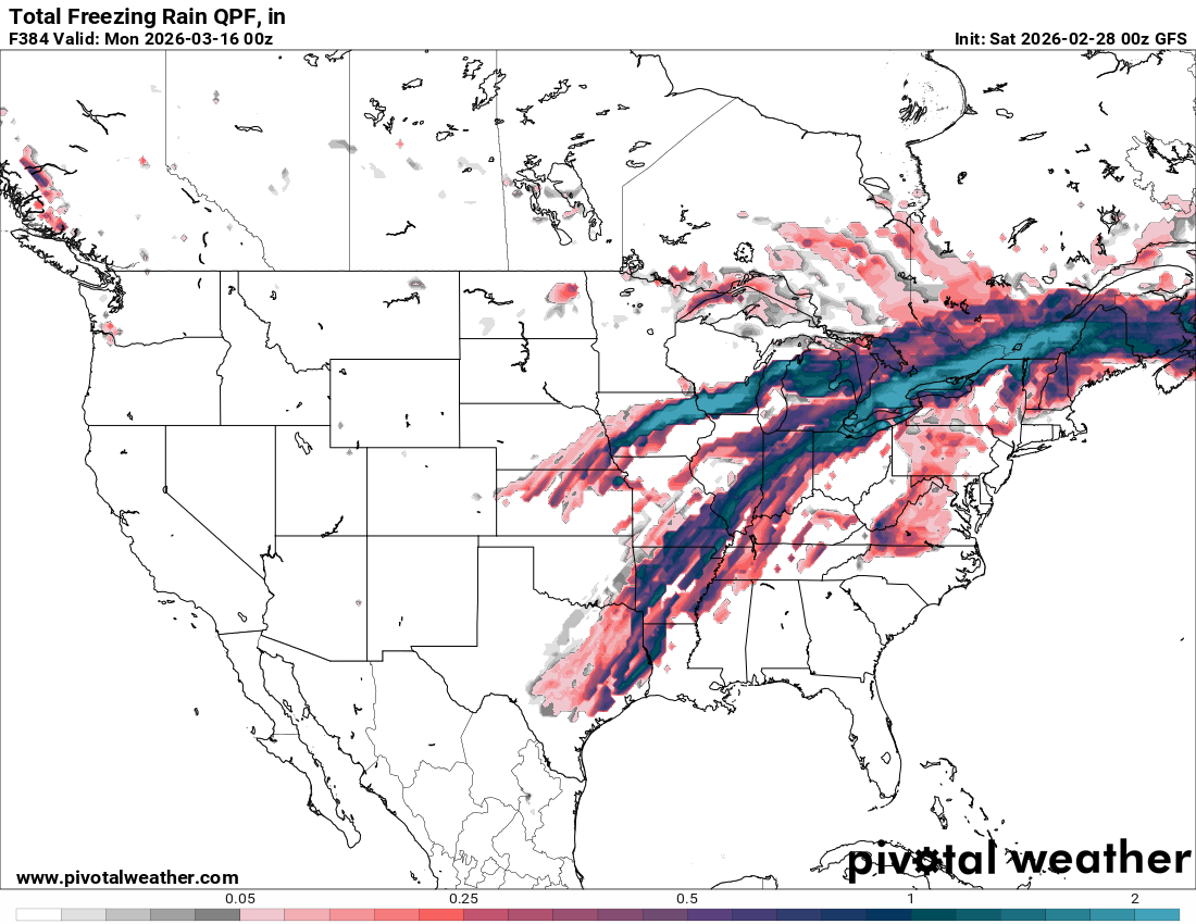
NAM and RGEM look like they would pretty icy beyond hr 84
-
Aliens
-
Nice. 1888 was just based on NESIS and COOP data, it's nothing special just had to go off whatever is out there since it's so incredibly old. We were still riding around on horses, wild to think about. Everything was done manually in Photoshop and exported as a jpg. I have that and the original psd file for everything, almost 2k files of each. So nothing is vector based. Thanks for all your help over the years.
-

Late February/Early March 2026 Mid-Long Range
stormtracker replied to WxUSAF's topic in Mid Atlantic
I hope all of Chuck's plantings are destroyed by frost or freeze -
B÷ winter. Final
-
Driving through the early January 2003 event just south of Worcester on 146 around midnight was some of the most difficult driving of my life. March 6, 2001 around New Haven around midnight on 95 was epic as well. December 23, 1997 around noontime 10 miles N of Dedham was also epic.
-
Cat 2 on NESIS and Cat 3 on RSI, I think the latter is a far better representation of this storm’s magnitude despite not quite hitting all of the population centers as hard as it could’ve, like some in the past (PDII, Jan 1996, Feb 1983, etc). If the core Boston area had gotten 2 feet instead of 15”, it’d easily be a Cat 4 on the RSI.
-
Great call
-
lol...what's going on here?
-
you paid pre-tariff prices. now you only get 2 months and change.
-
somewhat political, but we just launched strikes against Iran. Looks like they were designed to take out Iranian leadership.
-

"Don’t do it" 2026 Blizzard obs, updates and pictures.
andyhb replied to Ginx snewx's topic in New England
This storm has been rated a high end Cat 3 on the RSI scale for the Northeast, which to me seems like a fair ranking considering it didn’t quite bullseye most of the population centers with the heaviest amounts, missed DC/Baltimore entirely, and was fairly confined to the coast. However, it produced historic or near historic snowfall amounts over the area it did strongly affect and did drop 20+” on most of the NYC metro. Way better than NESIS IMO.