All Activity
- Past hour
-
I think this warm up is a bit different than the head fake we saw modeled for early December. It’s coming, and it’s pretty obvious by every parameter except the MJO. The question is how long? Modeling seems to show the Scandinavian ridge migrating into a -NAO set up and the EPO going negative as well. My bet is by new years we’re back in business but I may be wrong. I think Jan could be cold before we enso rears its ugly head in Feb.
-

Central PA Winter 25/26 Discussion and Obs
Mount Joy Snowman replied to MAG5035's topic in Upstate New York/Pennsylvania
Great post and so true. I would emphasize that the first half or three quarters of the pack goes a LOT quicker than the last part due to heavy compaction resulting from lower density. I've seen countless times where that last 4-6" hangs on way longer than you'd expect due to the extremely dense icy nature of the pack. As you alluded to, sleet mixed in helps greatly but also the pack itself creates its own icy center due to the daily melt and refreeze cycle. I know you know all this; I just love this topic ha. -

2025-2026 ENSO
brooklynwx99 replied to 40/70 Benchmark's topic in Weather Forecasting and Discussion
you know, some of you keep giving that guy a platform by breathlessly posting about him. we know he sucks -

December 2025 regional war/obs/disco thread
WinterWolf replied to Torch Tiger's topic in New England
We don’t need brutal cold either going forward…climo will be kicking in, and normal temps will be sufficient too. -

December 14th - Snow showers or Plowable snow?
CoastalWx replied to Sey-Mour Snow's topic in New England
Nope -

December 2025 regional war/obs/disco thread
Great Snow 1717 replied to Torch Tiger's topic in New England
Nope.... -
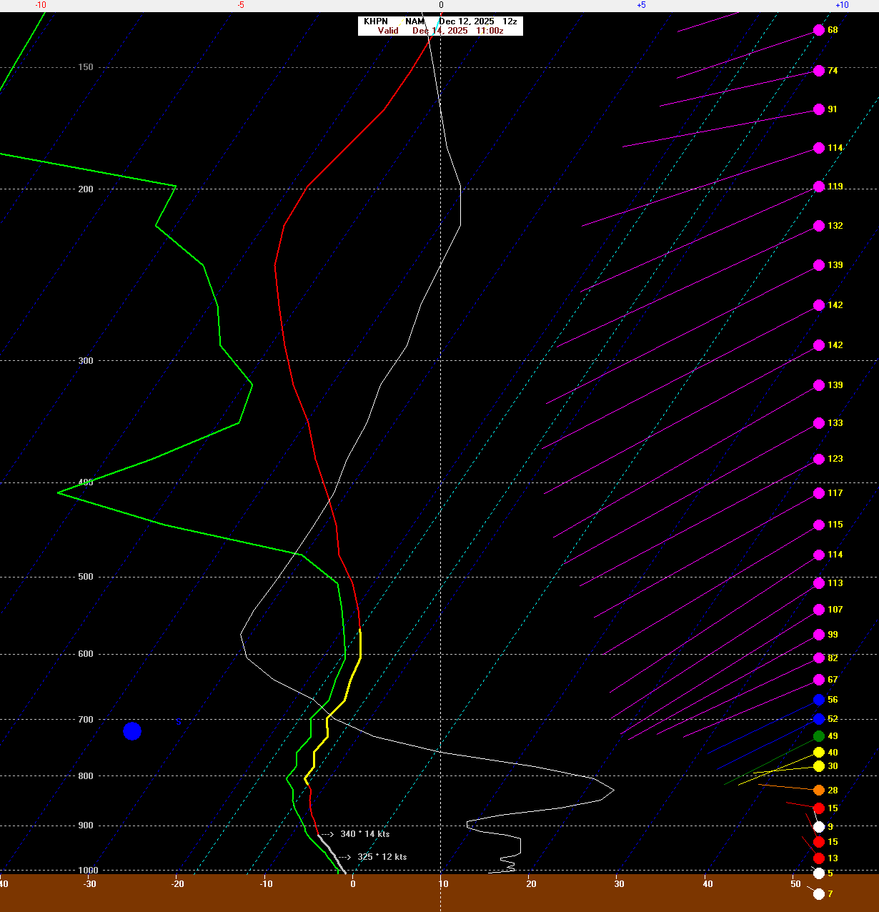
Also - get 0.25" of liquid with this kind of sounding for New Haven and you can squeeze out 4" of snow or something.
-

Minor snow possible sunday 12/14/25
Stormlover74 replied to WeatherGeek2025's topic in New York City Metro
Icon is dusting to 2". 3+ to the south -

December 2025 regional war/obs/disco thread
Damage In Tolland replied to Torch Tiger's topic in New England
Golden shovels, showers.. you name it -
2015-2016 was a super El Niño like 1982-1983 and both years had blockbuster snowstorms during the 2nd half of winter. This was the case since El Niños usually start out slow snd have their snowiest periods later. So we often can’t use December El Niños as a marker for the rest of the season. But sometimes in the cases like 2002-2003 and 2009-2010 El Niños, December is so snowy that we get epic follow up snows during the February El Niño prime time. So in those cases a December forecast for a very snowy season would have worked out.
-
December 2025 regional war/obs/disco thread
Damage In Tolland replied to Torch Tiger's topic in New England
The hope of Hammer ! -

Minor snow possible sunday 12/14/25
WeatherGeek2025 replied to WeatherGeek2025's topic in New York City Metro
RGEM is 3-5 it looks best right now -
Where do I sign for that. Unfortunately it's the only model really showing much for Frederick/ Hagerstown
-

December 2025 regional war/obs/disco thread
SouthCoastMA replied to Torch Tiger's topic in New England
Hard to sit Maye in the playoffs. I have Maye and my opponent has Allen. Hoping they kinda wash each other out. -

December 14th - Snow showers or Plowable snow?
ORH_wxman replied to Sey-Mour Snow's topic in New England
Not buying Reggie -

12/14: Sunday funday? Will the south win again?
BlizzardNole replied to TSSN+'s topic in Mid Atlantic
This run fits our new climo with the favored S&E suburbs. My Calvert folks got like 2.5 times as much snow as me last winter and I expect that to continue. -
Indeed it does. Previous rgem runs had almost nothing. That said, you’re in a much better position than I am for this one.
-
It didn't last long, and radar does not look promising for much (if any) more, but it was fun to see fall for a few minutes. Mood flakes!
-

December 14th - Snow showers or Plowable snow?
TauntonBlizzard2013 replied to Sey-Mour Snow's topic in New England
Actually improved here. Looks like we’d get some form of CCB for a bit -

December 14th - Snow showers or Plowable snow?
Sey-Mour Snow replied to Sey-Mour Snow's topic in New England
Ya tossing reggie and 6z euro.. -

Saturday night/Sunday 12/13-12/14 Jawn
Newman replied to Ralph Wiggum's topic in Philadelphia Region
A couple things I'm interested in: 1. As we near this event, how do the mesos trend with the upper level jet and any small ticks in TPV placement to allow greater height rises (or worsening). 2. QPF trends on guidance, especially along the northwest edge of the precip shield. Latest RGEM stays wet for the Lehigh Valley (0.2-0.3" of precip), NAM much drier. 3. Post-storm, I'm curious what the SLRs end up being. The NAMs are the most aggressive (no surprise) in some solid omega within the DGZ and also 850mb fronto, but mostly along and south of I-95 once the storm starts to get going a bit. I'm curious to compare 10:1 and Kuchera model maps to reality. -
my grandparents were visiting from southern indianan and they had never seen snow like that.....an older woman told me her husband died shoveling the snow and she had to keep him the house for a few days as no one could get to her.....
-
December 14th - Snow showers or Plowable snow?
Sey-Mour Snow replied to Sey-Mour Snow's topic in New England
RRFS back to earth looks like Euro now, I think the Nam's have the right idea as they are a blend of EURO and GFS -

Minor snow possible sunday 12/14/25
jm1220 replied to WeatherGeek2025's topic in New York City Metro
I’m liking how consistent it’s been. Hopefully it has a clue. I don’t buy into the NAM flopping again, it needs to be put out of its misery. But hopefully we see other models bumping N a bit and becoming more aggressive. It’s still a setup where this is fast moving and the trough can squish it south and rush dry air in. That’s the problem the Hudson Valley and much of SNE has-this is all just moving too fast and can’t amp up in time with the trough pressing down. That also brings in dry air. I bet that area with under an inch has flurries to maybe a dusting because of virga-seen that here last winter with those DC to S NJ systems. -
And there’s even a chance at still another with the Arctic plunge coming in Sunday!