All Activity
- Past hour
-

2025-2026 New England Snow Recordkeeping Thread
Lava Rock replied to bristolri_wx's topic in New England
I don't think so. Astronomyenjoyer was able to log today's event and has "view only" permissions as does everyone else. Not sure how he got his entered. -
It’s also a matter of perspective. To me that’s a lot of snow in your pic. I’ve had that much in the entire winter only 3 times in the last 45 years (1/2025, 1/2018, and 12/1989). This area could easily not see that much again for decades.
-

Richmond Metro/Hampton Roads Area Discussion
chris624wx replied to RIC Airport's topic in Mid Atlantic
Jumping in to say I'm liking the trends to at least see maybe a dusting to a little more here in Southside HR. I'll take that for mid-December! -
All of VT and SLK for @WxWatcher007 ...Franklin County... Paul Smiths 3.0 in 0620 PM 12/02 Public Saranac Lake 6.2 N 2.7 in 0556 AM 12/03 COCORAHS ...Vermont... ...Addison County... Hancock 0.3 S 5.5 in 0700 AM 12/03 COCORAHS Starksboro 4.4 ENE 5.0 in 0900 AM 12/03 COCORAHS Bristol 4.6 in 0645 AM 12/03 COOP Shoreham 3.5 NNE 4.5 in 0800 AM 12/03 COCORAHS Orwell 1.2 WNW 4.2 in 0700 AM 12/03 COCORAHS 0.5 NE South Lincoln 4.2 in 0700 AM 12/03 COOP 1 N Ferrisburg 4.0 in 0411 PM 12/02 Public Monkton 4.0 in 0512 PM 12/02 Public New Haven 2.4 SE 3.8 in 0800 AM 12/03 COCORAHS Middlebury 0.3 N 3.5 in 0700 AM 12/03 COCORAHS ...Caledonia County... 1 ENE Lyndonville 8.6 in 0832 PM 12/02 Public Wells River 2.1 WNW 8.6 in 0700 AM 12/03 COCORAHS East Saint Johnsbury 8.0 in 0805 PM 12/02 Public Groton 8.0 in 0934 AM 12/03 Public St. Johnsbury 0.4 N 7.1 in 0700 AM 12/03 COCORAHS 1 SW Saint Johnsbury 6.5 in 0830 PM 12/02 Cocorahs 1 WNW Danville 6.5 in 0941 PM 12/02 Public Lyndonville 6.0 in 0424 PM 12/02 Public 1 SSE Groton 6.0 in 0701 PM 12/02 Public Danville 0.4 N 6.0 in 0800 AM 12/03 COCORAHS 2 NE East Lyndon 6.0 in 0918 AM 12/03 Public Wheelock 1.6 S 5.7 in 0700 AM 12/03 COCORAHS 1 SW Sutton 4.6 in 0709 PM 12/02 CO-OP Observer West Burke 4.5 in 0700 AM 12/03 Public Lyndonville 1.1 W 4.5 in 0730 AM 12/03 COCORAHS Sutton 4.4 in 0700 AM 12/03 COOP West Burke 4.0 in 0444 PM 12/02 Public ...Chittenden County... Underhill 4.4 NNE 5.5 in 0700 AM 12/03 COCORAHS 3 WNW Underhill Center 5.3 in 0500 PM 12/02 Public 1 NW Essex Junction 4.9 in 0923 PM 12/02 NWS Employee Huntington 6.5 S 4.8 in 0800 AM 12/03 COCORAHS 1 NNE Colchester 4.7 in 0344 PM 12/02 NWS Employee Williston 0.2 WSW 4.5 in 0700 AM 12/03 COCORAHS Underhill 5.1 NNE 4.5 in 0700 AM 12/03 COCORAHS 2 NNW Burlington 4.5 in 0711 AM 12/03 NWS Employee South Burlington 2.4 NNE 4.5 in 0757 AM 12/03 COCORAHS 2 NW Underhill Center 4.2 in 0410 PM 12/02 Public Huntington 1.1 E 4.2 in 0700 AM 12/03 COCORAHS 1 ESE Charlotte 4.2 in 0845 AM 12/03 Public Jericho 4.0 in 0820 PM 12/02 Public Nashville 1 E 4.0 in 0645 AM 12/03 COOP Burlington 3.8 NW 4.0 in 0800 AM 12/03 COCORAHS 1 NNW Burlington 3.7 in 0430 PM 12/02 NWS Employee 2 SE Jericho 3.6 in 0651 AM 12/03 Public Hinesburg 0.9 N 3.6 in 0716 AM 12/03 COCORAHS Shelburne 0.5 ENE 3.5 in 0700 AM 12/03 COCORAHS Hinesburg 1.5 SW 3.5 in 0700 AM 12/03 COCORAHS Underhill 3.6 ESE 3.5 in 0730 AM 12/03 COCORAHS South Burlington 2.6 SSW 3.5 in 0800 AM 12/03 COCORAHS 1 WNW Jericho 3.2 in 0509 PM 12/02 NWS Employee 2 SE Winooski 3.1 in 0508 PM 12/02 Official NWS Obs Charlotte 3.0 in 0425 PM 12/02 COOP Charlotte 1.8 SW 3.0 in 0700 AM 12/03 COCORAHS ...Essex County... Lunenburg 2.3 NNW 8.0 in 0500 AM 12/03 COCORAHS Maidstone State Park 7.9 in 0807 AM 12/03 Public Averill 4.5 in 0600 PM 12/02 COOP Island Pond 2.0 in 0830 AM 12/03 COOP ...Franklin County... 2 E Fairfax 3.8 in 0351 PM 12/02 Public Fairfax 4.9 WNW 3.3 in 0900 AM 12/03 COCORAHS Enosburg Falls 2.8 in 0457 AM 12/03 COOP Swanton 2.3 in 0617 PM 12/02 NWS Employee Swanton 0.5 NNE 2.3 in 0700 AM 12/03 COCORAHS Montgomery 4.1 ESE 1.7 in 0700 AM 12/03 COCORAHS Enosburg Falls 2.5 N 1.6 in 0700 AM 12/03 COCORAHS ...Grand Isle County... 1 NE South Hero 3.8 in 0754 PM 12/02 Public ...Lamoille County... 1 SSE Smugglers Notch 6.0 in 0423 PM 12/02 Trained Spotter 2 NE Smugglers Notch 5.8 in 0112 PM 12/02 Public Jeffersonville 1.3 SSW 5.5 in 0700 AM 12/03 COCORAHS 1 NNW Morrisville 4.2 in 0518 PM 12/02 Public Johnson 2 N 4.0 in 0710 AM 12/03 COOP 2.5 N Smugglers Notch 4.0 in 0730 AM 12/03 COOP Stowe 0.2 SW 3.9 in 0730 AM 12/03 COCORAHS ...Orange County... 3 NNW Strafford 8.5 in 0727 AM 12/03 Public East Randolph 7.0 in 0943 PM 12/02 Public Braintree 2.8 SW 7.0 in 0700 AM 12/03 COCORAHS 1.5 E Corinth Corners 6.7 in 0650 AM 12/03 COOP Bradford 2.2 NNW 6.0 in 0500 AM 12/03 COCORAHS 1 NNE Tunbridge 5.5 in 0430 PM 12/02 Public 1 W Newbury 5.4 in 0600 PM 12/02 Public 1 ENE Chelsea 5.0 in 0546 PM 12/02 Public 2 SE Strafford 4.8 in 0630 AM 12/03 COCORAHS Williamstown 3.0 WSW 4.7 in 0700 AM 12/03 COCORAHS West Fairlee 1.8 ENE 4.5 in 0700 AM 12/03 COCORAHS 1 W Fairlee 4.0 in 0848 AM 12/03 Public ...Orleans County... Morgan 6.7 SE 6.0 in 0600 AM 12/03 COCORAHS Greensboro 3.9 NNE 4.9 in 0730 AM 12/03 COCORAHS 3 ESE East Craftsbury 4.4 in 0445 PM 12/02 Cocorahs 1 NNW Glover 4.3 in 0704 PM 12/02 Trained Spotter Brownington 4.7 ESE 4.0 in 0800 AM 12/03 COCORAHS Craftsbury 1.6 SSW 4.0 in 0900 AM 12/03 COCORAHS Greensboro 2.1 NNW 3.8 in 0700 AM 12/03 COCORAHS Craftsbury Common 3.7 in 0700 AM 12/03 COCORAHS Albany 3.3 in 0400 PM 12/02 Public Derby Line 2.5 in 1035 PM 12/02 Public Derby Line 1.9 W 2.5 in 0630 AM 12/03 COCORAHS Westfield 0.8 WNW 2.0 in 0700 AM 12/03 COCORAHS ...Rutland County... 3 W Pawlet 8.0 in 0523 PM 12/02 Public 3 NW Pawlet 7.0 in 0937 AM 12/03 Public 1 NNW South Wallingford 6.7 in 0830 PM 12/02 Cocorahs Wallingford 2.7 SSW 6.7 in 0645 AM 12/03 COCORAHS Rutland 1.2 N 5.7 in 0700 AM 12/03 COCORAHS 1 N Rutland 5.7 in 0700 AM 12/03 COOP 1 ESE Brandon 5.5 in 0649 PM 12/02 Public Shrewsbury 0.8 W 5.5 in 0630 AM 12/03 COCORAHS West Rutland 0.9 SSE 5.5 in 0800 AM 12/03 COCORAHS West Rutland 1.2 N 5.4 in 0615 AM 12/03 COCORAHS ...Washington County... 3 NNE Waitsfield 6.5 in 0604 PM 12/02 Public 1 SE Websterville 6.4 in 0722 AM 12/03 NWS Employee Cabot 6.0 in 0545 PM 12/02 Public Plainfield 1 ESE 6.0 in 0700 AM 12/03 COOP Cabot 3.9 ENE 6.0 in 0900 AM 12/03 COCORAHS 1 W East Barre 5.8 in 0956 PM 12/02 NWS Employee Barre 5.5 in 0954 AM 12/03 Public Northfield 1.5 N 5.4 in 0700 AM 12/03 COCORAHS 2 NNW Waitsfield 5.3 in 0429 PM 12/02 Public East Calais 1.5 SW 5.0 in 0700 AM 12/03 COCORAHS Warren 2.8 E 5.0 in 0700 AM 12/03 COCORAHS East Montpelier 4.8 in 0730 AM 12/03 COCORAHS Waterbury 3.0 NW 4.5 in 0600 AM 12/03 COCORAHS 1.6 W Worcester 4.2 in 0700 AM 12/03 COOP Woodbury 3.4 NNW 4.0 in 0700 AM 12/03 COCORAHS Moretown 2.1 N 4.0 in 0800 AM 12/03 COCORAHS ...Windsor County... 1 WSW Rochester 7.3 in 0625 AM 12/03 Public 1 NNE Pomfret 7.2 in 1155 PM 12/02 Public Rochester 1.7 NNE 7.1 in 0500 AM 12/03 COCORAHS Proctorsville 0.3 NNE 7.1 in 0700 AM 12/03 COCORAHS Chester 3.0 WSW 7.1 in 0700 AM 12/03 COCORAHS 1 NNW Springfield 7.0 in 0555 PM 12/02 Public Andover 2.5 NW 6.2 in 0700 AM 12/03 COCORAHS 4 NE West Hartford 6.1 in 0639 AM 12/03 Public Ludlow 3.4 S 6.1 in 0700 AM 12/03 COCORAHS 3 S Ludlow 6.1 in 0751 AM 12/03 Trained Spotter Barnard 2.7 NW 6.0 in 0700 AM 12/03 COCORAHS South Royalton 5.0 in 1010 PM 12/02 Public 3 NE West Hartford 4.9 in 0900 PM 12/02 Public 0.6 E Woodstock 4.6 in 0800 AM 12/03 COOP North Hartland 1 NNE 4.0 in 0700 AM 12/03 COOP ..Bennington County... Manchester Center 0.9 NE 11.5 in 0730 AM 12/03 COCORAHS 1 WSW Manchester Center 10.6 in 0932 PM 12/02 Trained Spotter 5 SSW Arlington 8.7 in 0400 PM 12/02 Shaftsbury 0.4 WNW 8.7 in 0400 PM 12/02 COCORAHS 5 NNW Londonderry 8.5 in 0946 PM 12/02 Manchester 1.8 SSW 8.3 in 0700 AM 12/03 COCORAHS 1 ESE Manchester 8.3 in 0530 PM 12/02 Trained Spotter North Rupert 1.7 WNW 8.0 in 0715 AM 12/03 COCORAHS Peru 7.3 in 0600 AM 12/03 COOP Peru 1.3 E 7.0 in 0700 AM 12/03 COCORAHS Manchester 2.8 ENE 6.8 in 0700 AM 12/03 COCORAHS 1 ESE Arlington 6.6 in 1108 AM 12/02 Public Stamford 5.0 NNE 5.5 in 0400 PM 12/02 COCORAHS 5 S Woodford State Park 5.5 in 0400 PM 12/02 Manchester Center 2.3 NE 5.5 in 0700 AM 12/03 COCORAHS Bennington 0.6 SE 5.0 in 0730 AM 12/03 COCORAHS Bennington 1.9 SSW 4.8 in 0700 AM 12/03 COCORAHS Bennington 0.7 SE 4.7 in 0800 AM 12/03 COCORAHS Bennington 0.2 SSE 4.5 in 0900 AM 12/03 COCORAHS Bennington 0.3 SE 4.1 in 0800 AM 12/03 COCORAHS ...Windham County... Londonderry 8.0 in 0911 AM 12/03 COCORAHS Londonderry 3.5 E 7.8 in 0700 AM 12/03 COCORAHS East Dover 1.8 N 7.5 in 0600 AM 12/03 COCORAHS Brattleboro 7.5 in 0930 PM 12/02 Public Wilmington 0.6 WNW 7.0 in 0546 AM 12/03 COCORAHS East Dummerston 0.5 NE 7.0 in 0745 AM 12/03 COCORAHS 6 NE West Wardsboro 7.0 in 0333 PM 12/02 Public Rawsonville 0.9 NE 6.4 in 0700 AM 12/03 COCORAHS Rockingham 1.1 NNE 6.3 in 0700 AM 12/03 COCORAHS Brattleboro 0.7 S 6.1 in 0700 AM 12/03 COCORAHS 5.6 W West Brattleboro 6.0 in 0800 AM 12/03 COOP Marlboro 2.0 NNE 6.0 in 0800 AM 12/03 COCORAHS Putney 0.7 NE 6.0 in 0800 AM 12/03 COCORAHS Jacksonville 5.9 in 0830 AM 12/03 Trained Spotter 1 SSE Guilford Center 5.6 in 0416 PM 12/02 Public Westminster 5.5 W 5.4 in 0700 AM 12/03 COCORAHS Guilford 7.0 SW 5.2 in 0730 AM 12/03 COCORAHS 1 SSE Guilford Center 1.5 in 1130 AM 12/02 Public
-
Yea the cold push is legit. Might be why this storm isn't gaining latitude. If only we had just a bit more moisture to work with.
-
No.
-

2025-2026 ENSO
michsnowfreak replied to 40/70 Benchmark's topic in Weather Forecasting and Discussion
My area missed the brunt of the Nov 29 storm to the west and was just grazed by the storm that hit the east. But looks and feels like winter. We won't even touch freezing all week. Single digits Thu night. This is not normal early Dec weather. Avg highs in NYC are still upper 40s. Winter is just starting. Everyone wants a big storm but winter has more to offer than that.
-
getting some steady mood flakes at my office in River North
-

E PA/NJ/DE Winter 2025-26 Obs/Discussion
Hurricane Agnes replied to LVblizzard's topic in Philadelphia Region
Is that because they weren't mixed in with any flying cows? That cold high may produce some of the coldest temps of the season so far. Mt. Holly even threw up a little Climo section about that - As a quick obs - I bottomed out at 30 this morning and it's currently mostly sunny and 39 with dp 24. -
@The 4 Seasons as a result of the above I'm going with 3.2" total for yesterday. That said, ay insight you can bring to this conversation is appreciated.
-
I think i got all of them.............. 329 NOUS41 KGYX 031607 PNSGYX MEZ007>009-012>014-018>028-033-NHZ001>015-040407- Public Information Statement National Weather Service Gray ME 1107 AM EST Wed Dec 3 2025 ...SNOWFALL REPORTS... Location Amount Time/Date Provider ...Maine... ...Androscoggin County... Lisbon 0.6 S 8.0 in 0700 AM 12/03 COCORAHS 4.0 SE Poland 7.8 in 0700 AM 12/03 COOP Greene 1.9 S 7.6 in 0700 AM 12/03 COCORAHS 2 S Greene 7.6 in 0756 AM 12/03 2 E Lewiston 7.5 in 0700 AM 12/03 Trained Spotter Auburn 7.5 in 0708 AM 12/03 Trained Spotter 1.8 W Lisbon Falls 7.4 in 0700 AM 12/03 COOP null Durham 7.4 in 0800 AM 12/03 CO-OP Observer Durham 0.8 S 7.1 in 0800 AM 12/03 COCORAHS 1 N Lisbon Falls 6.8 in 0845 AM 12/03 Public 1 W Mechanic Falls 6.1 in 0230 AM 12/03 NWS Employee 2 SE Lisbon Falls 6.0 in 0822 AM 12/03 3 SSW Livermore Falls 5.6 in 0614 AM 12/03 NWS Employee 2 NNW Lewiston 5.5 in 0640 PM 12/02 Public ...Cumberland County... 4 WSW New Gloucester 7.7 in 0240 AM 12/03 NWS Employee 5 S Bridgton 7.5 in 0426 AM 12/03 Trained Spotter 2 SE New Gloucester 7.3 in 0721 AM 12/03 3 NW Naples 7.3 in 0830 AM 12/03 Public Cumberland Center 4.4 NW 7.0 in 0700 AM 12/03 COCORAHS North Pownal 0.9 W 7.0 in 0700 AM 12/03 COCORAHS Sebago 2.4 ESE 7.0 in 0800 AM 12/03 COCORAHS 1 ESE Raymond 6.6 in 0530 AM 12/03 Freeport 3.0 ENE 6.5 in 0700 AM 12/03 COCORAHS 2 NW Falmouth 6.2 in 0712 AM 12/03 Trained Spotter 2 NE Gorham 6.2 in 0720 AM 12/03 4 SSE Gorham 6.0 in 0900 AM 12/03 Trained Spotter 1 N Cumberland 5.9 in 0534 AM 12/03 Trained Spotter 3 SE Buxton 5.8 in 0115 AM 12/03 Trained Spotter 1 SSW Brunswick 5.8 in 0557 AM 12/03 1 NW Freeport 5.8 in 0700 AM 12/03 NWS Employee 2 WSW Falmouth 5.5 in 0100 AM 12/03 NWS Employee 2 S Cumberland 5.5 in 0625 AM 12/03 3 W Pownal 5.5 in 0700 AM 12/03 Official NWS Obs Gray, ME 5.5 in 0700 AM 12/03 HADS Portland 5.4 NW 5.5 in 0700 AM 12/03 COCORAHS North Windham 1.4 S 5.5 in 0700 AM 12/03 COCORAHS Gorham 0.5 SSE 5.5 in 0800 AM 12/03 COCORAHS Gorham 5.5 in 0801 AM 12/03 2 S Falmouth 5.2 in 0430 AM 12/03 Public Falmouth 1.0 SSW 5.2 in 0700 AM 12/03 COCORAHS 2 SSE North Windham 5.0 in 1051 PM 12/02 Trained Spotter 1 NE Portland Jetport 5.0 in 0730 AM 12/03 1 NE Falmouth 5.0 in 0800 AM 12/03 Trained Spotter Portland 4.3 W 4.9 in 0700 AM 12/03 COCORAHS 2 N Portland Jetport 4.8 in 0700 AM 12/03 Trained Spotter 1 ESE Westbrook 4.8 in 0726 AM 12/03 null Portland Jetport 4.6 in 0700 AM 12/03 ASOS South Portland 1.7 S 4.6 in 0700 AM 12/03 COCORAHS 1 NNW Cape Elizabeth 4.5 in 0740 AM 12/03 Trained Spotter South Portland 4.5 in 0745 AM 12/03 Trained Spotter 4 NW Portland 4.4 in 1201 AM 12/03 Trained Spotter Harpswell 3.1 WSW 4.0 in 0700 AM 12/03 COCORAHS ...Franklin County... 6 WNW Madrid 11.4 in 0700 AM 12/03 Trained Spotter 1.0 W Kingfield 9.0 in 0730 AM 12/03 COOP 6 SSE Rangeley 7.5 in 0800 AM 12/03 Trained Spotter New Sharon 2.0 NW 6.9 in 0700 AM 12/03 COCORAHS 4 NNW Temple 6.5 in 0500 PM 12/02 2.1 NW Rangeley 6.0 in 0600 AM 12/03 COOP Dallas 5.6 in 0945 AM 12/03 Public Rangeley 4.2 in 0600 AM 12/03 COOP ...Kennebec County... 2 NE South China 9.0 in 0700 AM 12/03 Trained Spotter 1 NW Farmingdale 8.4 in 0539 AM 12/03 1 SW Gardiner 8.1 in 0755 AM 12/03 3 SW South China 8.0 in 0140 AM 12/03 Trained Spotter Augusta 1.5 WSW 8.0 in 0645 AM 12/03 COCORAHS 3 NNW Augusta 8.0 in 0700 AM 12/03 Public 2 W Litchfield 8.0 in 0811 AM 12/03 Oakland 8.0 in 0830 AM 12/03 Public 2 W Whitefield 7.3 in 0751 AM 12/03 1 ESE Augusta 7.0 in 0516 AM 12/03 Trained Spotter Manchester 0.5 NE 7.0 in 0600 AM 12/03 COCORAHS Winslow 1.2 SSE 7.0 in 0700 AM 12/03 COCORAHS 1 W Gardiner 7.0 in 0800 AM 12/03 2.0 SW Waterville 7.0 in 0900 AM 12/03 COOP Wayne 3.2 SSE 6.4 in 0700 AM 12/03 COCORAHS 2 SE Winslow 6.1 in 0620 AM 12/03 2 W Vienna 6.0 in 0640 AM 12/03 Winthrop 0.8 S 6.0 in 0730 AM 12/03 COCORAHS 1 WNW Palermo 5.7 in 0954 PM 12/02 Public Readfield 2.0 NNE 5.5 in 0700 AM 12/03 COCORAHS ...Knox County... Washington 6.5 in 0900 AM 12/03 Public 1 SE Appleton 6.1 in 0746 AM 12/03 Trained Spotter Union 3.0 NW 6.0 in 0800 AM 12/03 COCORAHS Union 3.0 W 5.5 in 0656 AM 12/03 COCORAHS Hope 5.0 in 0531 AM 12/03 Trained Spotter Union 2.1 NNE 5.0 in 0700 AM 12/03 COCORAHS Thomaston 0.3 in 0800 AM 12/03 Trained Spotter ...Lincoln County... Wiscasset 1.8 NNW 7.0 in 0700 AM 12/03 COCORAHS Waldoboro 1.5 NNE 4.9 in 0700 AM 12/03 COCORAHS Trevett 0.3 NE 4.0 in 0700 AM 12/03 COCORAHS ...Oxford County... 3 N Porter 11.0 in 0536 AM 12/03 Trained Spotter Oxford 5.3 SW 8.0 in 0700 AM 12/03 COCORAHS Bethel 6 SSE 7.5 in 0712 AM 12/03 COOP 3 WNW Brownfield 7.5 in 0900 AM 12/03 Trained Spotter 1 NNE Lovell 7.0 in 0700 AM 12/03 1 WNW Otisfield 6.8 in 0700 AM 12/03 Trained Spotter Fryeburg 6.7 in 0758 AM 12/03 ...Sagadahoc County... 2.3 NW Bath 7.0 in 0700 AM 12/03 COOP Bath 1.1 WSW 7.0 in 0700 AM 12/03 COCORAHS Topsham 0.8 WSW 7.0 in 0700 AM 12/03 COCORAHS 1 NW Woolwich 7.0 in 0800 AM 12/03 Topsham 6.5 in 0730 AM 12/03 Public 2 ENE Topsham 6.3 in 0800 AM 12/03 Trained Spotter 2 SSE Bath 6.0 in 0959 AM 12/03 ...Somerset County... 4 N Anson 12.0 in 0700 AM 12/03 Public North New Portland 0.3 WSW 9.5 in 0700 AM 12/03 COCORAHS Cornville 8.0 in 0225 AM 12/03 Trained Spotter Anson 8.0 in 0700 AM 12/03 COOP Brighton Plantation 2.1 N 7.8 in 0700 AM 12/03 COCORAHS Palmyra 3.5 NW 7.2 in 0645 AM 12/03 COCORAHS Harmony 3.0 SSE 7.0 in 0700 AM 12/03 COCORAHS 2 SE Skowhegan 6.5 in 0905 AM 12/03 3.6 W Rockwood 3.5 in 0700 AM 12/03 COOP Rockwood 7 SSE 3.0 in 0700 AM 12/03 COOP ...Waldo County... Prospect 2.6 W 8.0 in 0730 AM 12/03 COCORAHS Belfast 3.9 NNE 7.6 in 0700 AM 12/03 COCORAHS 3 WNW Searsport 7.6 in 0832 AM 12/03 Searsmont 3.5 WNW 7.0 in 0700 AM 12/03 COCORAHS 4 NNE Monroe 6.0 in 0652 AM 12/03 Liberty 5.0 in 0800 PM 12/02 Trained Spotter Winterport 2.9 N 4.4 in 0700 AM 12/03 COCORAHS Northport 4.0 in 0800 PM 12/02 Trained Spotter Belfast 4.0 in 0800 PM 12/02 Public Northport 0.7 NE 2.8 in 0830 AM 12/03 COCORAHS ...York County... 2.6 SW Ogunquit 9.3 in 0700 AM 12/03 COOP 2 SSW East Baldwin 8.4 in 0411 AM 12/03 Trained Spotter Cornish 5.6 ESE 8.4 in 0700 AM 12/03 COCORAHS South Berwick 1.3 E 7.0 in 0830 AM 12/03 COCORAHS 4 ESE Limerick 6.8 in 0828 AM 12/03 5.0 NW Hollis 6.7 in 0700 AM 12/03 COOP Hollis Center 5.4 NW 6.7 in 0700 AM 12/03 COCORAHS North Berwick 5.3 W 6.6 in 0800 AM 12/03 COCORAHS Biddeford 1.5 NNE 6.5 in 0700 AM 12/03 COCORAHS North Waterboro 1.2 NE 6.5 in 0800 AM 12/03 COCORAHS 1 SW Old Orchard Beach 6.2 in 0700 AM 12/03 NWS Employee 3 NNW Hollis 6.0 in 1055 PM 12/02 Trained Spotter 2 NNE Saco 6.0 in 1230 AM 12/03 Trained Spotter 1 WSW Kittery 6.0 in 0643 AM 12/03 Trained Spotter 1.0 E Springvale 6.0 in 0700 AM 12/03 COOP 2 ESE Biddeford 5.8 in 0601 AM 12/03 1 NNE Saco 5.5 in 0800 AM 12/03 Trained Spotter 2 NE Goodwins Mills 5.0 in 0915 AM 12/03 Trained Spotter 1 NW Kennebunk 4.5 in 0700 AM 12/03 Trained Spotter 1 WSW Kittery Point 4.4 in 0850 AM 12/03 Trained Spotter 1 SW Kennebunkport 3.7 in 0840 AM 12/03 ...New Hampshire... ...Belknap County... 4 WNW Laconia 10.0 in 0836 AM 12/03 Tilton Northfield 3.3 NE 9.5 in 0700 AM 12/03 COCORAHS Belmont 1.7 SW 9.5 in 0700 AM 12/03 COCORAHS Meredith 3.3 NNE 9.5 in 0800 AM 12/03 COCORAHS 2 WSW Meredith 9.3 in 1240 AM 12/03 Trained Spotter 1.5 N Laconia 9.0 in 0700 AM 12/03 COOP New Hampton 4.1 N 9.0 in 0700 AM 12/03 COCORAHS Laconia 9.0 in 0700 AM 12/03 COCORAHS Meredith 8.5 in 0617 PM 12/02 2 SSE Belmont 8.5 in 1110 PM 12/02 Meredith 2.9 SSW 8.5 in 0630 AM 12/03 COCORAHS 3 SW Laconia 8.5 in 0730 AM 12/03 Trained Spotter 3 ENE Gilford 7.5 in 0600 AM 12/03 Trained Spotter 1 NNE Tilton-Northfield 7.0 in 0822 PM 12/02 2 SSW Gilford 6.0 in 0454 PM 12/02 ...Carroll County... 2 NNE Freedom 12.6 in 0525 AM 12/03 Trained Spotter 6 W Bridgewater 11.1 in 0725 AM 12/03 Trained Spotter Center Sandwich 4.9 E 9.0 in 0600 AM 12/03 COCORAHS East Sandwich 9.0 in 0600 AM 12/03 COOP Eaton Center 1.6 SSE 9.0 in 0700 AM 12/03 COCORAHS 2 ESE Moultonborough 8.8 in 0730 PM 12/02 Trained Spotter 3 SE Albany 8.5 in 1040 PM 12/02 Trained Spotter Tamworth 0.4 NNW 8.3 in 0700 AM 12/03 COCORAHS Tamworth 8.3 in 0700 AM 12/03 COOP Wolfeboro 1.5 SE 8.0 in 0600 AM 12/03 COCORAHS Wolfeboro 7.5 in 0700 AM 12/03 UCOOP North Conway 7.4 in 0800 AM 12/03 COOP 1 E Eaton 7.0 in 0503 PM 12/02 2 WSW South Tamworth 7.0 in 0503 PM 12/02 Trained Spotter 1 WNW Center Sandwich 7.0 in 0759 AM 12/03 1 NE Wolfeboro 7.0 in 0800 AM 12/03 Trained Spotter ...Cheshire County... Rindge 3.2 ESE 7.2 in 0700 AM 12/03 COCORAHS 1.6 W Keene 7.0 in 0700 AM 12/03 COOP Keene 1.3 SW 6.7 in 0700 AM 12/03 COCORAHS 2 NW Hinsdale 6.6 in 0700 AM 12/03 COCORAHS Keene 2.5 NNW 6.5 in 0600 AM 12/03 COCORAHS Keene 2.0 SE 6.5 in 0630 AM 12/03 COCORAHS Roxbury 6.5 in 0740 AM 12/03 Public West Chesterfield 0.3 WNW 6.2 in 0700 AM 12/03 COCORAHS 2 NW Troy 6.2 in 0749 AM 12/03 1 NNW Westmoreland 6.0 in 0845 PM 12/02 2.0 NW Roxbury 6.0 in 0700 AM 12/03 COOP 1 ENE Spofford 5.8 in 0728 PM 12/02 Trained Spotter ...Coos County... Jefferson 1 W 8.3 in 0700 AM 12/03 COOP Lancaster 0.5 N 8.0 in 0600 AM 12/03 COCORAHS Pinkham Notch 7.0 in 0515 AM 12/03 COOP Whitefield 7.0 in 0700 AM 12/03 Trained Spotter 4 NNW Whitefield 7.0 in 0710 AM 12/03 Northumberland 6.0 in 0705 AM 12/03 COOP 2 ESE Jefferson 5.0 in 1159 PM 12/02 Trained Spotter 1.0 S Berlin 4.0 in 0722 AM 12/03 COOP ...Grafton County... Lyman 1.7 NNW 9.2 in 0800 AM 12/03 COCORAHS Littleton 7.3 W 7.8 in 0800 AM 12/03 COCORAHS Bristol 0.4 SSE 7.3 in 0700 AM 12/03 COCORAHS Ashland 2.4 NNW 6.0 in 0457 AM 12/03 COCORAHS 4 ENE Thornton 6.0 in 0637 AM 12/03 5 WSW Littleton 5.8 in 0752 AM 12/03 4 SSE Piermont 5.0 in 0807 PM 12/02 1 SW Sugar Hill 5.0 in 0637 AM 12/03 5 SSW Lyme 5.0 in 0639 AM 12/03 Hanover 4.8 NE 5.0 in 0700 AM 12/03 COCORAHS Hanover 5.2 NE 4.9 in 0800 AM 12/03 COCORAHS Wentworth 4.5 in 0700 AM 12/03 CO-OP Observer ...Hillsborough County... 1 WSW Peterborough 9.5 in 0614 AM 12/03 Mont Vernon 1.3 SSW 8.5 in 0630 AM 12/03 COCORAHS Peterborough 8.5 in 0700 AM 12/03 COOP null Manchester Airport 8.4 in 0700 AM 12/03 ASOS 3 NNW Francestown 8.0 in 0700 AM 12/03 Trained Spotter 1 SW Brookline 8.0 in 0719 AM 12/03 2 S New Ipswich 8.0 in 0757 AM 12/03 2 WSW South Hooksett 8.0 in 0800 AM 12/03 1 W Bennington 7.6 in 0658 AM 12/03 2 WNW Windsor 7.5 in 0637 AM 12/03 2 SW Brookline 7.5 in 0700 AM 12/03 Brookline 2.3 SW 7.5 in 0700 AM 12/03 COCORAHS Antrim 4.1 NW 7.4 in 0700 AM 12/03 COCORAHS 1 ENE Milford 7.3 in 1202 AM 12/03 Public Brookline 7.2 in 0541 AM 12/03 1 WNW Hillsborough 7.0 in 0840 PM 12/02 Hollis 7.0 in 0100 AM 12/03 Broadcast Media 1 WSW Bedford 7.0 in 0530 AM 12/03 Public 2 W South Hooksett 7.0 in 0700 AM 12/03 Broadcast Media 2 N New Boston 6.8 in 0644 AM 12/03 1 SSE Nashua 6.6 in 0700 AM 12/03 Official NWS Obs Milford 1 ESE 6.5 in 0830 AM 12/03 COOP 3 NNE Hollis 6.4 in 0705 AM 12/03 Trained Spotter 1 W Temple 6.0 in 0640 PM 12/02 3 WSW Merrimack 6.0 in 1109 PM 12/02 Trained Spotter 4 SSE Hudson 5.6 in 0732 AM 12/03 2 SSW Hollis 5.3 in 0735 PM 12/02 Weare 5.0 in 0500 PM 12/02 ...Merrimack County... Danbury 2.2 ESE 10.1 in 0800 AM 12/03 COCORAHS 3 SSE Dunbarton 9.0 in 0801 AM 12/03 Contoocook 9.1 NNW 8.5 in 0700 AM 12/03 COCORAHS South Sutton 1.3 SE 8.3 in 0800 AM 12/03 COCORAHS 2 SW Salisbury 8.2 in 0758 AM 12/03 1 NNW Bradford 8.1 in 0607 AM 12/03 Trained Spotter Bow 1.6 NW 8.1 in 0745 AM 12/03 COCORAHS 3.3 SW Contoocook 8.0 in 0700 AM 12/03 COOP 1 NE Henniker 7.7 in 0730 AM 12/03 COCORAHS 1 SSE Henniker 7.5 in 0622 AM 12/03 Trained Spotter Contoocook 0.6 NNW 7.5 in 0700 AM 12/03 COCORAHS South Hooksett 7.1 in 0700 AM 12/03 COCORAHS 1 S South Hooksett 7.1 in 0833 AM 12/03 Trained Spotter 2 ESE Bow 7.0 in 0200 AM 12/03 Sutton Mills 0.1 ENE 7.0 in 0700 AM 12/03 COCORAHS Concord 2.4 E 7.0 in 0700 AM 12/03 COCORAHS Dunbarton 1.0 S 7.0 in 0700 AM 12/03 COCORAHS 2 NNW Warner 7.0 in 0845 AM 12/03 New London 0.8 S 6.8 in 0528 AM 12/03 COCORAHS null Concord Municipal Airp 6.6 in 0700 AM 12/03 ASOS Concord 3.8 SSE 6.2 in 0700 AM 12/03 COCORAHS 3 E Canterbury 6.0 in 0619 AM 12/03 Epsom 4.2 SW 6.0 in 0700 AM 12/03 COCORAHS ...Rockingham County... 2 NNW Sandown 9.3 in 0932 AM 12/03 Hampstead 3 NW 9.2 in 0630 AM 12/03 COOP Nottingham 1.2 S 8.5 in 0830 AM 12/03 COCORAHS 2 NNW Chester 8.0 in 0253 AM 12/03 Public Derry 5.7 N 8.0 in 0700 AM 12/03 COCORAHS Derry 8.0 in 0928 AM 12/03 Londonderry 7.5 in 0606 AM 12/03 Stratham 1.9 ESE 7.4 in 0500 AM 12/03 COCORAHS 0.5 W Epping 7.0 in 0700 AM 12/03 COOP 2 ENE Stratham 6.8 in 0630 AM 12/03 Trained Spotter Northwood 2.9 WSW 6.5 in 0700 AM 12/03 COCORAHS 4 ESE Epsom 6.5 in 0900 AM 12/03 Trained Spotter 1 N Deerfield 6.0 in 0926 PM 12/02 Trained Spotter N Portsmouth Airport 4.6 in 0700 AM 12/03 AWOS Rye 1.0 S 3.8 in 0700 AM 12/03 COCORAHS ...Strafford County... 6 ENE Middleton 8.0 in 0430 AM 12/03 Public Rochester 3.4 ENE 8.0 in 0700 AM 12/03 COCORAHS 3 SE Dover 7.0 in 0600 AM 12/03 2 ESE Rochester 7.0 in 0900 AM 12/03 Trained Spotter 3 NNE Northwood 6.3 in 0715 PM 12/02 Trained Spotter Barrington 3.7 W 6.0 in 0700 AM 12/03 COCORAHS New Durham 2.5 E 6.0 in 0800 AM 12/03 COCORAHS Barrington 3.2 E 5.8 in 0500 AM 12/03 COCORAHS 3 E Barrington 5.8 in 0506 AM 12/03 Trained Spotter ...Sullivan County... Sunapee 8.0 in 0704 AM 12/03 Trained Spotter 2 NE Newport 7.5 in 1000 PM 12/02 Trained Spotter 2 NNW Claremont 7.1 in 0944 PM 12/02 Public 2 W Langdon 6.4 in 0900 AM 12/03 Trained Spotter 1 WNW Washington 5.9 in 0720 AM 12/03 Cornish 1.1 ENE 5.0 in 0700 AM 12/03 COCORAHS &&
-
yea this would be quite interesting for January prospects
-
6z Euro tops out at 28F for the 5th at DCA. Almanac data says the daily record low max is 25F from 1886. A day later and it would be threatening that record low max of 29F (1910).
-
Hope yall get something decent.
-
which was what storm?
-
In fairness I wouldn't lose sleep over this 1-3 inch snowstorm missing to the south if that happens. Now, if we get a December 2018 then its worth it.
-
I’ve never seen any MJO history prior to the BoM’s 6/1/1974.
-
FWIW the 12z CMC seems to have more interaction with the low I was talking about earlier and its to the shortwaves seeming determent as its unable to turn more neutral to negative as both runs fail to ingest the vorticity but 12z gets more interaction without phasing. Maybe there's a minimum in potential between either no interaction outwest and relying on just the NS diving and the other potential of a relatively complete and clean phase (which would have a higher upside) 12z last 12z
-

December 2025 regional war/obs/disco thread
Torch Tiger replied to Torch Tiger's topic in New England
and miss your inner-fighting and melts? -
Thank you so much. For a long time I had been trying to figure out when it was that I had about a 3 footer and thanks to your work I was able to figure it out even though the map for the event only shows 2 feet.
-
write a letter, make sure they know
-
TLDR: Yes, that's what I would do. To my knowledge, but with low confidence, there is still the "greatest depth in 24 hours" thing. There's so much noise and conflicting guidance on the web, including between different NWS pages, that its near impossible for us mortals to be definitive. Plus, there's different standards for airports/ASOS sites and other users. Not sure if COCORAHS, coops, mesonets, and spotters get the same guidance either. And then there's the measure only at set times sites (cue cpcantmeasuresnow). It's mayhem. I've gone back to resetting at phase changes or between unusual events like separate snowfalls in the morning and evening. Just seems like common sense to me. Otherwise, I do wipe the board at midnight (once per day). I'm amenable to updating my methodology if someone can convincingly show that I'm not doing it correctly.
-
If you take a step back and just look at the larger pattern progression it might be the period that makes the most sense...but it's also the furthest out of all the concrete threats.
-

2025-2026 New England Snow Recordkeeping Thread
tunafish replied to bristolri_wx's topic in New England
I'm half joking. Most likely @bristolri_wx didn't set me up with editor permissions. -

December 2025 Short/Medium Range Forecast Thread
nrgjeff replied to John1122's topic in Tennessee Valley
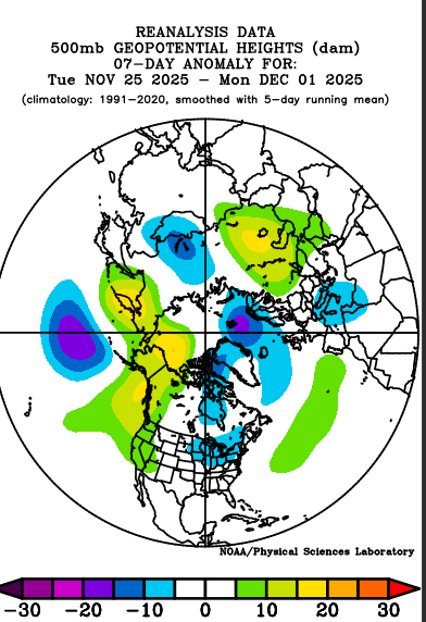
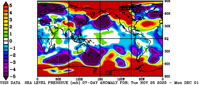
Ope! Two more posts came in while I was deliberating. RAP looks juicier. Otherwise my sports malaise creeps into weather... Thursday night looks similar to Monday night. Little bit of ice (trace) northwest of I-40 in the Mid-South. Light snow north of that, but probably less for northern Kentucky. Any light mix or ice area will get slick roads. Not enough QPF to mess with trees and power lines. Let's keep those themes all winter! Wake me up with Chattanooga can get below 40 deg during precip. January? Ah hell, let me get back into the severe thread and chew on Jag's post. That's what I'm talkin' about! Chatty rants aside, the cold pattern seems to want to stick around longer than initially forecast. While the MJO wants to complicate things, colder teleconnections are forecast to win out (on models). Even as the pattern relaxes (only somewhat) day 11-15 a possible reload awaits the weekend of Dec. 19 or going into the week of Dec. 22 which we'll call the 16-20 day. I'll throw in some gems from the Physical Science Lab. Keep that comin'