All Activity
- Past hour
-

2026 Mid-Atlantic Severe Storm General Discussion
high risk replied to Kmlwx's topic in Mid Atlantic
This little line moving through now is NOT the main front; it’s some sort of pre-frontal trough feature. The front won’t move through until later tonight. -
We hope its right but I wish it was a couple hours earlier.. might be some weakening by then
-

Mid-Long Range Discussion 2026
WinstonSalemArlington replied to BooneWX's topic in Southeastern States
-
Hopefully that extends into July
-
At least Weymouth got about 6". Enough for Scott to "break the 6" drought" and it look "VIOLENTLY BEAUTIFUL" out there! LOL.
-

2026 Mid-Atlantic Severe Storm General Discussion
nw baltimore wx replied to Kmlwx's topic in Mid Atlantic
Is this early frontal passage going to hurt our chances along and west of 95 later? I kind of expect anything that fires up later will be eastern areas. -
Main severe threat just like the last severe threat a couple weeks ago will be the damaging winds usually when the storms are approaching any affected area - this is especially dangerous at the many outdoor events this time of year during this weekend
-
Getting overcast by me. Keeping temps down hopefully! Nice breeze too.
-
Lake breeze keeps paradise weather around lakeside until late next week
-
I was going to post the same thing We had some decent sun until about 10:00. Pretty much clouds ever since. Out to mow my postage stamp-size of a lawn. Be back in 20 minutes. 67*
-

Late May/June 2026 Medium/Long Range
JenkinsJinkies replied to JenkinsJinkies's topic in Mid Atlantic
Check if the thermohaline circulation has weakened recently. A similar occurrence in 2013 was caused by it. -
Definitely not reaching 90 up here today. Currently 81 and deeply overcast but humid. Thankfully we’ll take it since we had baseball today.
-

2026-2027 Super El Nino
GaWx replied to Stormchaserchuck1's topic in Weather Forecasting and Discussion
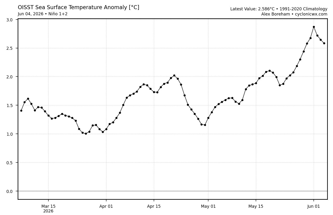
He was but my point is that Paita is just a very specific small area in the far edge of 1+2. It’s 1+2 that we follow because it matters significantly as far as Nino effects on the globe are concerned. And the current 1+2 is nowhere near record highs. I’m adding important context related to this tweet you posted. Without what I added, one could be fooled into thinking that 1+2 is at all-time highs, which is nowhere near true. -
End of ensembles trying to shift low heights into SE Canada. Wtf
-
Just spent 3 hours mowing, trimming back stuff, prepping pool stuff. Thank goodness it isn’t hot yet
-

2026-2027 Super El Nino
mitchnick replied to Stormchaserchuck1's topic in Weather Forecasting and Discussion
I think he was just pointing out that the entire 1+2 was cooler than 82/83. -
2026-2027 Super El Nino
mitchnick replied to Stormchaserchuck1's topic in Weather Forecasting and Discussion
Gimme' 82/83 please! Surprise 7" in December then the Megalopolis storm in February. My brother and I had to push my late uncle's van during the Noon hour when BWI recorded 4" in that hour. Thunder and lightning all day was just surreal. -

2026-2027 Super El Nino
snowman19 replied to Stormchaserchuck1's topic in Weather Forecasting and Discussion
I thought it was implicit in his tweet that he was speaking of daily anomalies in a very specific area and not region 1+2 overall. Nowhere in that tweet does he say region 1+2 overall -
keep checking here SPC Products Page
-
possible severe weather today?
-
Going to get hot and steamy these next several days. Grad party for my sister-in-laws kid today at a lake in the western suburbs. Already been watching my kids chase each other around with a garden hose this morning
-
80/64 at 10:45am. Gotta love warm and moist. Would be better without the clouds.
-
2026-2027 Super El Nino
GaWx replied to Stormchaserchuck1's topic in Weather Forecasting and Discussion
Levy is saying record high anom for Paita on 6/3-4/26. He doesn’t say how far back records go. And we’re certainly nowhere near the record anom for 1+2 overall for early June of 1983: The following are 1+2 monthly anoms 1983 5 28.26 3.85 1983 6 27.36 4.24 And 1997 was quite warm, too: 1997 6 26.12 3.00 These are weeklies 1983 much warmer 01JUN1983 4.4 08JUN1983 4.0 1997 fairly comparable to current non-relative although this is warmer than current relative’s low 2s: 28MAY1997 2.6 04JUN1997 2.5 11JUN1997 3.0 OISST 1+2 (non-relative) +2.6 (relative only in low +2s vs 4+ in ‘83):
-
Upton once again was wrong - this happens constantly - time for these guys to wake up their original forecast was Mostly Sunny - these clouds might also cut down on the chances of severe weather later - time will tell
-
Lost the sun during my run and it doesnt look like its coming back anytime soon