All Activity
- Past hour
-
Happy Hour GFS is back. Kind of...
-
-

November 2025 general discussions and probable topic derailings ...
alex replied to Typhoon Tip's topic in New England
I set up the ice skating rink tonight. Hope I don’t regret it lol, it’s quite early but it becomes a pain to do if there’s too much snow. Snow is really coming down now…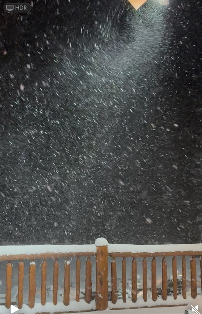
-


-
.thumb.png.4150b06c63a21f61052e47a612bf1818.png)
November 2025 general discussions and probable topic derailings ...
HIPPYVALLEY replied to Typhoon Tip's topic in New England
Yup -
 Must have been cold today. Top level down to 64 despite pellet stove running. Guess I didn’t have stove high enough.
 -
I think I’m tomorrow night or bust. Would take a pretty strong signal in the next 2 hours to get me outside - don’t think these precursor CMEs were supposed to be too special. Probably see something from SNP. Think the hope is these destabilize the magnetosphere a bit and the one tomorrow pops off. Hopefully an added benefit of extended darkness is that we’ve got a larger window and can worry about timing a little less. Fingers crossed.
-
First CME imminent according to a text alert I just got.
-
Lock it in
-
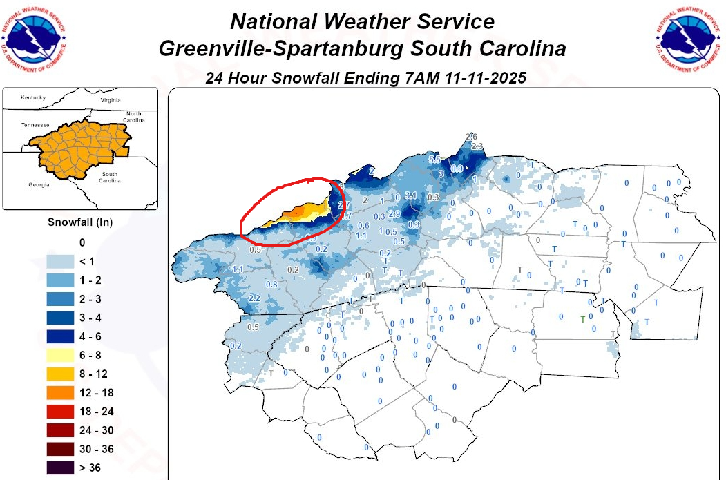
 That was actually from about 7 am this morning. Originally posted on Route 23 Life on Facebook.
 -
Get your cameras ready and fingers crossed for seeing the northern lights tonight and tomorrow night
-
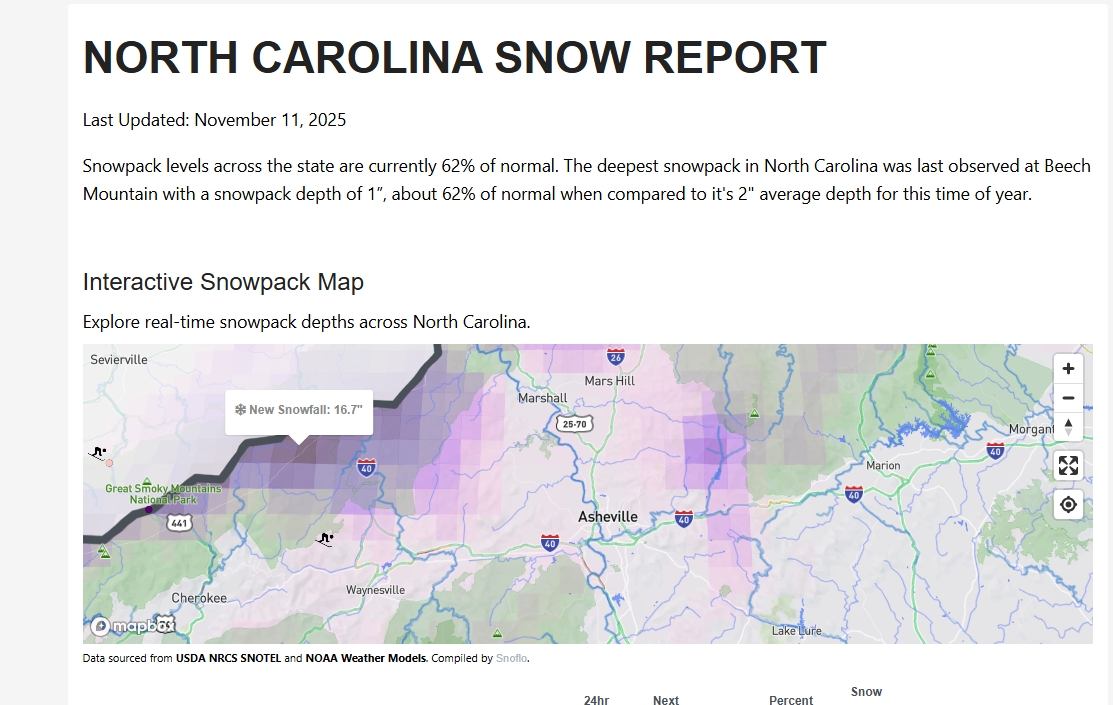
We got down to 14 this morning! Most of the snow is gone now except for shaded areas, but I got lots of cool pictures
-
Just got back from going to Beckley WV. Looks like high here was 37.8 degrees around 4pm, low was 19.5, not a bad day for Veterans Day. Going west late this am snow depth picked up immediately west of Covington, around 1-2 in White Sulphur Springs and Lewisburg, about 2.5/3 around Sam Black Church and then 3-4 in Beckley itself. A chilly day over there, warmest I saw on the car thermometer was 33. Currently 33.0/19.1 at 6:10 pm here.
-
Tonga + shipping emissions cleanup definitely boosted temps. Sadly the boost from aerosol cleanup is sticking around. Tonga has a few more years left to clear out.
-
Sunday River opening tomorrow.
-

November 2025 general discussions and probable topic derailings ...
dendrite replied to Typhoon Tip's topic in New England
Nice dippin dots on top -
The 4" number is arbitrary and/or coincidental. It is way over the top to claim that threshold is "required." If there is or was a meaningful causal relationship between December & winter snowfall at a particular reporting station, the causal factors have probably become less meaningful in the modern warming climate regime. This statistical connection is much more likely to represent merely a historical correlation than a causally predictive metric. There are likely too many confounding factors and too small a sample size for such a statistic to be meaningful. Snowfall is a very local phenomenon. Just a few miles can separate significant snow from flurries or rain. And the way snow is measured has changed over time. Maybe a novice statistician or a superstitious hobbyist would take this seriously. But I suspect others would rightly poke holes. When we have 1000 winter season to adequately power an analysis, we can revisit this argument.
-
The coldest air mass this season will begin to depart from the region. It will turn somewhat milder tomorrow. Tomorrow through Friday will see highs mainly in the upper 40s to lower 50s. Another brief push of cold air could arrive to start the weekend. Overall, temperatures will likely remain generally below normal through Saturday. Sunday could turn briefly milder before another cool air mass moves into the region. The ENSO Region 1+2 anomaly was -0.2°C and the Region 3.4 anomaly was -0.7°C for the week centered around November 5. For the past six weeks, the ENSO Region 1+2 anomaly has averaged -0.07°C and the ENSO Region 3.4 anomaly has averaged -0.55°C. La Niña conditions will likely continue through at least mid-winter. The SOI was -1.85 today. The preliminary Arctic Oscillation (AO) was -0.867 today. Based on sensitivity analysis applied to the latest guidance, there is an implied 59% probability that New York City will have a cooler than normal November (1991-2020 normal). November will likely finish with a mean temperature near 47.3° (0.7° below normal). Supplemental Information: The projected mean would be 0.4° below the 1981-2010 normal monthly value.
-
Just got a neighborhood biking lap in and my hands got legitimately cold...borderline frostbite weather with the wind. Is it spring yet?
-
 I wasn't home when it stopped snowing but it was sticking to everything, even the edges of the local streets. When I got home there was easily a quarter inch accumulated on everything but the streets.
 -

2025-2026 ENSO
Stormchaserchuck1 replied to 40/70 Benchmark's topic in Weather Forecasting and Discussion
Monster -WPO by the end of the 12z GEFS, last few days of November. Matching strong -QBO/negative ENSO years like 1989 and 2005 (although probably not as extreme). Remember I was saying I was curious if the strong -QBO/weak negative ENSO connection would make us really cold late Nov into the 1st half of December, like the coincidence that's happened over and over again (I say coincidence because the QBO is a Stratosphere index). It's looking more likely! -
I got an alert that the first CME is about to hit within 30 minutes as of this post.
-
maxed at 40, making today's avg 34.5 Nov 22 last year had similar cold
-
- Today
-
 I do think today’s high was something like 10-15 colder than anything else this season.


.thumb.jpeg.f5c6ba9d911ec96b3b124f8606aee58e.jpeg)


