All Activity
- Past hour
-
That 22.1 in January is incomprehensible these days. Was in grade school and remember the walks to and from school that month!
-
Rain storms ??
-
Oh wow that must have been cool with a sloped driveway. Would like to watch a vid of this. Haha. Mine slopes away a tiny bit, on one side. That ice crust was (is) so slick though that the sheared off sheets slid away with a push, and small ones not bad to just chuck away. I may have been making smaller sheets than them. Doing this method with a team and big sheets sounds kind of fun! I liked not dealing with wielding a shovel for the ice chunks part. I hold my own but am not the biggest, strongest person out there, creativity paid off.
-
This has been an objectively good winter so far. Need to keep it going.
-
Nothing brings on snow more than no snow in the long range ensemble runs! Seriously, as long as it’s cold, there’s a chance something materializes. I would be more worried if they were showing relaxation like earlier in January, which they not look to be, just moderation of a very anomalous cold pattern. Euro weeklies still look decent in terms of pattern, and they have been pretty good this winter in terms of general 500mb conditions/outcomes…
-

February 2026 Medium/ Long Range Discussion: Buckle Up!
Paleocene replied to Weather Will's topic in Mid Atlantic
My father in law who is here from Maine is befuddled by the salting. He says up there they mix in sand and only liberally salt slopes. Here MDOT and MCDOT are like the Romans after the third punic war. That's banter. Aside, I agree we need a thread for the slop on weds -

MO/KS/AR/OK 2025-2026 Winter Discussion
rockchalk83 replied to stormdragonwx's topic in Central/Western States
It does look like we'll get back to a stormier period once we get past the 10th of the month. Still TBD on the degree of cold air, but the Euro has been driving the bus on the potential for a stratospheric warming event mid-month. Been following Brian Bledsoe, who is a retired chief met from a TV station in Colorado Springs, and he has a podcast that discusses the upcoming pattern and the change to El Niňo. It's a very interesting watch/listen: -
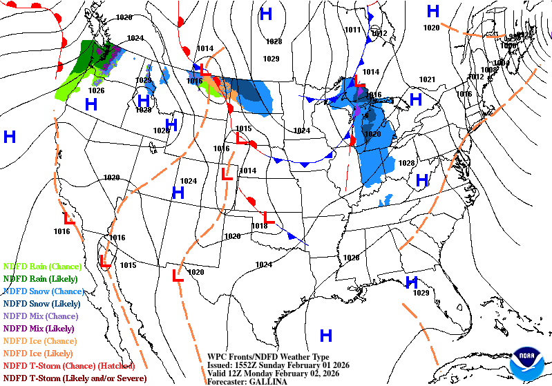
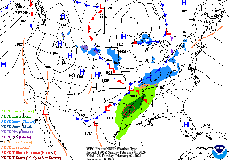
Decent call. Front moves across the N, with LP moving along the S sub Tues, bringing more snow to the OHV region.
-
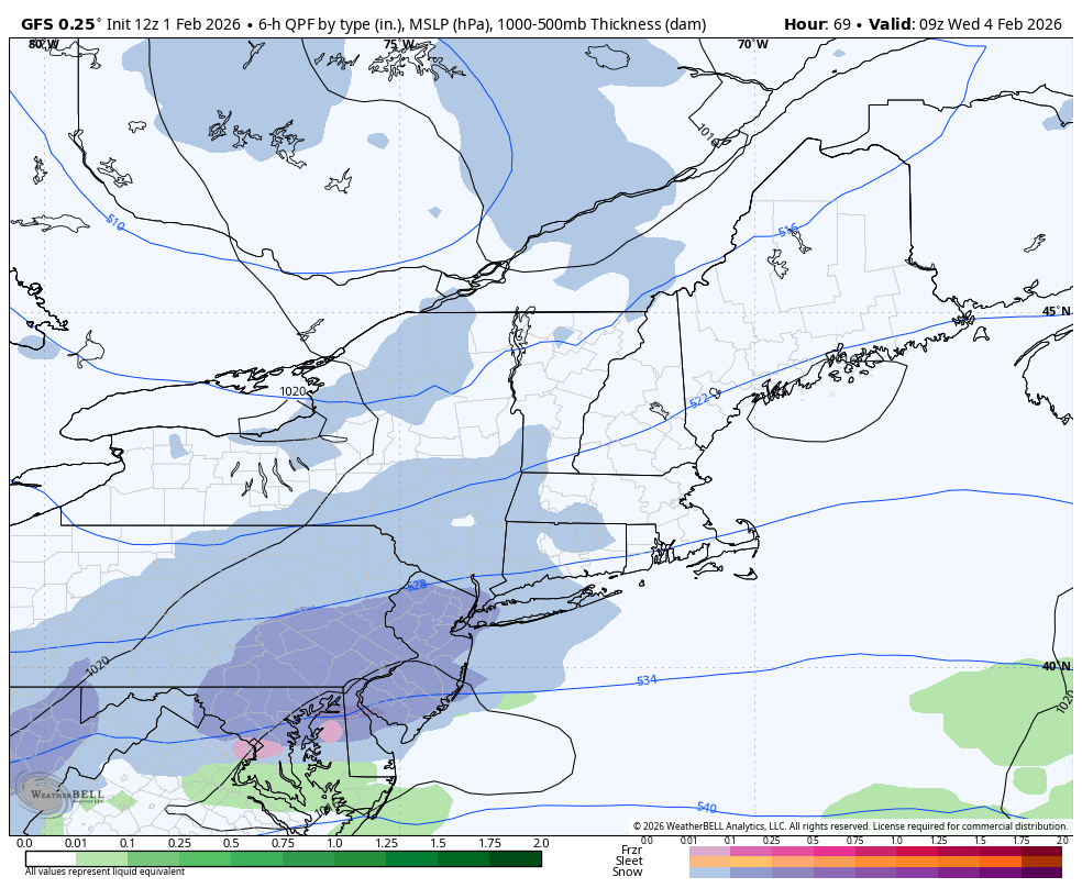
AIGFS continues the parade of storms. Granted they’re rain storms the second week of February not sure I buy that. But definitely a strong signal for that week
-

Southern MD / Lower Eastern Shore weather discussion
SnowtoRain replied to PrinceFrederickWx's topic in Mid Atlantic
Check back in on Thursday -

Is we back? February discussion thread
Damage In Tolland replied to mahk_webstah's topic in New England
Welcome back -

February 2026 OBS & Discussion
Freezing Drizzle replied to Stormlover74's topic in New York City Metro
The brutally cold season of 1976-1977 only yielded some 25 inches in the NYC area. (24.5" in CPK.)Yes, the snowfalls lasted. lolHeavy ice formation in the waterways. Area ferry services were suspended. Averages by month, Central Park:November 1976 41.7 F (The coldest November since 1917 surely "primed" the cold waters.)December 1976 - 29.9 F (Number 9 since records kept.)January 1977 - 22.1 F (Number 2 since records kept.)February 1977 - 33.5 F -

February 2026 Medium/ Long Range Discussion: Buckle Up!
CAPE replied to Weather Will's topic in Mid Atlantic
Probably should be a thread for the @WxUSAF weak ass frontal snow thing. Its something to track, just about in the short range, and for those who freak out over a jinx, the 'risk' is probably a coating to an inch. -
Not initially you didn’t. It was congrats Richmond and The Carolina’s from you. And that was before the Webb thing. And the one before that you didn’t either. It’s all good and doesn’t matter. Point is Things change all the time. As this just did, and last week too, and the week before that did too. This clipper/boundary whatever it looks to be, will change/morph too. What looks quiet now, may/or may not be as we move forward in time.
-
Uhoh he’s posting. Wolfie we’re just having fun. It’s been cold and very wintry.
-

Possible coastal storm centered on Feb 1 2026.
Ginx snewx replied to Typhoon Tip's topic in New England
My son's house on the beach in NC 15 inches
-

Jan 30th-February 1st 2026 Arctic Blast/ULL Snow OBS Thread.
GBOVolz replied to John1122's topic in Tennessee Valley
Crap.. gif didn’t work . -
with "slow" being the keyword a few hours above freezing will melt nothing - only thing now reducing the ice pack is evaporation and a compacting of it a natural process
-

Possible coastal storm centered on Feb 1 2026.
George001 replied to Typhoon Tip's topic in New England
It’s sunny out -

February 2026 Medium/ Long Range Discussion: Buckle Up!
nw baltimore wx replied to Weather Will's topic in Mid Atlantic
Science: Road salt doesn’t work well below 15 degrees. NWS: Tonight’s low will be 3. Tomorrow’s high will be 12. DOT: We should put down more salt. On topic, I’d gladly take a 2” powder coating on Wednesday. -
Jan 30th-February 1st 2026 Arctic Blast/ULL Snow OBS Thread.
GBOVolz replied to John1122's topic in Tennessee Valley
Can anyone tell me what this feature is that was on the nighttime satellite images? I’m trying a new way to make gifs so forgive me if this doesn’t work. lol Here’s a screenshot of what I’m talking about. . -

January 30th- Feb 1st ULL and coastal storm obs
MHCWEATHER replied to JoshM's topic in Southeastern States
100% and during one of the strongest bands (of many, ~2”/hr) it was probably 75% sleet. Actually, I bet my ratio was closer to 10:1 in Emerald Isle -

Central PA Winter 25/26 Discussion and Obs
Blizzard of 93 replied to MAG5035's topic in Upstate New York/Pennsylvania
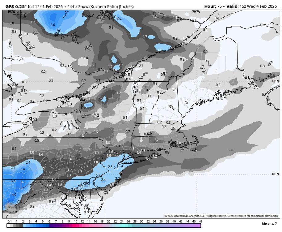
12z GFS bumped a little north & gets 1 to 2 inches by Wednesday morning to most of CTP.
-
Your global warming alarmists are dead.
-
The Wednesday shortwave has been ticking slightly more favorable across multiple guidance for several runs. The height field has been gaining every so slightly more meridional angle as it crosses south of us. The ULL in Ontario is a shame, but we might we able to trend this to a plowable event for some. Without that, there's nothing distinct on the horizon for a while. And spring is looming out in fantasyland.