All Activity
- Past hour
-
Tread lightly
-
Congrats on your colder rain!
-
Having meltdowns adds to the charm lol
-
Flurries are a fluttering.
-
-
Absolute dumpage! Best straight-down dendrites I have seen in quite a while. 1.5/hr easy.
-
Probably the best look we've seen all season other than what you guys got in the east got earlier.hopefully something transpires for someone
-

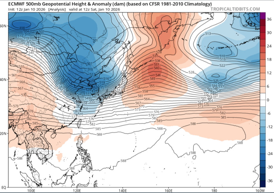
January 2026 regional war/obs/disco thread
ORH_wxman replied to Baroclinic Zone's topic in New England
These are also the types of wins we’d get in the 2010s constantly. Trends that helped us so often in the medium range instead of trending to crap. But when you’re going cold like we’ve been, very few of these work out. -
Though not without the occasional meltdown like the great folks fail of last February!
-

Central PA Winter 25/26 Discussion and Obs
pasnownut replied to MAG5035's topic in Upstate New York/Pennsylvania
well boys n girls how happy will the next hour(ish) be? we'll start off by adding the ICON to the thursday party. Mostly northers....but its now popped a SLP and norther 1/2 gets snow. Pops around somerset and traverses pa to Mt. Pocono. as we are almost approaching mid term w/ models it'd be nice to get them all to show something for thursday....or not. Headed out shortly w/ the mrs for some grub. Will check in later. -

Winter 2025-26 Short Range Discussion
A-L-E-K replied to SchaumburgStormer's topic in Lakes/Ohio Valley
Miss south -
I'm referring to the winter season in general. It'd have been more tolerable to date if it was seasonable cold during our dryness.
-
Alright GFS HAPPY HOUR
-
1.32" on the day; 1.33" total between yesterday and today. I'm counting every drop, dammit.
-
Maybe we'll have it go our way this time. Just haven't been that lucky the last few years.
-
Central PA Winter 25/26 Discussion and Obs
pasnownut replied to MAG5035's topic in Upstate New York/Pennsylvania
I'm just getting started. lol -
Why on Earth would ANYONE jump ship on winter on Jan. 10th???
-

January 2026 regional war/obs/disco thread
RUNNAWAYICEBERG replied to Baroclinic Zone's topic in New England
If AN seasons are working their back to us (like I think they are) then these are the types of “wins” in the mid range we need in order to get there. -
Find yourself someone who loves and hugs you the way DT does the Euro. On the flip side, it's by far the superior model so....
-
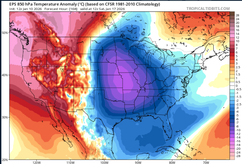
FWIW from. Wxrisk's Facebook page..... WILL DO A NEW SHORT VIDEO THIS EVENING ABOUT JAN 15-16. The last few runs on the operational GFS continued develop a huge snowstorm for the middle I thank New England coast. the model not me but the model is showing something like the January 2016 blizzard or Something like the 1909 or 1922 blizzards on the Mid-Atlantic coast. it's a very extreme solution. it's not out of the question but most of the data is against that kind of massive system. on the other hand the upper level energy on the 12z Saturday midday European model has taken a big step towards the GFS idea of a big Mid-Atlantic winter storm on January 15
-
I think a lot of what goes wrong on the ICON stems from where the PV is, and the increased interaction it is having with the north stream energy we want to dive in and phase.
-
Icon is a garbage model so it could show a 100” storm at 24 hours and I’d toss
-
114 I edited it. Typo on my part
-
He lives out towards Ashburn, so kind of in the same microclimate as me. He was a legit aviation met, so I picked his brain a bit when I saw him in the office, but I don't think he tracks these types of storms like we do lol (though does root for snow).
-
The AI Euro hasn't been terrible this winter, especially w/ surface features.


