All Activity
- Past hour
-
Went up to 3.8" after the squalls (yesterday and today), and just added 1.8" in the last hour under the big Ontario band. LFGGGGGG 5.6" two day total and counting.
-

January 24-26: Miracle or Mirage JV/Banter Thread!
Kay replied to SnowenOutThere's topic in Mid Atlantic
Suicides followed -
Purpled!! Love your maps and forecasts. Everyone would and should be happy if this come to fruition
-
Is there any data input to these models and if not when does the sampling begin.
-
But only 21 hrs
-
January 24-26: Miracle or Mirage JV/Banter Thread!
Kay replied to SnowenOutThere's topic in Mid Atlantic
Beware, one was posted that wasn't finished snowing -
Snow map incoming from me
-

“Cory’s in LA! Let’s MECS!” Jan. 24-26 Disco
Damage In Tolland replied to TheSnowman's topic in New England
Get “down here” -
Heard my first typical snow doubter in the booth near us at dinner tonight... "Man it ain't gonna snow... Maybe a few flurries. I ain't got no faith in them weather men. It was 50 degrees today! I wish I could get paid to be wrong all the time!! Hahahaha" Sent from my SM-S911U using Tapatalk
-
He is still probably right. But the way he posts is worth a chuckle.
-

Central PA Winter 25/26 Discussion and Obs
Festus replied to MAG5035's topic in Upstate New York/Pennsylvania
Sticking with 17.0. -

January 2026 regional war/obs/disco thread
Typhoon Tip replied to Baroclinic Zone's topic in New England
It’s interesting… there’s been a very bright index signal for many days, actually going back a couple of weeks. Very persistent with the whole wholesale index swap of the PNA. In fact, it’s on the order of four whole standard deviations from negative phase to positive in less than a week That’s almost impossible to do without a restoring system Yet we have some operational model runs that are putting out solutions here and there, admittedly, lacking continuity as they seem to evaporate a run later. But when they show up, they’re hyper bombs I mean down into the 960s and stuff at a latitude that seldom realizes pressures that might take on it is that there’s a huge huge non-linear signal there and we’re just waiting on the linearity of the wave transport in the atmosphere to actually come into phase with it. Anything that does just gets that gigantic kickback and that’s why we’re getting these inconsistencies between nothing and extreme. Regardless of what’s really going on there I don’t really agree that there’s no signal and that it shouldn’t be watched - not saying you are. It’s just my two cents. -
Beautiful Sunday Snow, mainly after noon. High near 15. Calm wind becoming northeast around 6 mph in the afternoon. Chance of precipitation is 80%. New snow accumulation of 3 to 7 inches possible. Sunday Night Snow. The snow could be heavy at times. Low around 8. Northeast wind 6 to 8 mph. Chance of precipitation is 100%. Monday Snow, mainly before 4pm. High near 18. Northeast wind 7 to 9 mph becoming northwest in the afternoon. Chance of precipitation is 80%. Monday Night A chance of snow before 10pm. Mostly cloudy, with a low around 2. Northwest wind around 8 mph. Chance of precipitation is 40%.
-

January 25-26 Winter Storm Potential
Hurricane Agnes replied to Ralph Wiggum's topic in Philadelphia Region
And so you proceeeded to send me down the rabbit hole to sub to that. I remember when they first came out and were free (for some stuff). But times change... Their 18z GFS 282 hr sleet map - still looks to be down just below Philly metro.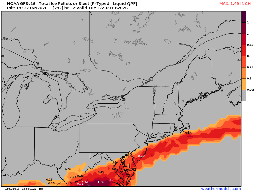
-
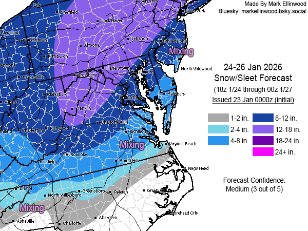
Initial snow+sleet forecast... main issue will obviously be the mixing that comes in on Sunday, mainly along and east of I-95. Very excited as my kid is 6 and has not seen a 6"+ snow event.
-
Thats actually Elyse pointing lol
-

Possible Record Breaking Cold + Snow Sunday 1/25 - Tuesday 1/27
Franklin0529 replied to TriPol's topic in New York City Metro
Ain't what it used to be since the upgrade that's for sure -
2025-2026 Fall/Winter Mountain Thread
franklin NCwx replied to Buckethead's topic in Southeastern States
Correct. Turns us over to heavy rain. -

Possible Record Breaking Cold + Snow Sunday 1/25 - Tuesday 1/27
Prue11 replied to TriPol's topic in New York City Metro
I Know the euro has gotten worse over the years. It used to be a very reliable model -

“Cory’s in LA! Let’s MECS!” Jan. 24-26 Disco
Twitching Trucks replied to TheSnowman's topic in New England
Maybe find some place to score some edibles along the way and calm down . -

1/24-1/25 Major Winter Storm - S. IL, IN, MI and OH
Cary67 replied to A-L-E-K's topic in Lakes/Ohio Valley
Call of 1.0" here -
FWIW the RAP is similar to the GFS the whole run. .
-
Possible Record Breaking Cold + Snow Sunday 1/25 - Tuesday 1/27
Franklin0529 replied to TriPol's topic in New York City Metro
Was better then the euro for last weekend. Euro was always way to offshore an trended closer to coast where the GFS was. The AI have been the best an they drop around a foot in the city. -
https://x.com/bam_weather/status/2014465122735996969?s=46&t=zI7gUCUKxe9KG7iojSwUTQ This guy is hilarious .
-
I think it was actually a little less precip that run.


