All Activity
- Past hour
-
Glad you mentioned this. I don’t fully understand the modelology or the long term possibilities, and while I don’t discount them, there’s definitely a *feel* we overlook a lot. It’s like analytics and baseball; while they’re very useful, there’s an eye test, too, which you can intuit and tell when a pitcher can master hitters. I know it’s a La Niña, so it’s usually colder earlier in the season, but that feel is there. Thanks for coming to my TED talk. .
-

The Return of the 12/5 Snowstorm
SomeguyfromTakomaPark replied to SnowenOutThere's topic in Mid Atlantic
It’ll be cool to get some snow in minimal sun angle season. None will be wasted. -
The snow and ice crews out on the Deep South shore is hysterical. Slow previous two years . .
-
 Baum changed their profile photo
 -

December 2025 Short/Medium Range Forecast Thread
Holston_River_Rambler replied to John1122's topic in Tennessee Valley
Overnight ensembles are interested wrt wintry weather in the period around Dec 11-12. As many changes as we've seen with this upcoming system overnight Thursday into Friday AM, will be interesting to see how the 11-12th evolves over the next 5 days or so. -

December 2025 regional war/obs/disco thread
mahk_webstah replied to Torch Tiger's topic in New England
Wunderground has snow 3 straight days 10-12th. Light but indicative of the conversation about small systems and clippers. Cold and somewhat active is good and can bring surprises that we don’t agonize about for 7 days. -
I’ll take whatever the gfs is smoking on that Monday system
-
A little crud on the car. Deep winter.
-
Snow contest for iad might be over!
-
The Return of the 12/5 Snowstorm
SomeguyfromTakomaPark replied to SnowenOutThere's topic in Mid Atlantic
Big broad area of accumulating snow! Cold temps! Let’s go!! -
Thanks, i never posted it in the NYC forums because i figured most would catch it in SNE and didn't want to be redundant. But yeah we got a whole Tri-State section and all the storms in the Winter Storm Archive have Tri-State Area snowfall maps included, as well as radar, sfc and upper air animations. I'm currently in the middle of the 95-96 season which should be done in the next couple weeks. I remember telling @LibertyBell that season would probably never happen but i decided to go back to 94-95 since i can get radar back to Jan 1 1995. I'm working on this past storm atm so if anyone has any reports let me know and ill include them.
-
Sold!
-
2 days out and there’s this much difference between gfs and euro. Ugh can it ever just be some agreement.
-
Winter 2025-26 Medium/Long Range Discussion
Baum replied to michsnowfreak's topic in Lakes/Ohio Valley
Well, however it plays out well ahead of the game this season. -
6z Euro
.thumb.png.b6d5dc9d1b1de02efbae390f6f1c32c4.png)
-
2 inches after this 6.1 total
-
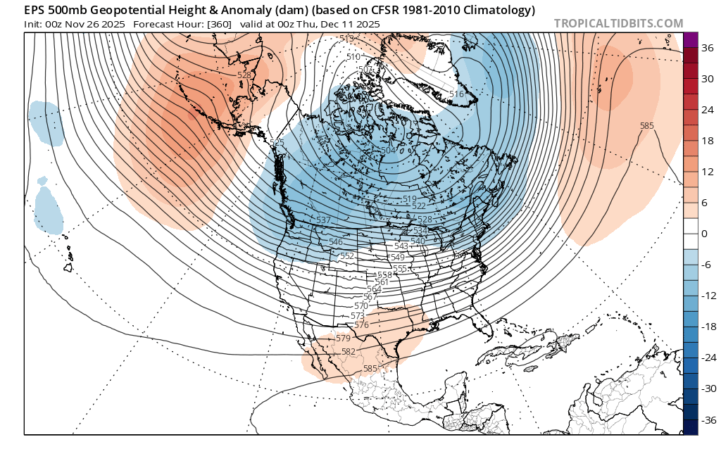
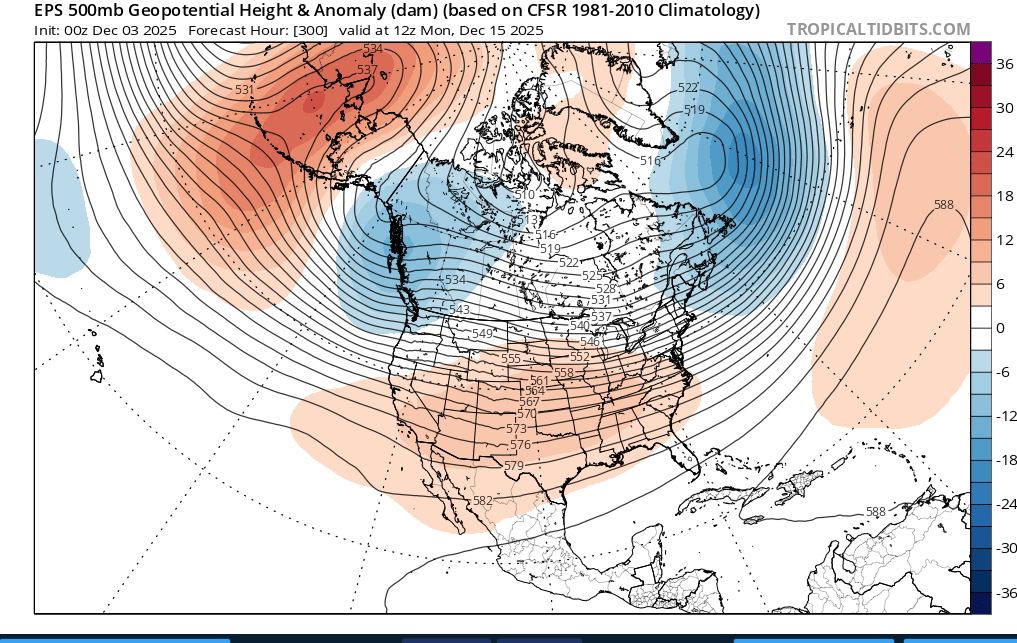
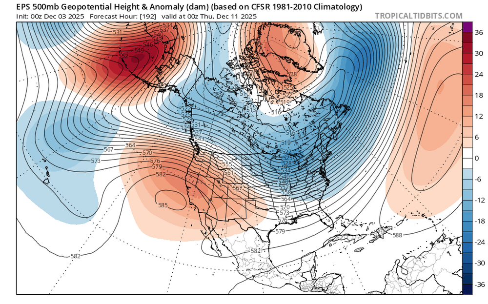
I'd be careful in cancelling any warmup because both ensembles try (operational word, "try") to send a trough into the western US giving us a bootleg -PNA. But any warmup appears to be only temporary. Maybe a week or so, or even a few days. When I play out the roll forwards from 11-15 to 6-10, that western trough retrogrades NW and instead pops up a flat ridge there instead, allowing cold air to move SE across the CONUS. For example, comparing 360 hr from Nov 26 against 192 hr from today's EPS run, you can see what I'm getting at. Old run (11/26): New run (today):

-

Central PA Fall Discussions and Obs
mahantango#1 replied to ChescoWx's topic in Upstate New York/Pennsylvania
-
5.0" was the event total here. All snow from 10am to 5pm with 3.3" of accumulation, then about four hours of sleet (0.5" accumulation) with a brief period of freezing rain before going back to snow after 9pm. Picked up an additional 1.2" of snow after the late changeover.
-

December 2025 regional war/obs/disco thread
Kitz Craver replied to Torch Tiger's topic in New England
Active Northern stream from both camps. Something will pop. Bring back the clipper of yore! -

Winter 2025-26 Medium/Long Range Discussion
A-L-E-K replied to michsnowfreak's topic in Lakes/Ohio Valley
looking like a bust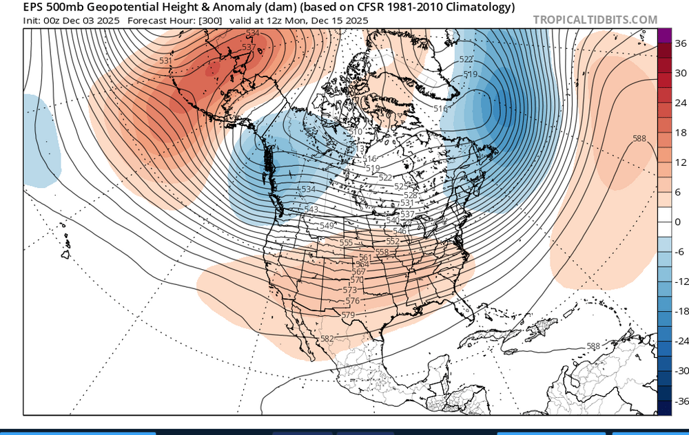
-
Another potential warm up cancelled?
-
End of next week also looks intriguing at h5 but as it looks now on the ens mean we would need a piece of NS energy to dig further south to get us a little storm.
-
We got pieces in place on the ens run. Why sweat the run to run details on the op runs at this range- its literally going to change every run. Just no way to know how the NS vorticity will interact- but we have some digging energy taking the southern route to work with.
-
This has been the reality for the past decade. Bluewave constantly points this out. It's the same kind of storm track too. The only ones that really benefit are anyone around the lakes and C/NNE. Maybe the pattern will flip again one day but we need to see a complete change in the forcing out in the Pacific.
-
Thanks for the heads up. I see that on Google Maps. great


.png.13ef83fa29684c9bb184a9b42b836fbd.png)