All Activity
- Past hour
-

December 2025 regional war/obs/disco thread
Sey-Mour Snow replied to Torch Tiger's topic in New England
Ya feet of digital snow is usually modeled a few times a week it seems in January and February. But if it were to ever actually happen, December would be so much better. -
Just lost power because of 45-50 mph gusts. We were supposed to host Thanksgiving. Hopefully the power comes back on by morning.
-
Icon might hop on board here .
-
3K NAM picking up on this moisture as well. Nothing major but will feel like winter. Sent from my SM-G998U using Tapatalk
-
Just amazing. You took Wills photographic memory and digitized it. lol Really appreciate your effort this is gold!!!
-

E PA/NJ/DE Autumn 2025 Obs/Discussion
Duca892 replied to PhiEaglesfan712's topic in Philadelphia Region
Mike Masco favoring folks in Ohio... waiting for 12z GFS... we are so back -

2025-2026 ENSO
40/70 Benchmark replied to 40/70 Benchmark's topic in Weather Forecasting and Discussion
Sure, it can be argued that perhaps that PV will recover more slowly than some are implying, but I think interpreting that subtle weakening around Xmas as a major disruption is what is insane...especially on the heels of this current head-fake. December reversals are exceedingly rare, which is why reflection events are so common place in January and February. -
Rain Totals (11/25) New Brnswck: 0.76 NYC: 0.74 EWR: 0.72 LGA: 0.58 JFk: 0.58
-
Could see some flakes tomorrow for Thanksgiving. Going to be freaking cold too just in time for Thanksgiving. Sent from my SM-G998U using Tapatalk
.thumb.jpg.91fed4eeac72f2f53a28cce7c13aa2c7.jpg)
.thumb.jpg.d0732583843dbfff90ac6ed0bd1065f4.jpg)
-
Was it the euro last winter that did the same in Feb? Toss all those far and wide.
-
Acting like a forecast for 2+ weeks into the future is a foregone conclusion is insane. Think its fair to post a forecast that might show things trending differently than they are being shown now.
-

Central PA Fall Discussions and Obs
Jns2183 replied to ChescoWx's topic in Upstate New York/Pennsylvania
Trust the vibe! We are due for a December to Remember Sent from my SM-G970U1 using Tapatalk -

December 2025 regional war/obs/disco thread
Ginx snewx replied to Torch Tiger's topic in New England
Impressive Lenticular in Gorham NH yesterday. Stole from FB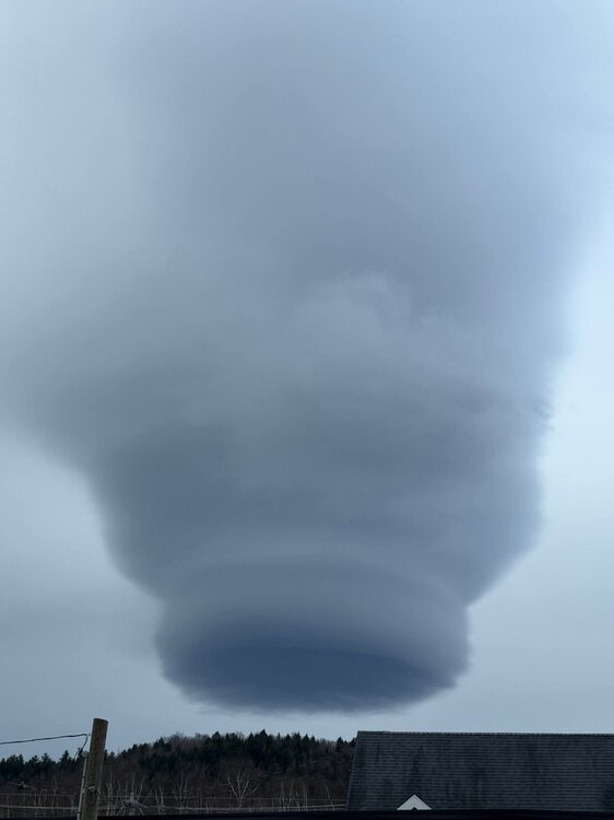
-
A step in the right direction. Models are far from seeing the pattern out into December.
-
Was looking at that. Temps are going to crash as well.
-
12th Annual Mid-Atlantic Snowfall Contest
Grothar of Herndon replied to RodneyS's topic in Mid Atlantic
BWI: 20.5” DCA: 14.2” IAD: 25.3” RIC: 12” SBY: 10.8” -

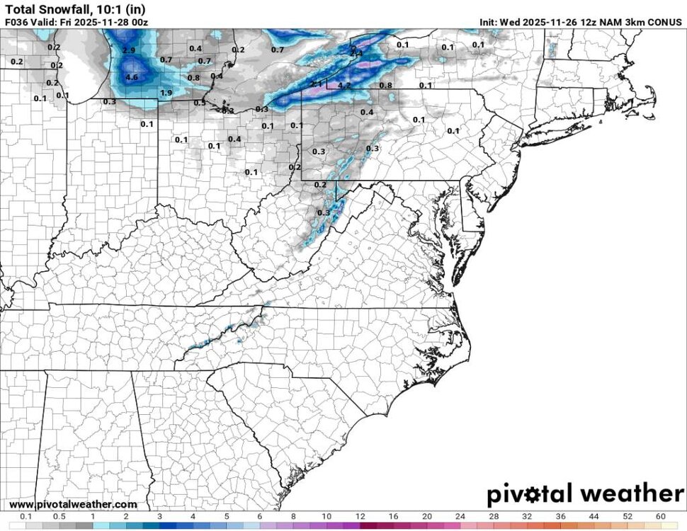
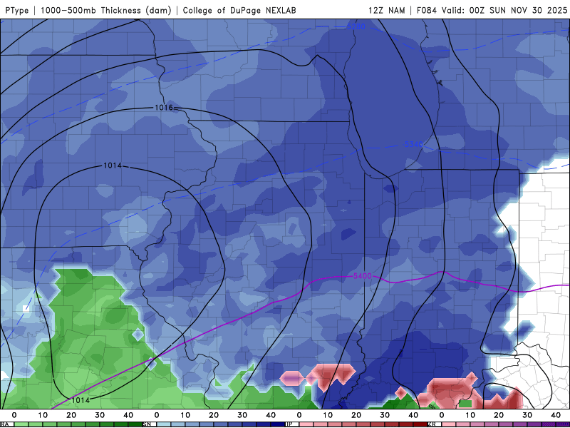
Nov 28-30th Post Turkey Day Wintry Potential
Sciascia replied to Chicago Storm's topic in Lakes/Ohio Valley
84hr NAM (lol) but sharing as it’s reaching range. Run ends when snow is continuing to fall.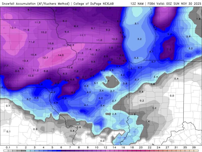
-

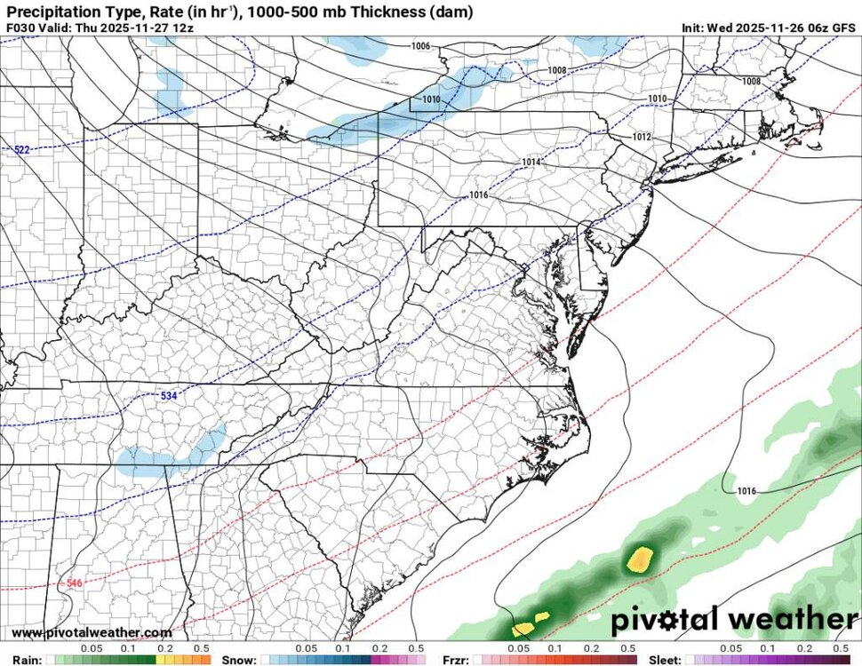
November 2025 general discussions and probable topic derailings ...
dryslot replied to Typhoon Tip's topic in New England
Thursday -
Pretty classic HP position on both models for CAD at least. Maybe an early season thumper to slop?
-
Please let us know if the cold air is gonna be like the LA Rams defense and strong or the Commanders defense that lets Barkley(warm air) get 200 yds
-
December 2025 regional war/obs/disco thread
Sey-Mour Snow replied to Torch Tiger's topic in New England
I’d sacrifice next season if the 6z gfs verified with probably more snow leading up to Christmas.. 40-60” of snow after that 360 hour fantasy storm in mid December for all of New England and very cold.. weenies can dream. I’m sure the 12z runs will be congrats Atlanta then a raging SE ridge -

Pittsburgh PA Fall 2025 Thread
Burghblizz replied to TheClimateChanger's topic in Upstate New York/Pennsylvania
Lol - “no longer possible”. Calendar day records can be deceiving for obvious reasons. Obviously, this is a sign of slow stretches overall. But nothing helps to inflate “last time since” like a calendar day view. I can see why you like them. For example - the stretch leading up to ‘92 was (anecdotally) the slowest of my lifetime. The good news is that just like the ‘78 stretch, epic weather broke out after that. That ‘92 storm was great and disappointing all in one. There was a thump with a primary low, and a bomb on the coastal that was far enough south that it looked to hammer us as it came up the coast. But it was just a tick east. So the airport total was way low. City got a foot, 12-18” southeast, with 3’ in the ridges. It would be a “what could have been” storm if this board existed. But there were places in the southern and eastern suburbs that went on to crack 15” 3 times over the next 13 months. -
Good luck. We're all praying you two have the mojo this winter.
-

Central PA Fall Discussions and Obs
Eskimo Joe replied to ChescoWx's topic in Upstate New York/Pennsylvania
The 00z GFS/UKMET/Euro and 06z GFS/GEFS would get most of this subforum to climo snowfall for December by December 5th. Very impressive. -
You and I are both on the winter desks this weekend when this potential storm is inside 72 hours. We'll see how this trends over the next couple days!


.jpg.450bd542b9324d89971c945b21697213.jpg)
.jpg.9194b49ba95e90f12bdfea38786301b8.jpg)


