All Activity
- Past hour
-
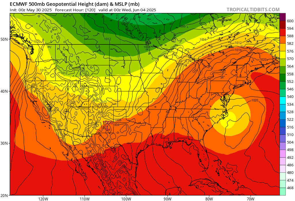
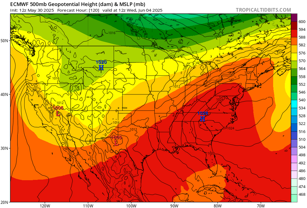
oh that high in the 12z run is in a GREAT spot, there would be a downsloping westerly or northwesterly wind with a high in that position !!
-
Yikes. Still, the weather geek in me wishes that threat was up to I-80 instead of US-30. I've got the video cameras out, so it would make an interesting finish to my work night and video
-
The location of the upper low holds the key to our first 90°. If it gets out of the way like the 12z run today, then we’ll have our first 90° next week at the usual warm spots. More of a 0z solution then we’ll top out in the 80s. This is a pretty big jump in just one run. But models usually struggle with closed low solutions. 12z 0z

-
If Lebanon can pick up 2.80”+ before the end of the month we will hit 12” of rain on the month…amazing .
-
Correct me if I'm wrong but that would be a line of at least quasi-supercellular activity?
-
Sun popped out a bit more here and temps went from 74 to 78
-
HRRR for a few hours in the future
- 809 replies
-
- 2
-

-
- severe
- thunderstorms
- (and 2 more)
-
I think our line we are watching is in WV right now for this evening
-

Central PA Spring 2025
Itstrainingtime replied to canderson's topic in Upstate New York/Pennsylvania
Severe threat until 1am, Tornado threat up to Rt. 30. Expecting everyone to get .5" - 1.5" of rainfall with some areas getting 3-4". More storms with hail tomorrow PM but more scattered and brief in nature. -
Radar seems ahead of schedule relative to meso models
-
Dark clouds and a pop up storm just east of me.
-

2025 Lawns & Gardens Thread. Making Lawns Great Again
dendrite replied to Damage In Tolland's topic in New England
I thought I had poison ivy coming up by my run, but after some careful leaf IDing I think it’s box elder. -
Still not sure what I was quoted for/getting called out on there... weather this week wasn't terrible we had a couple of nice days, but it wasn't that great either. Lots of overcast conditions, rained a few days, and now we have a 990 low tracking up the Appalachian's into the CT River for Saturday. Even after the low passes it's looking like drizzle and breezy conditions in it's wake until it pulls much farther north for Eastern New England. If this is COC - get to Planned Parenthood for a screening... Looks like the pattern will break next week (thankfully)...
- Today
-
next week may or may not offer a heat wave... I figure for the 80s mid week, but the ceiling is higher so we may manifest that more obvious as we get closer. we'll see. 12z GFS ends the run with big heat implication. Full bird SW/Sonoran release event... talkin 576 to 581 thickness from New Mexico to Boston Harbor. 360+ hours, so nothing can go wrong with that of course heh
-
Off topic question here. I have an older laptop that works great. The front face of the laptop does not snap in place at all anymore. The screws are in normally. When I've tried to get the front face to snap in place, it goes back to the situation you see in this picture. I am wondering if there's some sort of fix for this.
-
Rain arrived early here. Wonder if this initial line will mess with the Orioles decision to move their night game up to a 4:30 start time.
-
it's back here again too, it's happened 3x now it's here for 30 minutes and gone for 30 minutes lol.
-
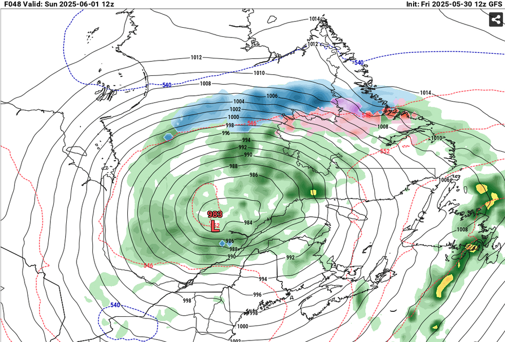
I wonder if this is late in the year/climo for snow on June 1 at up there. I wonder if it is late in the year/relative to CC climo for that matter
-
I figured it would get here Sunday when we get those strong offshore winds.
-
Or have kids. It’s just too dangerous out there.
-
Wiz is never going to sleep again.
-
Working, so not much chance to hunt it down. Cliff notes, or a link?
-
With mid and high levels clouds pushing in, I wonder if this puts a lid on a more robust tornado potential?
-
Expanded south and west, now the western 2/3's of the forum in a tornado watch.
-
They tend to dangle above you from the ceiling and watch while you sleep, sorta of like one of those dangling crib toys you find in a nursery