All Activity
- Past hour
-
Looks like they were added at around 8pm
-

“Cory’s in LA! Let’s MECS!” Jan. 24-26 Disco
Snowcrazed71 replied to TheSnowman's topic in New England
It was just strange that all the other models were higher and this was the lowest.... But I wasn't aware it was very conservative. Thanks for explaining -
 Yes especially driving toward Philly will be crazy by 10:00 AM.
 -

January 25-26 Winter Storm Potential
Ralph Wiggum replied to Ralph Wiggum's topic in Philadelphia Region
Initial thump colder and heavier precip -

Jan 24-26 Weekend Snow and Sleetfest Model Thread Part Tres
SnowenOutThere replied to H2O's topic in Mid Atlantic
Seems like multiple studies disagree with each other. One I read/skimmed said that if we have a freezing layer of 3000+ feet below the elevated warm layer it’ll refreeze to sleet regardless. Just such an extreme setup to where it all breaks down. -

Jan 24-26 Weekend Snow and Sleetfest Model Thread Part Tres
umdterps29 replied to H2O's topic in Mid Atlantic
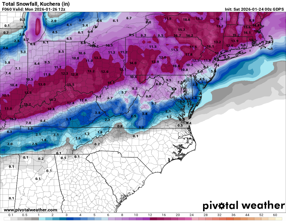
Can someone post CMC kuchera? . -

January 2026 regional war/obs/disco thread
Prismshine Productions replied to Baroclinic Zone's topic in New England
GFS is the kicker for the Bills next weekend... Wide Right Sent from my SM-S166V using Tapatalk -

Possible Record Breaking Cold + Snow Sunday 1/25 - Tuesday 1/27
jm1220 replied to TriPol's topic in New York City Metro
Hopefully you're right. I highly doubt we jackpot around here in this type of system, I can definitely see it for I-84 corridor to Boston. -

January 25-26 Winter Storm Potential
Kevin Reilly replied to Ralph Wiggum's topic in Philadelphia Region
Umm cmc backed off though southern sections nodding to Nam -

January 24-26: Miracle or Mirage JV/Banter Thread!
nw baltimore wx replied to SnowenOutThere's topic in Mid Atlantic
I tried that for sleeping and all it did was make me worry that my basement was going to flood. -

“Cory’s in LA! Let’s MECS!” Jan. 24-26 Disco
78Blizzard replied to TheSnowman's topic in New England
Something is wrong with Pivotal's Ukie algorithm. The 18z and 0z 10-1 snowfall totals are much higher than the qpf would suggest. -

Jan 24-26 Weekend Snow and Sleetfest Model Thread Part Tres
T. August replied to H2O's topic in Mid Atlantic
17/-7 in Havre de Grace -
Possible Record Breaking Cold + Snow Sunday 1/25 - Tuesday 1/27
jm1220 replied to TriPol's topic in New York City Metro
GGEM looked good, not as good as RGEM but solid. IMBY it has 10" of snow at 10-1 then probably 0.3" liquid as sleet so that would add another inch. -

January 2026 regional war/obs/disco thread
40/70 Benchmark replied to Baroclinic Zone's topic in New England
Yea, over Bermuda. -

Possible Record Breaking Cold + Snow Sunday 1/25 - Tuesday 1/27
Snowlover11 replied to TriPol's topic in New York City Metro
Might be some virga for an hour or two, but this is going go to come in like a wall. -

January 24-26: Miracle or Mirage JV/Banter Thread!
MacChump replied to SnowenOutThere's topic in Mid Atlantic
Thought your last word was viagra on first read. Sort of made sense in context. -

Possible Record Breaking Cold + Snow Sunday 1/25 - Tuesday 1/27
Mo Snow replied to TriPol's topic in New York City Metro
When are we expecting this to start? How am I looking for a Sunday morning commute from NYC to Philly. Obviously the earlier the better but is it going to get crazy by 10AM? -

Pittsburgh/Western PA WINTER ‘25/‘26
MikeB_01 replied to Burghblizz's topic in Upstate New York/Pennsylvania
Awesome use of AI! So perhaps the NAM is not as north as we thought. More in line with the 3k . -

January 2026 Medium/Long Range Discussion
NorthArlington101 replied to snowfan's topic in Mid Atlantic
-

Pittsburgh/Western PA WINTER ‘25/‘26
colonel717 replied to Burghblizz's topic in Upstate New York/Pennsylvania
I think this may be most CMC has shown. For all AGC.
-

Possible Record Breaking Cold + Snow Sunday 1/25 - Tuesday 1/27
SACRUS replied to TriPol's topic in New York City Metro
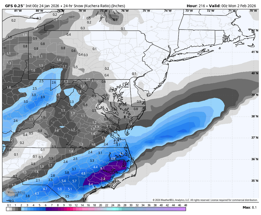
1/24 00z GGEM Total QPF Total Snow (10:1) -

Jan 24-26 Weekend Snow and Sleetfest Model Thread Part Tres
bncho replied to H2O's topic in Mid Atlantic
Does anybody have the UKIE kuchera? -

Jan 24-26 Weekend Snow and Sleetfest Model Thread Part Tres
Ji replied to H2O's topic in Mid Atlantic
Canadian at 18z looks pretty good! -
Has Morristown been in the WSW, or have they just been added? It seems they were in the Ice storm warning earlier in the day.
-

Possible Record Breaking Cold + Snow Sunday 1/25 - Tuesday 1/27
hooralph replied to TriPol's topic in New York City Metro
He must have meant 2” LE / hr at 15:1, which would be 30”/hr and indeed pile up very quickly.