All Activity
- Past hour
-
Wonder how much further we've slipped into drought when the new report comes out tomorrow?
-
Nice call (assuming you meant this and not that the sun would not rise in the east thing)
-
Philly has had less than 10 on a couple of occasions… I think 2004 is one of those… not sure about 1996 as that is when I moved here from Pittsburgh. However, 30 always seems attainable here especially lately.
-

Augdewst 2026: Summer's Last Stand
dendrite replied to Prismshine Productions's topic in New England
5.69” in Nashua west of the Everett. -

Augdewst 2026: Summer's Last Stand
CoastalWx replied to Prismshine Productions's topic in New England
That’s got SE CT and RI written all over it. But there’ll be some stuff popping this afternoon too I think. -

Augdewst 2026: Summer's Last Stand
Damage In Tolland replied to Prismshine Productions's topic in New England
Utah? -
Augdewst 2026: Summer's Last Stand
CoastalWx replied to Prismshine Productions's topic in New England
His current side piece? -
Augdewst 2026: Summer's Last Stand
Damage In Tolland replied to Prismshine Productions's topic in New England
That Delmarva stuff may sort of sideswipe River East. It’s got Easterly component -
Augdewst 2026: Summer's Last Stand
Damage In Tolland replied to Prismshine Productions's topic in New England
Which wife? -

E PA/NJ/DE Summer 2026 Obs/Discussion
Hurricane Agnes replied to PhiEaglesfan712's topic in Philadelphia Region
Now up to 1.40" with light rain (1.82" 2-day). Temp 75/dp 74. -
Harrison, NJ is on track for their first 9 consecutive years with over 30 days reaching 90°. The last time they had under 10 days was 1996. That year is still the reigning champ for the most snow and least 90° days across the area. Time Series Summary for HARRISON, NJ - Jan through Dec 90° Days Click column heading to sort ascending, click again to sort descending. 2026 26 151 2025 37 0 2024 41 0 2023 33 0 2022 44 0 2021 38 0 2020 39 0 2019 39 0 2018 47 0 2017 23 0 2016 40 0 2015 32 0 2014 16 0 2013 25 0 2012 35 21 2011 31 30 2010 50 30 2009 15 42 2008 22 19 2007 22 5 2006 30 4 2005 41 9 2004 17 6 2003 14 8 2002 47 8 2001 30 7 2000 15 14 1999 39 4 1998 18 2 1997 20 5 1996 8 17
-

Augdewst 2026: Summer's Last Stand
RUNNAWAYICEBERG replied to Prismshine Productions's topic in New England
You would think. Warm and wet, shoot me now… -

Central PA Summer 2026 Discussion/Obs Thread
Itstrainingtime replied to Voyager's topic in Upstate New York/Pennsylvania
Finished with a paltry 0.12" in Maytown. Seem to be at the bottom of the totem pole for weeks now. Also, the forecast for today has really changed! Today was to be a heavy rain/flood risk, it now appears that skies clear out this afternoon with likely no rain at all until Wednesday. -
Augdewst 2026: Summer's Last Stand
dendrite replied to Prismshine Productions's topic in New England
You’ll have a lot of explaining to do if your wife ever reads this forum lol -
Augdewst 2026: Summer's Last Stand
CoastalWx replied to Prismshine Productions's topic in New England
Gonna semi stein here while Tblizz gets into the gravy train with stuff down in NJ. -

Augdewst 2026: Summer's Last Stand
TauntonBlizzard2013 replied to Prismshine Productions's topic in New England
Lmao. Good grief. -

Augdewst 2026: Summer's Last Stand
Brian5671 replied to Prismshine Productions's topic in New England
in an el nino? wet winter -
Augdewst 2026: Summer's Last Stand
RUNNAWAYICEBERG replied to Prismshine Productions's topic in New England
We’ll dry out come December though and stein our way through winter… -
Augdewst 2026: Summer's Last Stand
Bostonseminole replied to Prismshine Productions's topic in New England
Pouring at the office in Bedford, MA— feels like Miami . -
Augdewst 2026: Summer's Last Stand
Brian5671 replied to Prismshine Productions's topic in New England
mod rain here continuing-next batch gearing up...probably going to end with 4+ -
Augdewst 2026: Summer's Last Stand
Damage In Tolland replied to Prismshine Productions's topic in New England
1.26” so far . This has gone pretty much like we thought with a narrow zone getting high totals but most just getting downpours . That thing that went overhead here had some solid 45-+ gusts with it -
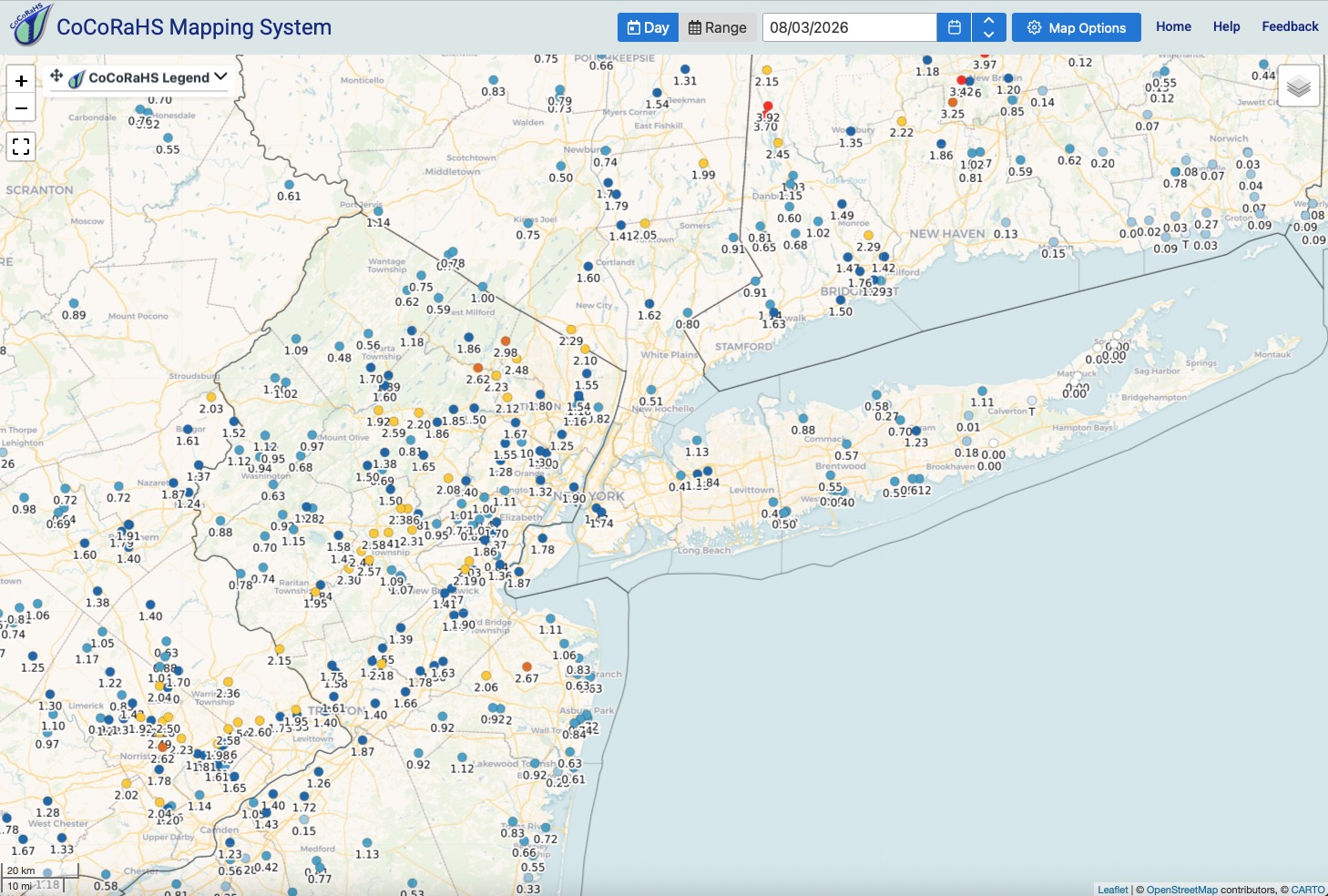
Rainfall totals through about 8am from current event. The places that have gotten the most rainfall recently continue to get soaked.
-
Augdewst 2026: Summer's Last Stand
dendrite replied to Prismshine Productions's topic in New England
Flash dating warning -
 Beaucoup de patients témoignent de leur satisfaction concernant [url=https://newsfrrx.sbs/#]obtenir des conseils sur les traitements érectiles[/url].
 -
Augdewst 2026: Summer's Last Stand
RUNNAWAYICEBERG replied to Prismshine Productions's topic in New England
Is TWives expecting just some drizzle?