All Activity
- Past hour
-
Probably more likely than normal that we see some snow. Very volatile weather pattern though
-
Icon south again basically in line with euro now.
-

December 2025 regional war/obs/disco thread
moneypitmike replied to Torch Tiger's topic in New England
Always reliable back-end snow. -
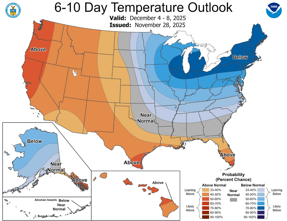
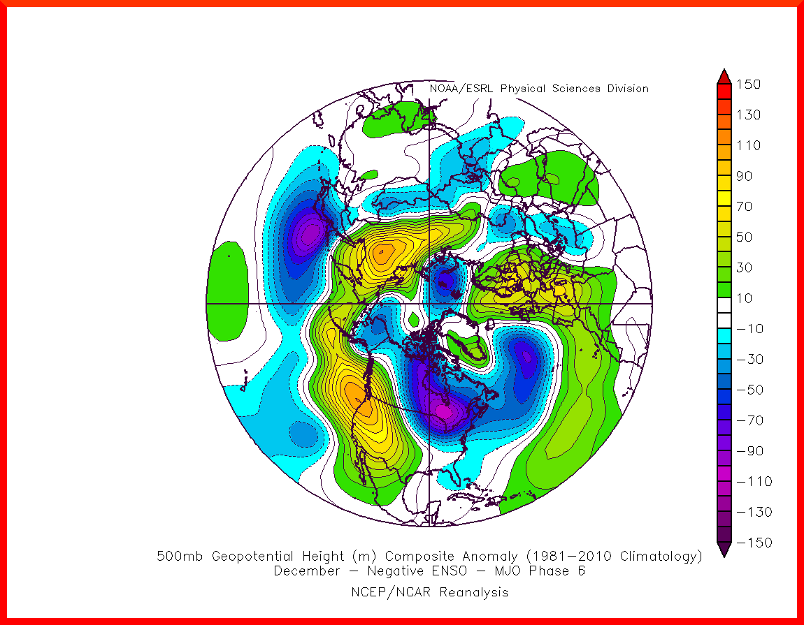
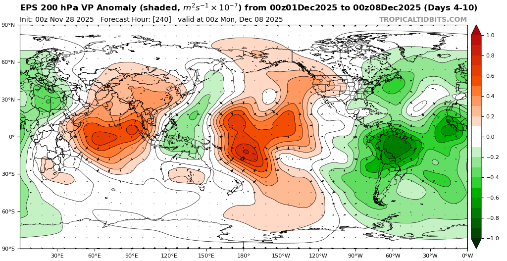
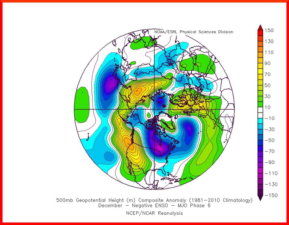
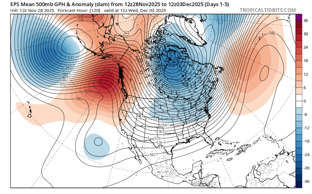
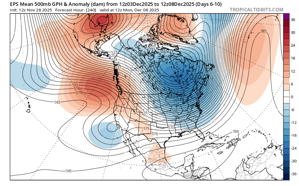
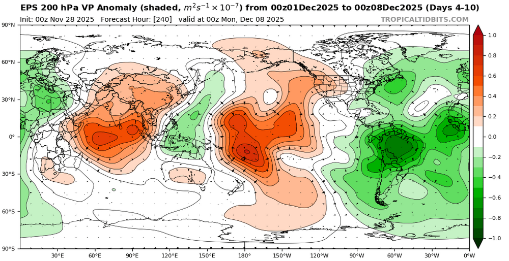
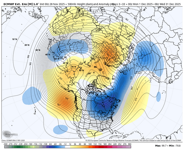
Split forcing between the Maritime Continent and the Western Hemisphere appears to be causing an interference pattern resembling a phase 6 in early December. It could also be why the models have been showing so much volatility between runs over the last week as we head into December. A Northeast Pacific +TNH with a a cold upper low centered near Hudson Bay more closely resembles a phase 6 composite. So trying to guess what composite or pattern we end up with in mid to late December is anyone’s guess at this point. We will just have to let things play out next few weeks to see which area of forcing eventually wins out.
-
You must be hating life.
-

November 2025 general discussions and probable topic derailings ...
Torch Tiger replied to Typhoon Tip's topic in New England
Snowing pretty good. -
First Winter Storm to kickoff 2025-26 Winter season
moneypitmike replied to Baroclinic Zone's topic in New England
Verbatum, this from GYX reads like it would be an 8-hour storm. I thought it was moving more slowly than that. Monday Night Mostly cloudy, with a low around 18. Tuesday Snow likely, mainly after 4pm. Cloudy, with a high near 36. Chance of precipitation is 60%. Tuesday Night Snow likely, mainly before midnight. Mostly cloudy, with a low around 23. Chance of precipitation is 70%. Wednesday Mostly sunny, with a high near 36. -
Just looking at the euro, 925 is actually out of the SW prior to the storm. Gets it to near 1c. Feel like any snow is at the tail end around here when it drops to near freezing.
-

Central PA Fall Discussions and Obs
WmsptWx replied to ChescoWx's topic in Upstate New York/Pennsylvania
US 22 W in Gallitzin is closed. Sounds like a squall blew through and collected a ton of cars. In other news, water is wet, the sky is blue, and the Eagles offense FN STINKS. -

Central PA Fall Discussions and Obs
Mount Joy Snowman replied to ChescoWx's topic in Upstate New York/Pennsylvania
Safely in New Jersey. Didn't see any flakes on the way out, thought we might. Man it’s brisk out there. -

December 2025 Short/Medium Range Forecast Thread
Matthew70 replied to John1122's topic in Tennessee Valley
Keep the flurry of posts coming. When your on a flurry it says good things usually is being shown on the models! -
Nope.
-
December 2025 Short/Medium Range Forecast Thread
Matthew70 replied to John1122's topic in Tennessee Valley
It can park there for all of January & February if like. -
BWI: 10.2" DCA: 6.7" IAD: 12.1" RIC: 5.5" Tiebreaker (SBY): 5.8"
-

Nov 28-30th Post Turkey Day Winter Storm
CheeselandSkies replied to Chicago Storm's topic in Lakes/Ohio Valley
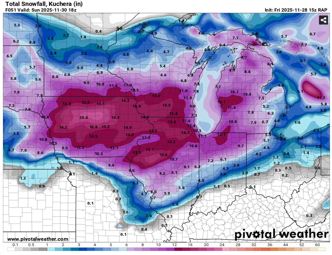
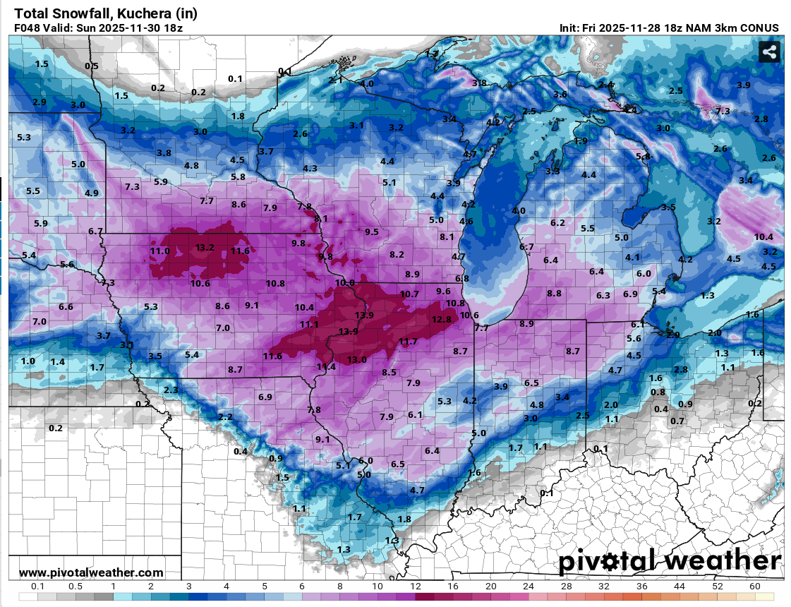
18Z 3K NAM backed off a bit from its prior few runs, down to a "mere" 8.2" for Madison by 18Z (noon CST) Sunday. Even that would be exceptional for before December 1st. However the 15Z RAP was all in on a top-end big dog with 15.5" at the same forecast hour.

-

Nov 28-30th Post Turkey Day Winter Storm
sbnwx85 replied to Chicago Storm's topic in Lakes/Ohio Valley
Potential for two top 10 November snowfalls in the same year in South Bend. Maximum 2-Day Total Snowfall for SOUTH BEND AP, IN Click column heading to sort ascending, click again to sort descending. Period of record: 1893-12-01 to 2025-11-26 1 20.5 1977-11-26 0 2 18.0 1911-11-03 1 - 18.0 1911-11-02 1 4 14.6 1977-11-25 0 5 14.3 2025-11-10 0 6 13.6 1951-11-07 0 7 13.5 1930-11-27 0 8 13.4 2014-11-14 0 9 13.0 1930-11-26 0 10 12.3 2014-11-13 0 -

December 2025 regional war/obs/disco thread
Damage In Tolland replied to Torch Tiger's topic in New England
BOX keeps insisting elevation event . Do not agree totally on that . Especially North of 90 An interior/higher-elevation mainly snow with lower-elevation/coastal plain wet, gloppy snow-to-rain scenario remains a best guess as to precipitation types; -

First Winter Storm to kickoff 2025-26 Winter season
ORH_wxman replied to Baroclinic Zone's topic in New England
Looks like it's hung up in CNE at 72h....18z Mon....we really want that further south for maintaining snow down to BOS to MMK line unless the mechanics of this change a bit. One of the things that happens if you drive the height field lower over us prior to that approaching shortwave, is that it creates more confluence when that shortwave approaches. We saw a bit of this on some prior runs a few days ago when that high was kind of sticking near CAR longer before finally retreating....I made the comment that some areas could get a good front-ender even if it flipped. The trend has been away from that for several cycles now, but if it trended even a little back toward that, it would make a huge difference....particularly for people closer to the coast and further south. I don't think it's a big deal over the deeper interior. -
Weeklies
-
Enjoy that--i only saw them once. Great show. I think it was Paul O'Neil's last tour before he died.
-

Mid to long range discussion- 2025
WinstonSalemArlington replied to wncsnow's topic in Southeastern States
-
It was more like 2.5-3 overnight here…stopped at some point then started back up around 730am. 5” measured since 930 when it was shoveled. It is really good out there. Last year thanksgiving weekend was best in years, but this is better… .
-
Cold is coming

-