All Activity
- Past hour
-
Tbh wayyy too early to speculate who is and isn’t out of it. So much will change over the next 72 hrs or so. For now let’s enjoy the trends
-

January 25/26 Jimbo Back Surgery Storm
WinstonSalemArlington replied to Jimbo!'s topic in Southeastern States
TWC rarely has North Carolina (outside of the mountains) in the sweet spot beyond the day before the event -
Maybe he’s right but he sure has missed seems like everything lately.
-

E PA/NJ/DE Winter 2025-26 Obs/Discussion
RedSky replied to LVblizzard's topic in Philadelphia Region
Carrington+single digits and teens would have froze millions -
Basically was the same run repeated. Very little difference. And that is hopefully a continuing trend.
-

Possible Record Breaking Cold + Snow 1/23 - 1/31
Nibor replied to TriPol's topic in New York City Metro
-

January 25/26 Jimbo Back Surgery Storm
SEwakenosnowforu replied to Jimbo!'s topic in Southeastern States
I grew up in New Bern...lock in in! Lol -
This is what BAM was talking about earlier in which to be some sorta inverted trough,he said the Euro was going to follow this.guess he will be disappointed,it seem the opposite is happening,good signs for us in our forum
-
Backend love. Front end dump. This event has it all. Reminds me of my days as a merchant marine.
-
-
E PA/NJ/DE Winter 2025-26 Obs/Discussion
RedSky replied to LVblizzard's topic in Philadelphia Region
We need to see a north trend at 0z -
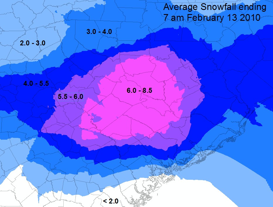
The last time I can remember a clown map giving us 12”+ within 5 days of onset we ended up with about 8” packed by a layer of sleet and ice on top, locally. That was February 12/13th 2010. The Snow stayed around for days. In spots where it had been piled up from the plows, weeks. All of the model guidance was not in agreement so local mets didn’t really sound the alarm until a day or two before.
-

Winter cancelled/uncancelled banter 25/26
WeatherGeek2025 replied to Rjay's topic in New York City Metro
i'm very superstitious, i believe i should've been the one that started the thread and everyone agreed it was too early! of course the mods let it go cause it wasnt me. I believe the thread should be deleted and if the models still have the storm on Wednesday they allow me to make the thread. @BxEngine@Rjay yes or no? im 3 for 4 this year ! -

Richmond Metro/Hampton Roads Area Discussion
Conway7305 replied to RIC Airport's topic in Mid Atlantic
Great Ensemble run
-
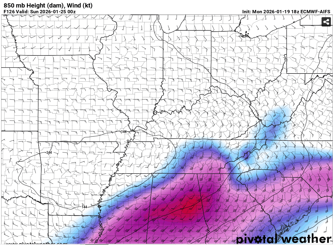
Goodness. I don't have time to dive into the differences in the 12z and 18z euro. Looks like the system is slower on the 18z? What is causing this? Forum area is pasted and still snowing across the state?!
-

January 2026 Medium/Long Range Discussion
King George Dee replied to snowfan's topic in Mid Atlantic
My favorite from 2010 . -
All the meteorologist on TV locally are saying to soon to know to not pay attention to the online chatter.
-

E PA/NJ/DE Winter 2025-26 Obs/Discussion
Ralph Wiggum replied to LVblizzard's topic in Philadelphia Region
I think he is just looking at the qpf output? Neither of those guidance tools were ever a big hit up this way....always had the main stuff South of the area thru the Del Marva. That band ticked south but precip on the Northern edge expanded/enhanced due to the new NS feature that is showing up. Reality is, we moved away from the good banding which is now well South. Maybe that will come North in future runs, but Im not so sure. -
A thought that I had earlier- if we could go back and look at the sequence of snowstorms from 1960, would it look like this on the models?
-

Possible Record Breaking Cold + Snow 1/23 - 1/31
SACRUS replied to TriPol's topic in New York City Metro
The 18Z Euro was a bit south of 12z but still had snow into the region (north of the GFS). It only is out to 144 at 18z with likely a bit more at H150/H156. -
I agree with this. These Euro runs are DGEX worthy. We used to get those regularly in winter…….
-
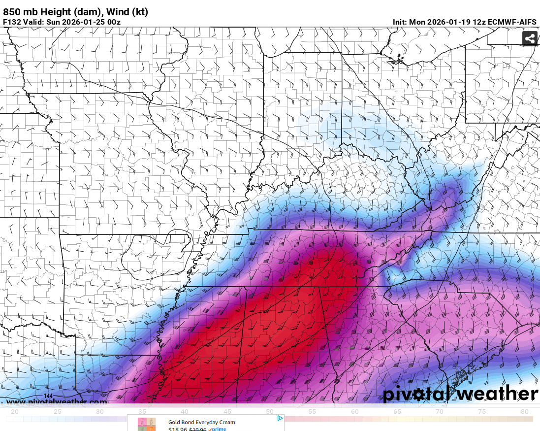
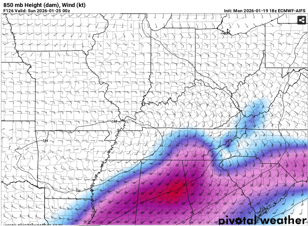
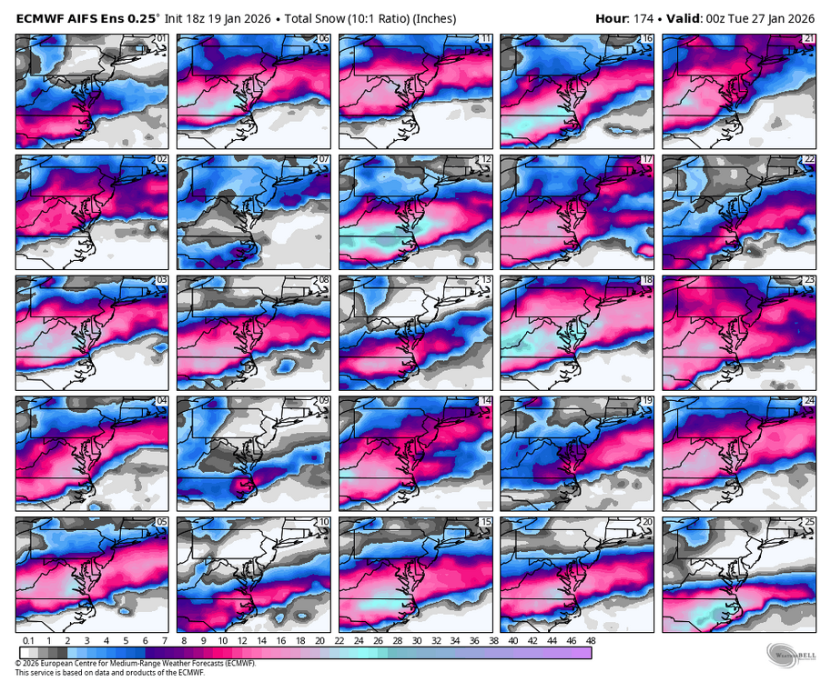
The EPS is a bit wetter and warmer, but no big changes. Jackpot zone Northern NC/the southern half of VA
-
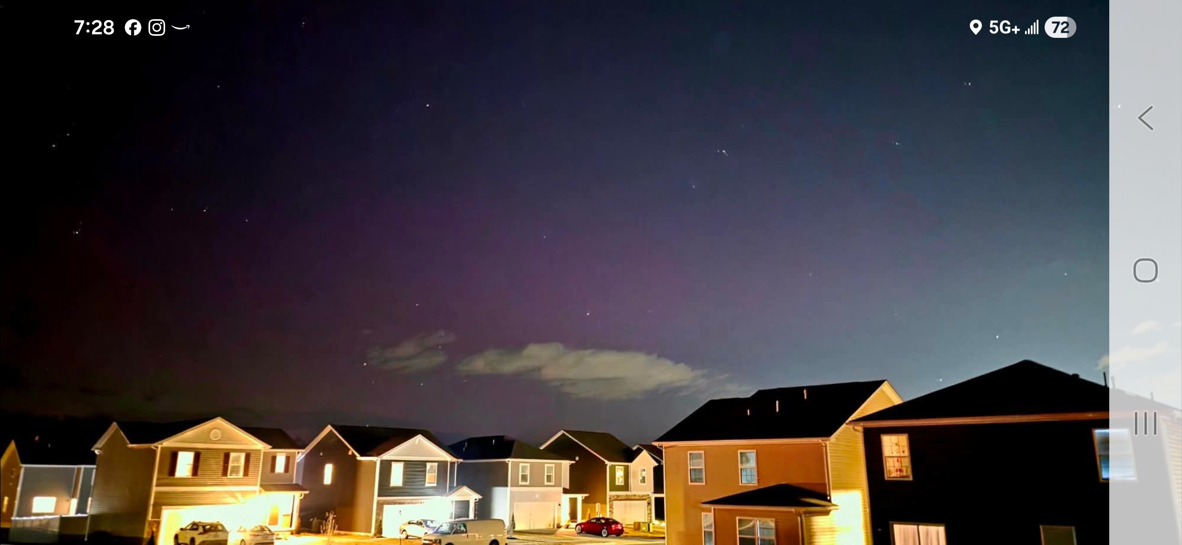
They're out. But very dim right now.

-

Pittsburgh/Western PA WINTER ‘25/‘26
Ahoff replied to Burghblizz's topic in Upstate New York/Pennsylvania
We're probably in a decent spot at this point. We know that doesn't always mean anything, but storms like this do seem to tick north as they come in. -
The FB civilians for sure will chime in with their moronic thoughts.