All Activity
- Past hour
-
an overnight low of 25 and lots of sparkly frost everywhere earlier. hope that's the end of that nonsense until the fall.
-
I tend to doubt there will be 100 degree days in July followed by 50's - the thing to be really concerned about this summer with a lack of tropical activity and El Nino is drought conditions becoming severe along the east coast
-
Scooter yesterday https://www.facebook.com/share/r/17MFfRZ1sQ/
-
Friday through Sunday looks like a heavy traffic circus in the Plains. Saturday and sometime late Sunday looks like left-overs from the Friday and Saturday Plains come through the Valley. Should be just showers, not severe, as upper energy and LLJ all eject north and/or weaken this way. Monday could be more interesting, especially if the GFS is closer to the truth. Morning wave will create complications with the instability forecast. However by Monday evening the LLJ is forecast to recover over the South with a back wave. That'd be fireworks. ECMWF is less convincing with the second wave but does have some LLJ recovery. Both have adequate speed shear and turning. Questions remain at the surface and also if the second wave is real or trash. SPC has Day 7 into the South for Monday. Even with all my concerns, late April temps often find a way to recover. (I also recall a couple times the Georgia cool wedge oozed west and cut off even Alabama). They are prudent to outlook Monday just in case.
-
Pawpaws at our frost pocket would probably fare the same as Reliant peach, which was (almost) a total failure. Hit 17° this morning, cool for late April, though we've matched it on 4/29 (twice).
-
This comes after we broke the one-day record for biggest temperature drop last month. Yep, this isn't normal. I've seen temperature swings, but not this many in such short order like we have this spring. I hope this doesn't continue. I'll even take consistent 50 or 60 degree days over this. No one wants 100-degree heat to be followed by 50-degree temps in such short order in June or July.
-
I wonder where all those bees and wasps that were out last week went ?
-
Northern Catalpa are traditionally only native to parts of the MS river valley, but they grow like weeds everywhere. Blue ash isn’t native here either, but it has shown a little more EAB resistance than green and white. Of course it could just be a preference thing and once the green and white are gone they’ll move onto the blue. Can’t help you with the beech though. Hickories and black walnut are nice shade trees, but hickories take a long time to grow. Butternut is faster, but those are diseased and dying too. The NH state forestry nursery has butternut hybrids that they sell for cheap in bulk. We need more people growing pawpaws too.
-
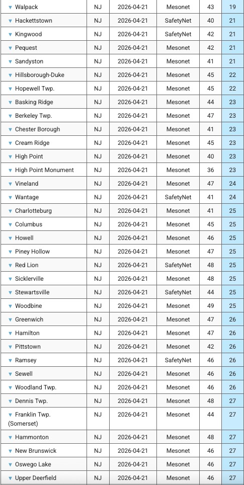
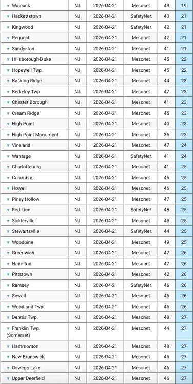
Overnight low of 25 here. Sampling of NJ overnight lows attached.
-
32.8 imby/Columbia this morning. Up to 44.3 at 10:30am.
-
Came back 20 deg so far... 24 --> 44 Pretty much 0 discernible wind ...any movement out there is closer to untouched and unknowable. With that purity of the clear sky and now late summer sun intensity, that's about as close to a 10/10 nape factor as can be found.
-
First I've read of green ash surviving. Many sources have confirmed some survival of white ash but things look grim for green and brown. In Maine (also probably elsewhere), efforts are being made to collect brown ash seeds, to fend off extirpation of this species of great importance to indigenous peoples in the Northeast. (Other than urban plantings, Maine has very few green ash.) No sign of EAB on our woodlot but it's not far away. White ash is the 3rd most abundant there, trailing only red maple and balsam fir, and brown ash is a significant component as well. I plan to have a harvest in the next few years, and would harvest all ash of sawlog/veneer quality 14"+ diameter while retaining all other ash. (The 2013 harvest included no hardwood sawlogs but took a significant volume of hardwood pulp. A second harvest would take some red and sugar maple logs along with the ash.)
-
No issues or crop damage to any of the flowers, flowering shrubs, tree leaves etc, Everything vibrant and growing . Despite being below 32 for 7 hours
-
Funny stuff
-
Hopefully .50 to 1 inch says the WPC. We really need a ton more rain as we near peak sun/heat in a couple months.
-

2026-2027 El Nino
mitchnick replied to Stormchaserchuck1's topic in Weather Forecasting and Discussion
I recall Snowman posting the BOMM at +3-3.25C in 2023 and only broke +2C for 1 trimonthly. Location of the best forcing will be what makes or breaks winter in the east this year. -
31 F even here. Open water outside were all frozen.
-
Got to 26 here. Potted plants froze through but seem to be fine this morning after a little sun. I think the garlic liked the kick in the head, it looks so happy this morning.
-
Wow big last-minute drop at my place near Leesburg. Had leveled off at 35-36 for a couple of hours and even started rising a bit, then starting at 5:30 plunged down to 32 within 90 minutes.
- Today
-
Loosing ash and beech so close together is a nightmare. We do not have ash on Long Island but tons of beech. Catalpa is the latest native leaf out tree I have seen. Latest overall is crape Myrtle, I have had multiple clients complain that they want them replaced because they are dead. But inevitably they leaf out 3 weeks after everything else. LI is about the northern extent of where they are viable. .
-
My guess is the Pope’s tomato plants got fried with a low of 27°
-
Pretty big frost and 35 at the house
-
April 21 1910: A snowstorm hits northeastern Minnesota. Duluth picks up 6.5 inches. For Tuesday, April 21, 2026 1958 - Portions of Montana were in the midst of a spring snow burst. Snowfall amounts ranged up to 55 inches at Red Lodge, 61 inches at Nye Mine, and 72 inches at Mystic Lake. (David Ludlum) 1967 - Severe thunderstorms spawned 48 tornadoes in the Upper Midwest. Hardest hit was northern Illinois where sixteen tornadoes touched down during the afternoon and evening hours causing fifty million dollars damage. On that Friday afternoon tornadoes struck Belvidere IL, and the Chicago suburb of Oak Lawn, killing 57 persons. (David Ludlum) 1980 - The temperature at International Falls MN hit 90 degrees. (The National Weather Summary) 1987 - Unseasonably warm weather prevailed from the Gulf of Mexico to New England and the Great Lakes Region, with twenty-nine cities reporting record high temperatures for the date. Afternoon highs of 82 degrees at Caribou ME, 94 degrees at Mobile AL, 95 degrees at Monroe LA, and 93 degrees at New Orleans LA, were records for the month of April. (The National Weather Summary) 1988 - After having had just twelve rainouts in the previous twenty-six years at Dodger Stadium, a third day of heavy rain in southern California rained out a double-header at Dodger Stadium which had been scheduled due to rainouts the previous two days. (The National Weather Summary) (Storm Data) 1989 - The temperature at Las Animas, CO, soared to 100 degrees to establish a state record for April. Twenty-two cities in the central and southwestern U.S. reported record high temperatures for the date. Eight cities equaled or exceeded previous April records. (The Weather Channel) (The National Weather Summary) 1990 - Afternoon and evening thunderstorms produced golf ball size hail in Oklahoma, and also caused some flash flooding in the state. Thunderstorms over the Southern High Plains produced golf ball size hail at Roswell NM and El Paso TX. Easterly winds and temperatures near zero produced wind chill readings as cold as 50 degrees below zero for the spring festival (Piuraagiaqta) outdoor events at Barrow AK. (The National Weather Summary) (Storm Data) 2007 - The South Plains and Panhandle of West Texas were hit by an outbreak of severe thunderstorms. Between the hours of 5 and 6 pm, several thunderstorms developed across the western South Plains. Around 7 pm, a supercell produced a tornado which touched down around Fieldton (southwest of Olton) and then moved just south and east of Olton, doing damage to several structures and equipment. The thunderstorm continued to move northeast across northeast Lamb, northwest Hale, southeast Castro and southwest Swisher Counties, producing a long-lived tornado (along with hail up to the size of tennis balls). By 7:45 pm, the storm approached the town of Tulia in Swisher County. A tornado touchdown was reported in the town, causing major damage. The tornadic thunderstorm continued to move northeast across Swisher County over open country through about 8:30 pm. (NWS Lubbock, TX)
-
We've actually lucked out somewhat-a fair amount of sunny days (Even if chilly) this spring and last week was a bonus.
-
Whoa our Xfinity service down in southern Calvert has been down since 8:30 last night. Says “network damage” which doesn’t sound good! Got down to 34° with some frost and now up to 47°. Waiting for 50° to put the plants back out