All Activity
- Past hour
-

September 2025 OBS-Discussion centered NYC subforum
jm1220 replied to wdrag's topic in New York City Metro
We have 10 more years I think until we can say this with confidence. We had a bonanza period that lasted about 18 years with a few duds thrown in. We were due for a sharp reversion to the mean-there's no way NYC can get away with regular 40" snow winters. So if this new regime started in 2018, that would be 2036 when we have an equally long timeframe as the snowier one. Also the background warming means marginal snow situations 30 years ago would be rain now-so the bad years are even worse. -
 Your current implied forecasts for rest of season are shown in previous post -- where it is assumed Gabrielle will become a non-major hurricane at some future point. We are past the halfway point of climatology for seasonal totals, although a few seasons can be found where this was before the halfway point (not many). Some of us are going to need a finish like 1887 to get anywhere near our forecasts. I would have to say the two forecasts scored in the table (Hotair, retrobuc) are looking like the favorites at this point.
 -
1.13" for the event total here. Side note: The evening twenty-two years ago today was a gorgeous 10/10.
-

2025-2026 ENSO
michsnowfreak replied to 40/70 Benchmark's topic in Weather Forecasting and Discussion
Exactly. I enjoy that we have people from all different areas posting. And i would expect that everyone is most concerned about their own area. But have to be careful to apply localized logic in a broadbrush sense. As I've said many times, theres no question that snow lovers in the Great Lakes would prefer a la nina any day over el nino. Of course ENSO itself is only one piece of the puzzle, but theres enough history to see what is the better enso state for the winter enthusiast in MI. Of course it will still snow here multiple times in an El Nino...but it will be a much quieter winter than a Nina. The full winter as a whole seems to hold more importance for the midwest, Lakes, and new England in terms of how we view it, whereas the coastal areas into the mid Atlantic are all about what pattern can give them a monster storm. -
Franklin Co W of the CT River is where you really start to feel disconnected from E MA. I mean, the Quabbin Hilltowns are pretty rural and isolated too but Greenfield and W is where you realize, you are not commuting distance to Boston and are not close to any populated areas. I lived in Cambridge for many years, so I still miss the restaurants and entertainment, just not the crowds and traffic.
- Today
-

2025 Atlantic Hurricane Season
dbullsfan replied to BarryStantonGBP's topic in Tropical Headquarters
I'm ecstatic nothing is happening, but this is weird right? Seems way too quiet. -
32,33 34 came up but so long ago I just leave it alone.
-

E PA/NJ/DE Autumn 2025 Obs/Discussion
Kevin Reilly replied to PhiEaglesfan712's topic in Philadelphia Region
Total rain down here in Media the other day was 0.48" not too bad actually. -
I'm moving up to Saugerties this weekend, rip to my legendary radiating hole
-

2025-2026 ENSO
so_whats_happening replied to 40/70 Benchmark's topic in Weather Forecasting and Discussion
I feel like there was a way but maybe that was a different forum I was on. So true though 100+ pages... im not going through that. CDAS almost looks representative to RONI output compared to OISST and CRW. -
Because it's hot? I like it out there, more of a laid back valley lifestyle. Even where you and I are now is kind of connected to the Boston hustle vibe. RT 2 East is packed in the AM.
-
The supposed current heat has not been a factor here. My high today was 80.4, the first day above 80. It was 54 this morning. Chilled the house with the windows open. Haven't had my AC on in almost 30 days now. Basically a late summer miracle.
-
I liked that area when I worked out there, rather live where I am now.
-
I’m planning to save on heating costs this winter by having no clouds.
-
While we're at it why don't you quantify similar. I'm willing to bet you don't mean less.
-
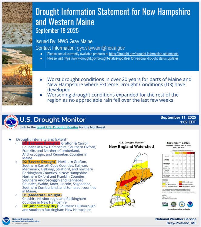
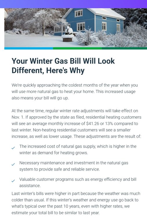
Got to love this paragraph. If I'm reading it correctly eversource, if temperatures are similar to the warmest 10-year period on the face of the Earth I'm good? "Last winter’s bills were higher in part because the weather was much colder than usual. If this winter’s weather and energy use go back to what's typical over the past 10 years, even with higher rates, we estimate your total bill to be similar to last year."
-
Eversource gas rates going up 13% on November 1st. Good thing we shut down all the solar and nearly completed wind farms. Dendrite please don't give a demerit for a semi-political comment.
- Yesterday
-
Did pick up 0.11” for a September total so far of 0.28”. Tinder dry.
-
83.8° high off a 46.2° low this morning. Just about perfect weather really. Makes me excited to practice my new fire breathing hobby in the woods out back later this evening.
-
The pattern the next two weeks will support additional cooling in the GOA with warming or at least maintenance of the warmth in the west Pacific. Beyond that who knows. But as others noted, the NE Pacific warm pool did collapse in October 2013 and didn't rebuild all the way until December. Obviously that was the result of the pattern though, rather than the SSTAs driving anything.
-
Models are all over the place for late next week but the Euro shows a deluge
.thumb.png.47cff5e5328ea10ed18146d9125eb50a.png)
-

September 2025 OBS-Discussion centered NYC subforum
donsutherland1 replied to wdrag's topic in New York City Metro
Tomorrow will be partly cloudy and unseasonably warm. Temperatures will top out in the lower 80s. The warmer spots could see some middle and perhaps upper 80s. Cooler air will return for the weekend with another warmup possible starting early next week. The ENSO Region 1+2 anomaly was -0.2°C and the Region 3.4 anomaly was -0.5°C for the week centered around September 10. For the past six weeks, the ENSO Region 1+2 anomaly has averaged +0.10°C and the ENSO Region 3.4 anomaly has averaged -0.37°C. La Niña conditions will likely develop during mid- or late-autumn. The SOI was +4.40 today. The preliminary Arctic Oscillation (AO) was -0.972 today. Based on sensitivity analysis applied to the latest guidance, there is an implied near 54% probability that New York City will have a warmer than normal September (1991-2020 normal). September will likely finish with a mean temperature near 69.3° (0.1° above normal). Supplemental Information: The projected mean would be 1.3° above the 1981-2010 normal monthly value. -
I went to the BigE today.. I don't miss living in that area at all ..
-
Well at least as a naked swirl, we can tell it has a closed circulation...... Still a lot of dry air in the area around TS Gabrielle.
-
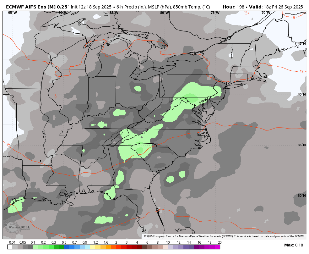
End of next week looks wet on WB AI ensemble.


.thumb.png.4150b06c63a21f61052e47a612bf1818.png)


.thumb.JPG.418e8a9a2902ae687ec35ff4bc0e038e.JPG)


.png.23664c24952c9d3db0c04fe7bfd62fa3.png)