All Activity
- Past hour
-

2025-2026 New England Snow Recordkeeping Thread
MarkO replied to bristolri_wx's topic in New England
Welp, it's currently snowing at my cabin, so time to start my season totals. -

November 2025 general discussions and probable topic derailings ...
wxeyeNH replied to Typhoon Tip's topic in New England
33.9F Moderate catpaws -
This is your winter.
-

11/8-11/10 First Snow and Lake Effect Event
homedis replied to Geoboy645's topic in Lakes/Ohio Valley
Overall short term guidance seems pretty consistent with the snow band. 12z suite came a touch west with the main band compared to 06z, but only time will tell. Nevertheless, trying to not get my hopes up too much as we know how these setups can easily pull out of NE IL and into NE IN pretty fast -

11/8-11/10 First Snow and Lake Effect Event
magoos0728 replied to Geoboy645's topic in Lakes/Ohio Valley
If any of this verifies in lakeshore areas around the city, the mess it'll cause will be off the charts. I lived in Cobb County GA during a early December snowstorm and it took down power lines across the area. The night of the snowfall was lit up by transformers blowing across the area -

November 2025 general discussions and probable topic derailings ...
dryslot replied to Typhoon Tip's topic in New England
Speaking in front of an empty chalice. -

11/8-11/10 First Snow and Lake Effect Event
A-L-E-K replied to Geoboy645's topic in Lakes/Ohio Valley
Taking the under
-

11/8-11/10 First Snow and Lake Effect Event
Chicago Storm replied to Geoboy645's topic in Lakes/Ohio Valley
The problem re: Chicago snowfall records… The core of activity will likely be east of ORD. So, in the end, it may be tough to see any sort of record falls, unless best activity is surprisingly further west. Orientation may even keep MDW out of the absolute best as well, but we’ll see. Better shot there than ORD. Of course, nothing there would be official, but it would be documented at least. -

Mid to long range discussion- 2025
WinstonSalemArlington replied to wncsnow's topic in Southeastern States
There’s a chance -

11/8-11/10 First Snow and Lake Effect Event
Brian D replied to Geoboy645's topic in Lakes/Ohio Valley
I've been having snow shwrs in my area since yesterday. Dusting in town this morning. -

November 2025 general discussions and probable topic derailings ...
SJonesWX replied to Typhoon Tip's topic in New England
aside from yesterday, what day(s) have been “warm”? -

Fall 2025 WX Discussion Thread
Save the itchy algae! replied to Carvers Gap's topic in Tennessee Valley
Sounds like the local office is going to expand advisories in the pm update. We’ll see! Getting my leaves situated by the road hoping the cold front blows them down the street later.. . -
The current and recent KCHS NWS forecasts for KSAV have been for 30 on 11/11 in a windy freeze. If that were to verify, it would be the earliest 30 or colder since way back in 1976! However, latest and recent model consensus is suggesting that 30 is on the low end (Icon). ICON actually warmed some from 27s on Sat runs. Latest ICON/GFS/CMC/Euro/UKMET (through 6Z/0Z 11/9 runs) have 30/32/33/33/34. If this were a radiational cooling night, I’d likely favor the low end per slight warm bias of consensus. But with it being windy, I’m currently thinking near the model avg of 32. However, if the model consensus were to cool, I’d adjust colder. Even just getting to 32 would mean the earliest freeze since 2010!
-
Beautiful day again
-
Yeah it’s a different way of getting there time around because geomag activity is high, not low like it was in 2010. It is my understanding that the expected polar vortex intrusion is being driven by the -QBO (2010 was +QBO) and low North Atlantic sea ice instead. The main reason I like 2010 as an analog though is I see similar potential for the -NAO to amplify the La Niña pattern, leading to a stormy and snowy pattern for northern areas (miller B storm track).
-
November 2025 general discussions and probable topic derailings ...
dryslot replied to Typhoon Tip's topic in New England
-SN, Graupel mix, 37.2F, First flakes of the season. -
Snowman, Please clarify when you say models were showing an amplified 8-1-2 MJO last Dec: -What were the approximate dates of model runs you are referring to? And which models? -For around what dates are you saying these runs projected an amplified 8-1-2? (Aside: I generally concentrate on following only the GEFS/EPS and even they aren’t reliable. I describe them as the least unreliable with GEFS being better than EPS, especially Maritime/W Pac. Lately they’ve been too fast in their progs through phase 6 into 7 and with EPS not having enough amplitude, a common problem of it in those regions.)
-

11/8-11/10 First Snow and Lake Effect Event
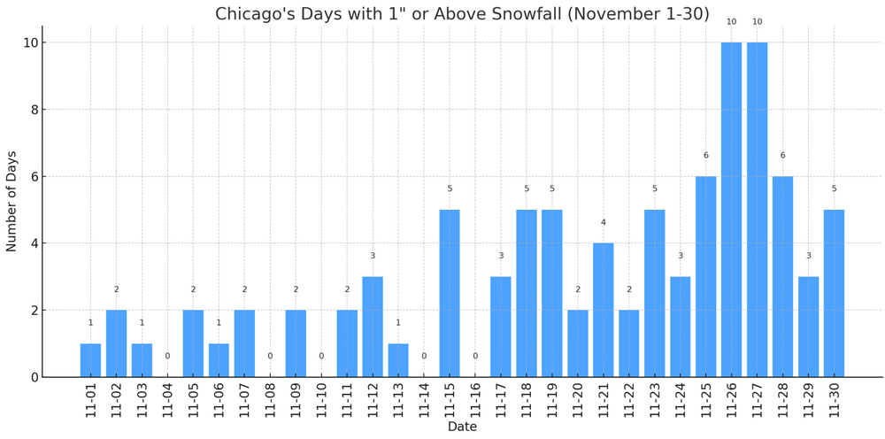
donsutherland1 replied to Geoboy645's topic in Lakes/Ohio Valley
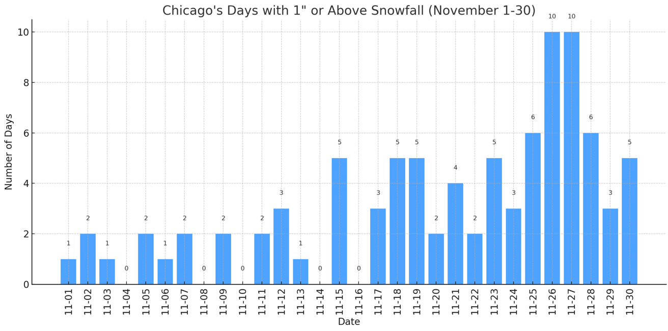
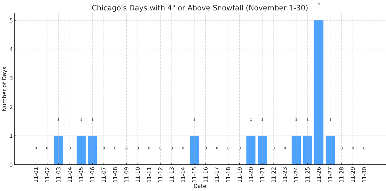
For reference, some historic data for Chicago: Frequency Data for Select November Daily Snowfall Amounts: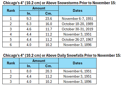

-

November 2025 general discussions and probable topic derailings ...
Brewbeer replied to Typhoon Tip's topic in New England
-

11/8-11/10 First Snow and Lake Effect Event
Chicago916 replied to Geoboy645's topic in Lakes/Ohio Valley
Can't remember seeing "snow and a chance of thunderstorms" in a p&c before. Was laughing thinking about nadocast outlining the shore during the event in a forecast, but I'm sure waterspouts are filtered out from forecasts. -

Central PA Fall Discussions and Obs
Superstorm replied to ChescoWx's topic in Upstate New York/Pennsylvania
Good for Lakes Region. Could see some significant LES. Not good climo period for us. We will probably be on warm side after that period 3 to 4 week period, as climo improves. . -

11/8-11/10 First Snow and Lake Effect Event
hawkeye_wx replied to Geoboy645's topic in Lakes/Ohio Valley
The warmer models were correct for my area. I did not see a single flake. -

11/8-11/10 First Snow and Lake Effect Event
nwohweather replied to Geoboy645's topic in Lakes/Ohio Valley
What a surprise 2” here in Toledo! -

Central PA Fall Discussions and Obs
Mount Joy Snowman replied to ChescoWx's topic in Upstate New York/Pennsylvania
And just like that it is absolutely dumping here. -
Mid to long range discussion- 2025
WinstonSalemArlington replied to wncsnow's topic in Southeastern States
HRRR