All Activity
- Past hour
-
Pattern reversal is pretty amazing
-

December 2025 Short/Medium Range Forecast Thread
Golf757075 replied to John1122's topic in Tennessee Valley
Each winter is different than other winters in some ways. That's the reality of it. The trough has been too far east for my area to see anything other than glancing blows of cold air. We definitely need a pattern reshuffle I believe. -

December 2025 regional war/obs/disco thread
WxWatcher007 replied to Torch Tiger's topic in New England
Just about everyone does olympic level mental gymnastics during the winter from southeast Canada to Georgia. People are overly pessimistic just as they are overly positive depending on where they sit and how desperate they are for snow. Like you said, that's the purpose of the board, and it's what makes it incredibly fun and incredibly frustrating all season long. Most people strike enough of a balance to fit in, but we have our positive and negative outliers--God love (most of) 'em, no doubt about it. My perspective has always been--just have fun. If you're negative, have fun with it. If you're a #faithinflakes kind of person, make it entertaining not obsessive. If you don't believe in fun, be educational at least. Life is far too short and serious to be miserable here. -
Well that’s quite the torch eh? That would make me drive to Greensboro Monday instead for my Xmas eve seafood. .
-
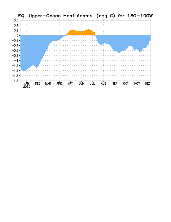
OHC has been rising sharply the last 30 days:
-
In the last 30 years at DCA there have been 12 below average Dec. In last 30 there have been four at -5 or colder:1995, 2000, 2005 2010. Notice how in blocks of five and perhaps again this year
-
Interesting stats! Obviously it has felt like the coldest start to winter in a number of years, but it's impressive that this prolonged snow cover is so rare for this early in the season. 2010-11 was quite a winter...
-
The car washes are gonna look like Walmart on black friday tomorrow.
-

Mid to long range discussion- 2025
WinstonSalemArlington replied to wncsnow's topic in Southeastern States
-
If we have a tanked PNA, that raises the likelihood the SE ridge will link up with any -NAO block which obviously is a disaster.
-

December 2025 regional war/obs/disco thread
weatherwiz replied to Torch Tiger's topic in New England
It's basically trying will things to happen which look bad. Trying to find ways in which it will work. 99% of forecast models could show a rain storm at D6 and one model showing potential for all snow...all the focus would be on how that one model "could verify" over what the actual situation is I mean...I'm not complaining about this, that's why we're all here and it's the purpose of the board...it's a discussion board lol. But it does I think yield in blending the line of fantasy versus reality at times. -
Great to have it during the lowest sun angle of the year too so we’re not losing much of it every day like in March.
-
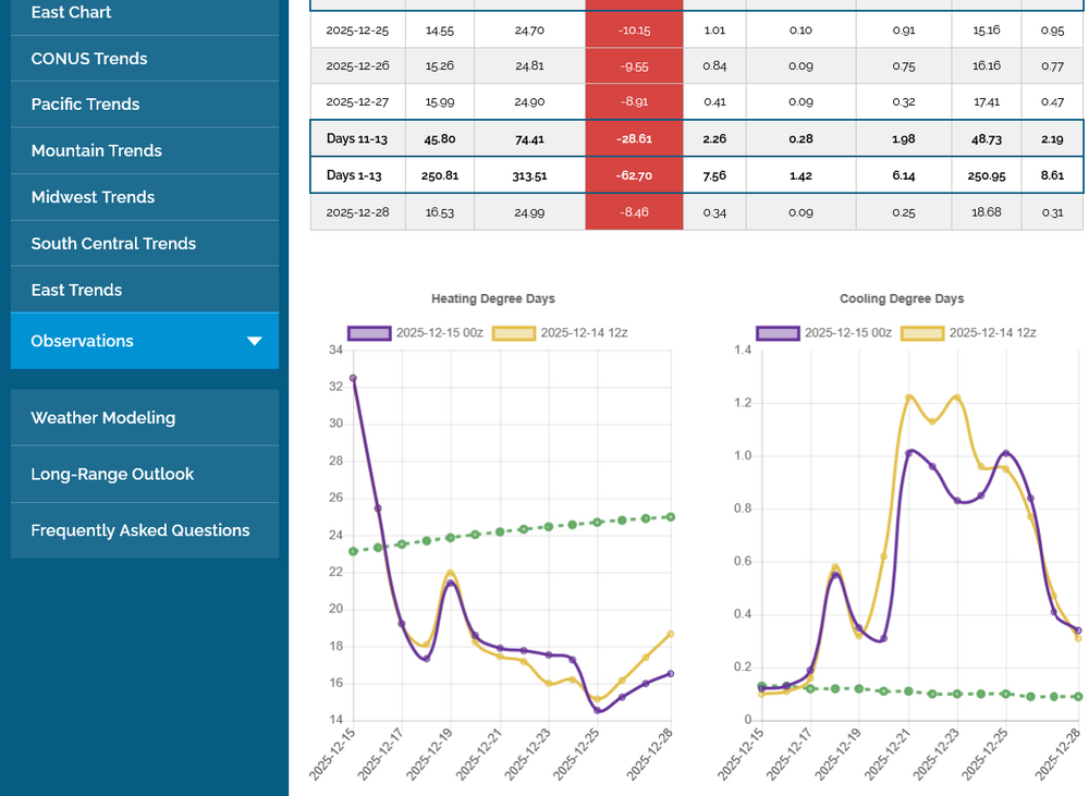
Yeah, unfortunately here’s the ugly truth for E US cold preferrers (NG is down another 1% today making it a whopping 26% drop from the peak 11 days ago): left graph has EPS HDD (latest out/0Z in purple); note the cliff dive it takes from today’s very cold 33 HDD, which is a whopping 10 above the normal of 23, to 12/18’s mild 18, which is 6 below the normal of 24! It later gets as low as 15 on 12/25, which is 10 below the normal of 25!
-
A week before solstice and cloud cover is keeping it cool. We're barely reaching SW/LW equilibrium.
-
December 2025 regional war/obs/disco thread
weatherwiz replied to Torch Tiger's topic in New England
If things unfolded as advertised, I wouldn't be surprised if we had a decent chance of throwing more moisture our way given the southwesterly flow around the stout high across the southeast. However, I think what we would really want to see is a deamplifying wave like you said...or even a strong Arctic cold front plowing southeast across the Plains which would help tap into the Gulf. What would be excellent if there was a connecting the the equatorial PAC...we would be golden I think there -
Heck yea. This cool stretch has been legit impressive.
-

December 2025 regional war/obs/disco thread
TauntonBlizzard2013 replied to Torch Tiger's topic in New England
Yeah, I’m not going to argue anymore, but is 100% the truth. There would be posts talking about how it fits the pattern, etc. I mean, let’s just be honest about what’s really happening. People don’t want to discuss the potential negative outcomes, it’s as simple as that. -
Temperatures seem to be on the low side of guidance. Still only 27 near me at 1pm.
-

Pittsburgh/Western PA WINTER ‘25/‘26
RitualOfTheTrout replied to Burghblizz's topic in Upstate New York/Pennsylvania
Yes, at least one I remember actually happened on Christmas Eve. Wave developed along a front, front went through, temps dropped and rain turned to snow as the developing wave stalled the front. -
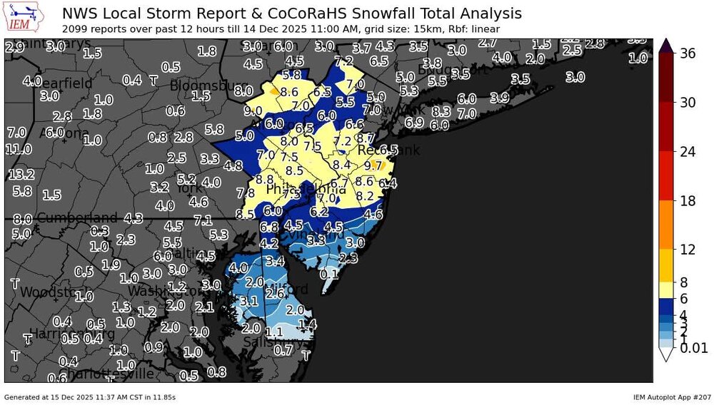
Mid-December has been prime time for snow across the region since 2011. Time Series Summary for NEWARK LIBERTY INTL AP, NJ 12-01 to 12-10 snowfall Click column heading to sort ascending, click again to sort descending. 2025-12-10 0.1 0 2024-12-10 T 0 2023-12-10 T 0 2022-12-10 T 0 2021-12-10 T 0 2020-12-10 0.5 0 2019-12-10 2.5 0 2018-12-10 T 0 2017-12-10 4.3 0 2016-12-10 T 0 2015-12-10 0.0 0 2014-12-10 0.1 0 2013-12-10 3.1 0 2012-12-10 0.0 0 2011-12-10 0.0 0 Time Series Summary for ISLIP-LI MACARTHUR AP, NY 12-01 to 12-10 snowfall Click column heading to sort ascending, click again to sort descending. 2025-12-10 T 0 2024-12-10 T 0 2023-12-10 T 0 2022-12-10 0.0 0 2021-12-10 T 0 2020-12-10 T 0 2019-12-10 1.9 0 2018-12-10 T 0 2017-12-10 1.3 0 2016-12-10 0.0 0 2015-12-10 0.0 0 2014-12-10 0.1 0 2013-12-10 1.6 0 2012-12-10 0.0 0 2011-12-10 T 0 Time Series Summary for NEWARK LIBERTY INTL AP, NJ 12-11 to 12-20 snowfall Click column heading to sort ascending, click again to sort descending. 2025-12-20 4.1 6 2024-12-20 0.3 0 2023-12-20 0.0 0 2022-12-20 0.1 0 2021-12-20 0.0 0 2020-12-20 11.4 0 2019-12-20 1.7 0 2018-12-20 T 0 2017-12-20 2.8 0 2016-12-20 3.4 0 2015-12-20 0.0 0 2014-12-20 0.2 0 2013-12-20 6.3 0 2012-12-20 0.0 0 2011-12-20 0.0 0 Time Series Summary for ISLIP-LI MACARTHUR AP, NY 12-11 to 12-20 snowfall Click column heading to sort ascending, click again to sort descending. 2025-12-20 5.8 6 2024-12-20 T 0 2023-12-20 0.0 0 2022-12-20 0.4 0 2021-12-20 0.0 0 2020-12-20 7.5 0 2019-12-20 2.3 0 2018-12-20 T 0 2017-12-20 3.4 0 2016-12-20 3.2 0 2015-12-20 0.0 0 2014-12-20 0.3 0 2013-12-20 4.8 0 2012-12-20 0.0 0 2011-12-20 0.0 0 Time Series Summary for NEWARK LIBERTY INTL AP, NJ 12-21 to 12-31 snowfall Click column heading to sort ascending, click again to sort descending. 2024-12-31 3.2 0 2023-12-31 0.0 0 2022-12-31 T 0 2021-12-31 0.1 0 2020-12-31 0.0 0 2019-12-31 0.0 0 2018-12-31 T 0 2017-12-31 0.6 0 2016-12-31 T 0 2015-12-31 0.3 0 2014-12-31 T 0 2013-12-31 T 0 2012-12-31 1.9 0 2011-12-31 0.0 0 Time Series Summary for ISLIP-LI MACARTHUR AP, NY 12-21 to 12-31 snowfall Click column heading to sort ascending, click again to sort descending. 2024-12-31 2.1 0 2023-12-31 0.0 0 2022-12-31 0.0 0 2021-12-31 0.3 0 2020-12-31 0.0 0 2019-12-31 0.0 0 2018-12-31 T 0 2017-12-31 1.3 0 2016-12-31 0.0 0 2015-12-31 T 0 2014-12-31 0.0 0 2013-12-31 1.7 0 2012-12-31 0.6 0 2011-12-31 0.0 0
-

December 2025 regional war/obs/disco thread
weathafella replied to Torch Tiger's topic in New England
Ok op huggers-today’s euro is snowy for many of us. -
Bamwx's video out today supports that and the return to winter. Coincidentally, the video shows exactly what I posted yesterday to Larry that this Friday's cold front wasn't on modeling several days ago.
-

December 2025 regional war/obs/disco thread
SouthCoastMA replied to Torch Tiger's topic in New England
Its been advertising snow around that time, off and run, for the past several days. Oh wait, I'm breaking the rule of talking about long range OP runs. -
with respect to that surface hp around the 22nd/23rd, there isn't much to suggest we're gonna run a big moisture plume into it right now and even a 6z gfs front ender doesn't have a lot of support at this time (including from 12z). But maybe a deamplifying wave of some kind could be in play on the front side of the ridge going up in the center of the CONUS. Normally that's not gonna excite most people, but could be the difference in a white Christmas for some.
-