All Activity
- Past hour
-

1/24-1/25 Major Winter Storm - S. IL, IN, and OH
Baum replied to A-L-E-K's topic in Lakes/Ohio Valley
Not a model guy, but not seeing that. Showed a shade of blue over my house for about 10 hours same as last run. -

Possible Record Breaking Cold + Snow Sunday 1/25 - Tuesday 1/27
Neblizzard replied to TriPol's topic in New York City Metro
Because Upton is going with 10-14 inches with some mixing and the latest guidance has trended warmer. That’s all I’m saying. -

Pittsburgh/Western PA WINTER ‘25/‘26
Rd9108 replied to Burghblizz's topic in Upstate New York/Pennsylvania
-

Possible Record Breaking Cold + Snow Sunday 1/25 - Tuesday 1/27
MJO812 replied to TriPol's topic in New York City Metro
Quite possible -

January 25-26 Winter Storm Potential
Birds~69 replied to Ralph Wiggum's topic in Philadelphia Region
It made zero sense but I just let it go... -

Jan 24-26 Weekend Snow and Sleetfest Model Thread Part Tres
mitchnick replied to H2O's topic in Mid Atlantic
At 39hrs, the 12k has a 1007 slp in central Mississippi, yet it just punch the sleet line thru mby like a hot knife thru butter some 1000+ miles away. Pretty crummy long wave pattern that we can't keep this storm from turning nasty. -
Pittsburgh/Western PA WINTER ‘25/‘26
Rd9108 replied to Burghblizz's topic in Upstate New York/Pennsylvania
Primary is a tad weaker & SE of 18z. Gives the PIT crew a little more breathing room. Unfortunately doesn't help the coast much this run. From another met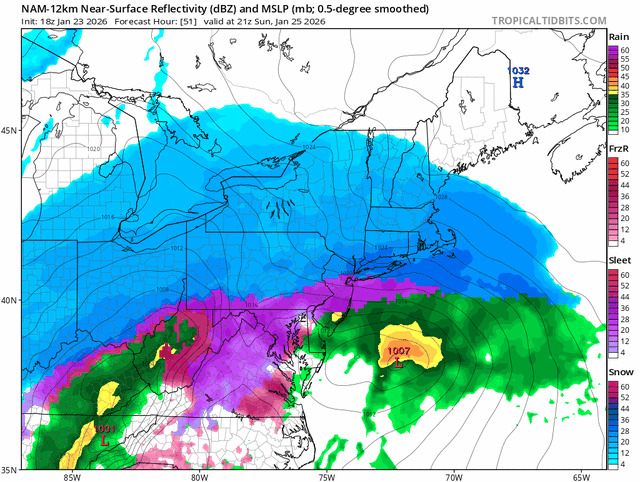
-

Possible Record Breaking Cold + Snow Sunday 1/25 - Tuesday 1/27
Jt17 replied to TriPol's topic in New York City Metro
Nah. NAM is overdoing the sleet the last 2 runs. FYI it's basically the same as last run not worse contrary to the comments I'm seeing. . -

Jan 24-26 Weekend Snow and Sleetfest Model Thread Part Tres
DDweatherman replied to H2O's topic in Mid Atlantic
The model war will definitely continue into the final day, willing to bet. -

Jan 24-26 Weekend Snow and Sleetfest Model Thread Part Tres
psuhoffman replied to H2O's topic in Mid Atlantic
Trick, the FV3 is almost always similar to the gfs inside 48 hours. Similar to the rgem/ggem. So if you want to know about what the gfs is going to look like just look at the FV3 now. -

Possible Record Breaking Cold + Snow Sunday 1/25 - Tuesday 1/27
allgame830 replied to TriPol's topic in New York City Metro
Those rates right to the north of the mix would be insane… like 2-3” an hour -
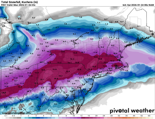
NAM continuing to show the dry slot. Also has a nice little line of rain going through Raleigh at the end lol
-

Possible Record Breaking Cold + Snow Sunday 1/25 - Tuesday 1/27
weatherpruf replied to TriPol's topic in New York City Metro
I’m confused too… I would consider 3-6 a big letdown but not 8-12. Now I’m on record not buying 8–12. But I would consider it a good storm. -

Jan 24-26 Weekend Snow and Sleetfest Model Thread Part Tres
clskinsfan replied to H2O's topic in Mid Atlantic
3K was a step back. Is what it is. -

Jan 24-26 Weekend Snow and Sleetfest Model Thread Part Tres
Maestrobjwa replied to H2O's topic in Mid Atlantic
Very poor. I mean they wouldn't even be close! This one falling apart in the last 36 hrs would be brutal... -

January 24-26: Miracle or Mirage JV/Banter Thread!
LeesburgWx replied to SnowenOutThere's topic in Mid Atlantic
If the NAM is correct, the public will have pitchforks out for all the Mets instead of the apps -

Possible Record Breaking Cold + Snow Sunday 1/25 - Tuesday 1/27
Wxbear25 replied to TriPol's topic in New York City Metro
The surface is a reflection of the upper-levels, not vice-versa. The strength and positioning of that wave is what will dictate the primary/secondary strength and transition as well as the strength of mid-level features which is what is driving the warming, not the surface feature. -

Possible Record Breaking Cold + Snow Sunday 1/25 - Tuesday 1/27
Metasequoia replied to TriPol's topic in New York City Metro
Freezing rain isn't so much fun. However, I think of sleet as low ratio snow that helps keep the snow pack around longer. -

“Cory’s in LA! Let’s MECS!” Jan. 24-26 Disco
DavisStraight replied to TheSnowman's topic in New England
A tick of a tick. -

Pittsburgh/Western PA WINTER ‘25/‘26
Mailman replied to Burghblizz's topic in Upstate New York/Pennsylvania
Snowmap is juiced up. -

Central PA Winter 25/26 Discussion and Obs
paweather replied to MAG5035's topic in Upstate New York/Pennsylvania
Ridin with the GFS until I can’t -

1/24-1/25 Major Winter Storm - S. IL, IN, and OH
mimillman replied to A-L-E-K's topic in Lakes/Ohio Valley
-
Possible Record Breaking Cold + Snow Sunday 1/25 - Tuesday 1/27
MJO812 replied to TriPol's topic in New York City Metro
6-10 is my call -

Jan 24-26 Weekend Snow and Sleetfest Model Thread Part Tres
Amped replied to H2O's topic in Mid Atlantic
The 2017 storm had a pesky warm layer around 800mb which caused the sleet line to be way north. -

MO/KS/AR/OK 2025-2026 Winter Discussion
MUWX replied to stormdragonwx's topic in Central/Western States
Already some mPING reports in NW AR and NE OK. Seems those areas might be moistening faster than expected.


