All Activity
- Past hour
-
My pont forecast shows: .61 total FR 2.3" snow Sleet is not totaled but happens from 7am sat- 4pm Sun.
-
Again 1 run. We will track until the day of if we have to.
-
Fairly sure we have a rule here about no cliff-diving/dramatics LOL! Reel it in!
-

“Cory’s in LA! Let’s MECS!” Jan. 24-26 Disco
40/70 Benchmark replied to TheSnowman's topic in New England
19"...I got OES assist. -
My memory's not what it used to be by far but if they do get expanded N and NE has there ever been a time that much of the country was under winter storm watches/warnings at once? Nearly 40 years by my recollection but what do I know lol.
-

Possible Record Breaking Cold + Snow Sunday 1/25 - Tuesday 1/27
nycwinter replied to TriPol's topic in New York City Metro
many years ago in nyc like 15 at least we had a 12 hour sleet storm in nyc temps in low 20's and nothing but sleet covered the sidewalks and streets and everything was covered in ice and very slippery.. -
I don't think this is going to match 12/24/25 here although it could be close if we keep up this trend.
-
Hope to God those ZR totals do not verify. I mean even half of that is absolutely devastating with surface temps that low.
-
The good or bad thing about local climates.
-

2025-2026 Fall/Winter Mountain Thread
kvegas-wx replied to Buckethead's topic in Southeastern States
We've lost the patient, doctor. She didn't even have a name yet. Next! -
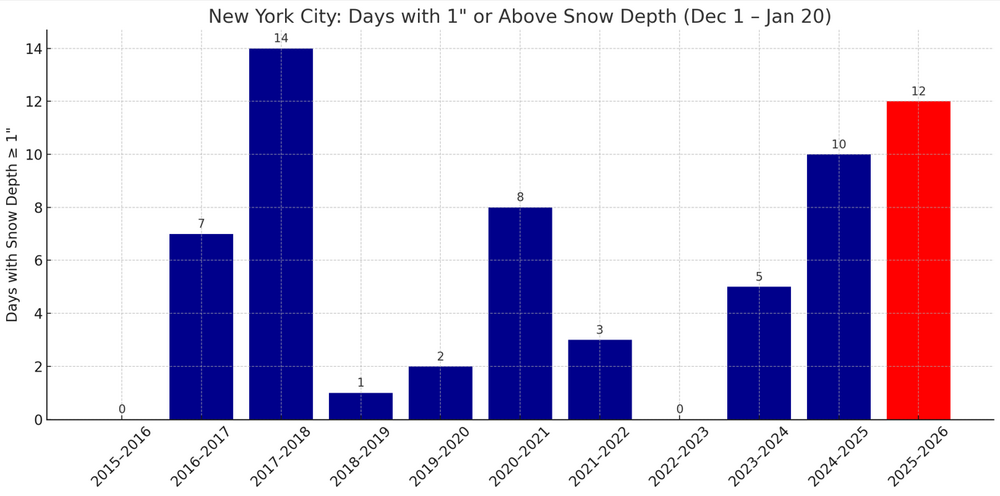
For those tracking snow cover, New York City has had the most days with 1" or above snow cover since Winter 2017-2018 through January 20th.
-
Andy any snow cover may make it difficult to get those temps above freezing. Yes...I had just posted the same thing. Good catch.
-

2025-2026 Fall/Winter Mountain Thread
Maggie Valley Steve replied to Buckethead's topic in Southeastern States
No new data from RECON until tomorrow. -
It’s all that damn farting from the mid-Atlantic people that caused this warm air.
-

Possible Record Breaking Cold + Snow Sunday 1/25 - Tuesday 1/27
dseagull replied to TriPol's topic in New York City Metro
If the north trend stops or shifts back south 50 miles, I agree with you. Toms river would do OK. Could very well see the warm nose come to fruition, though... and that would be pretty brutal. -

Possible Record Breaking Cold + Snow Sunday 1/25 - Tuesday 1/27
Jt17 replied to TriPol's topic in New York City Metro
Euro AI is a lot more like GFS and GFS AI hopefully a sign Euro is a little too quick and amped . -
but day drinking is the best
-

Possible Record Breaking Cold + Snow Sunday 1/25 - Tuesday 1/27
EastonSN+ replied to TriPol's topic in New York City Metro
27 inches from Fairfield CT to Greenwich CT. -
Yea you usually see these either miss the complete phase and slide more SE like the gfs, or you get a complete phase and wagons west. . More times than not, you get the former. West of apps or well east, no in-between track. Also the models struggle with phasing as we saw with the last storm that surprised the Detroit area and gave Toronto a foot plus. So many things have to go right timing wise so I'd guess we get more of a gfs track.
-
Euro has 2 miller B teases after this weekend
-
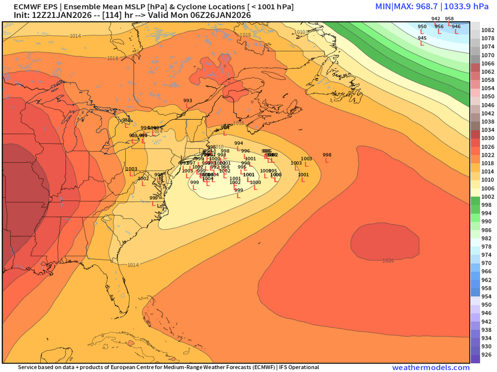
12z EPS has a big cluster to the west of the mean from the 06z run.
-
I would strongly suggest you all also use the ensembles. They have some interesting things embedded...a bit more snow. The 12z EPS shifted the snow axis about 1.5 counties south. The beginning of the Euro was also colder...sometimes the beginning of the scenario is more accurate due to it being closer in time...if it continues to cool and move precip southward near the start time in Texarkana...could be a sign the model is adjusting on the fly. We have seen that entry point into our forum change like that....and it has big implications down stream. I think for NE TN, we see 2-3" of snow followed by ice...know your microclimate. Also, interestingly....models are not showing a lot of mercy to the foothills regions w/ downslope.
-
Three(3) for me. And highs of 33 and 34 on Monday and Tuesday under full sun. Whatever falls will have staying power.
-

“Cory’s in LA! Let’s MECS!” Jan. 24-26 Disco
TheSnowman replied to TheSnowman's topic in New England
You don’t get to sit next to the stars, only the stars can. I sit in the Front row for the premieres. but the 8pm show You all see ids only about 4% of the Grammy Awards. And when it’s an honor to be a voting member + it’s $1000 for the tickets even though Only members can go + you make some lucky girls life by being able to go, YOU GO. I’ll be home ALL OF FEBRUARY. Was home the past 2 1/2 Months. I don’t know what more I’m supposed to do. -

Pittsburgh/Western PA WINTER ‘25/‘26
MikeB_01 replied to Burghblizz's topic in Upstate New York/Pennsylvania
EPS(24).thumb.png.c0a5eae6978fb7e58f5de9763dab9128.thumb.png.7a1ba7ff78576acf573f8fae8b5e0d21.png)


(24).thumb.png.c0a5eae6978fb7e58f5de9763dab9128.png.9a759d98c0f2a796ad3a810c15f0fcc9.png)