All Activity
- Past hour
-

2025-2026 ENSO
PhiEaglesfan712 replied to 40/70 Benchmark's topic in Weather Forecasting and Discussion
If Philly, Baltimore, and DC don't get a major snowstorm in the next week, a new low 10-year rolling snowfall record will be set in those places. The 2016 snowstorm officially goes off the books on Saturday. -

Storm potential January 17th-18th
WestBabylonWeather replied to WeatherGeek2025's topic in New York City Metro
I went Xmas Eve morning to get trays for dinner. Wasn’t a bad experience. In and out -
Storm potential January 17th-18th
WestBabylonWeather replied to WeatherGeek2025's topic in New York City Metro
Hopefully for round 2 it’s colder -
As I mentioned yesterday it's frustrating how condescending and arrogant he can be, but he knows his stuff. He's also from Parkton (near Fayetteville, NC) so he had a whole childhood to ponder SE snow fails. That said I think it speaks well of NC weather weenies in general in that many of us, including many of us on this forum, knew that this was very unlikely to pan out and reacted accordingly. This is actually a very interesting case of NWP failure. We rightly disparage the GFS, but in this case I'd say it had the overall idea more correct that the Euro on average. Yeah the GFS bounced around like a drunk person playing Mariocart but the rock-solid Euro was rock solid wrong in the sense that it was showing no snow because it never brought the precip back NW until the very end. And when it did, it showed the same phantom snow that the GFS did. The NAM suite was so lost and will probably insist I got snow six hours after the storm is past. Oddly, the usually snow-happy CMC was probably the miost consistently correct at range in that it long showed a warm NW track. I would love to have a long convo with a NWP expert to try and understand why the models always overestimate the speed of cold fronts in general, and always fail to resolve the Apps specifically.
-
It’s 33-it’ll be tough to do much with lighter rates.
-
Yes, Larry. We definitely had a couple of rounds of moderate to borderline heavy snow. Changeover happened just before 8 AM so we ended up with about a two hour window of snowfall. 3/4” appears to be the final total here in Perry. Still snowing lightly, but shouldn’t add much to the accumulations as the back edge is knocking on our door. Yesterday’s warm temperatures definitely created a challenge for accumulations. Our high yesterday was 62°!
-
Back and forth 42-43F since last night.
-
Biggest I’ve seen so far: 2.5” Cuthbert, WNW of Albany, GA!0932 AM SNOW CUTHBERT 31.77N 84.79W 01/18/2026 M2.5 INCH RANDOLPH GA BROADCAST MEDIA AVERAGE OF SNOWFALL FROM SEVERAL MEASUREMENTS.
-
I’m in brightwaters, and it’s still snowing, not raining. Granted it’s not accumulating
-
Damn, so long in one place.
-

Rise of the Machines: January 18-19 Winter Storm Obs Thread
HoarfrostHubb replied to WxWatcher007's topic in New England
This is from yesterday. Great looking snow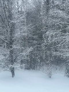
-

Storm potential January 17th-18th
Northof78 replied to WeatherGeek2025's topic in New York City Metro
Anyone in SW Essex or NW Union counties with a new snow report? -
I haven't seen any snow and was outside for the last hour or so. Perhaps early morning? On the positive side, there were a few patches of snow/graupel left from yesterday's event.
-

Pittsburgh/Western PA WINTER ‘25/‘26
Ahoff replied to Burghblizz's topic in Upstate New York/Pennsylvania
To be fair the GFS was getting laughed at for showing us getting 6 feet, not 6 inches, lol. -

First Legit Storm Potential of the Season Upon Us
weatherwiz replied to 40/70 Benchmark's topic in New England
If referring to bufkit, both are separate. If you’re using cobb11 it’s deriving the snow ratios from 5 or 6 products. If you choose maxT in profile you can adjust the max temp to compute different ratios -
Glad there’ll be snow on the ground when I come home.
-

January 16-18th: Rolling the dice
PrinceFrederickWx replied to SnowenOutThere's topic in Mid Atlantic
I have a cousin in Enterprise, Alabama and she has snow again just like last year... I’m pretty sure she’s beat Stephens City two years in a row now. -
I was out and about yesterday around noon and the roads were horrific. Then I took a nap before heading upstate on the taconic around 4. Roads were clear albeit wet. Thinking it takes time for the plows/sanders to treat the network. for all the handwringing on the main thread, this winter is actually shaping up to be pretty solid. Cold and other than the 2 thaws, a snowpack from thanksgiving to date. And this will last at least into February. Would I like a Ku, sure, but this is just fine in my book.
-

January 18th Back Door NW Trend Snow OBS Thread
Albedoman replied to Mikeymac5306's topic in Philadelphia Region
I agree- way too conservative and Bobby has not the experience of storms like this. This sscenario happens only a few times in a decade. In his next breath, he will now call this an overperformer- in whose eyes though?- not mine. I called it for my township on the nose. -

Rise of the Machines: January 18-19 Winter Storm Obs Thread
Sey-Mour Snow replied to WxWatcher007's topic in New England
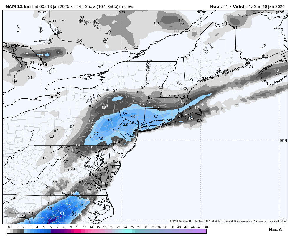
Here’s 00z Nam and the current radar, those 3”. Totals on PA verifying where the Nam had it..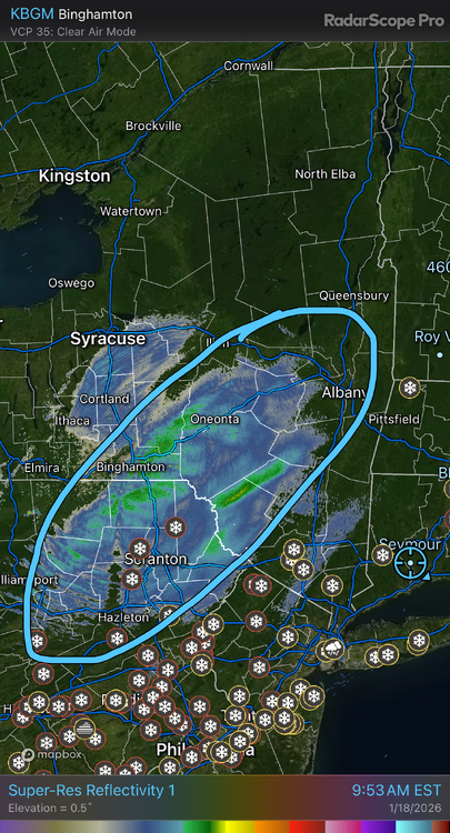

-

Rise of the Machines: January 18-19 Winter Storm Obs Thread
Hoth replied to WxWatcher007's topic in New England
Very nice departing band. Big fluffy dendrites. -

Storm potential January 17th-18th
RU848789 replied to WeatherGeek2025's topic in New York City Metro
As of 10 am the snow has lightened up considerably and we have 1.7" of new snow (1/2" the last hour); likely just on and off light snow for the next 3-4 hours. It's 32F. -
Maybe it’s 24hr snow total reports?
-
Lull 11 - evening
-

First Legit Storm Potential of the Season Upon Us
dryslot replied to 40/70 Benchmark's topic in New England
May not even have to take the tractor out again today, Looks like a bit of a messenger shuffle.