All Activity
- Past hour
-
It was pouring here in Woodstock in Cherokee County N of ATL just a few minutes ago with a passing shower.
-
Looks like more rain coming in from the West.
-
Dont even look severe hardly Wed,go figure with the models in the mid range..lol
-
Unless it fills in, radar has huge DC split to the SW. Hard to see a good line forming in time
-
-
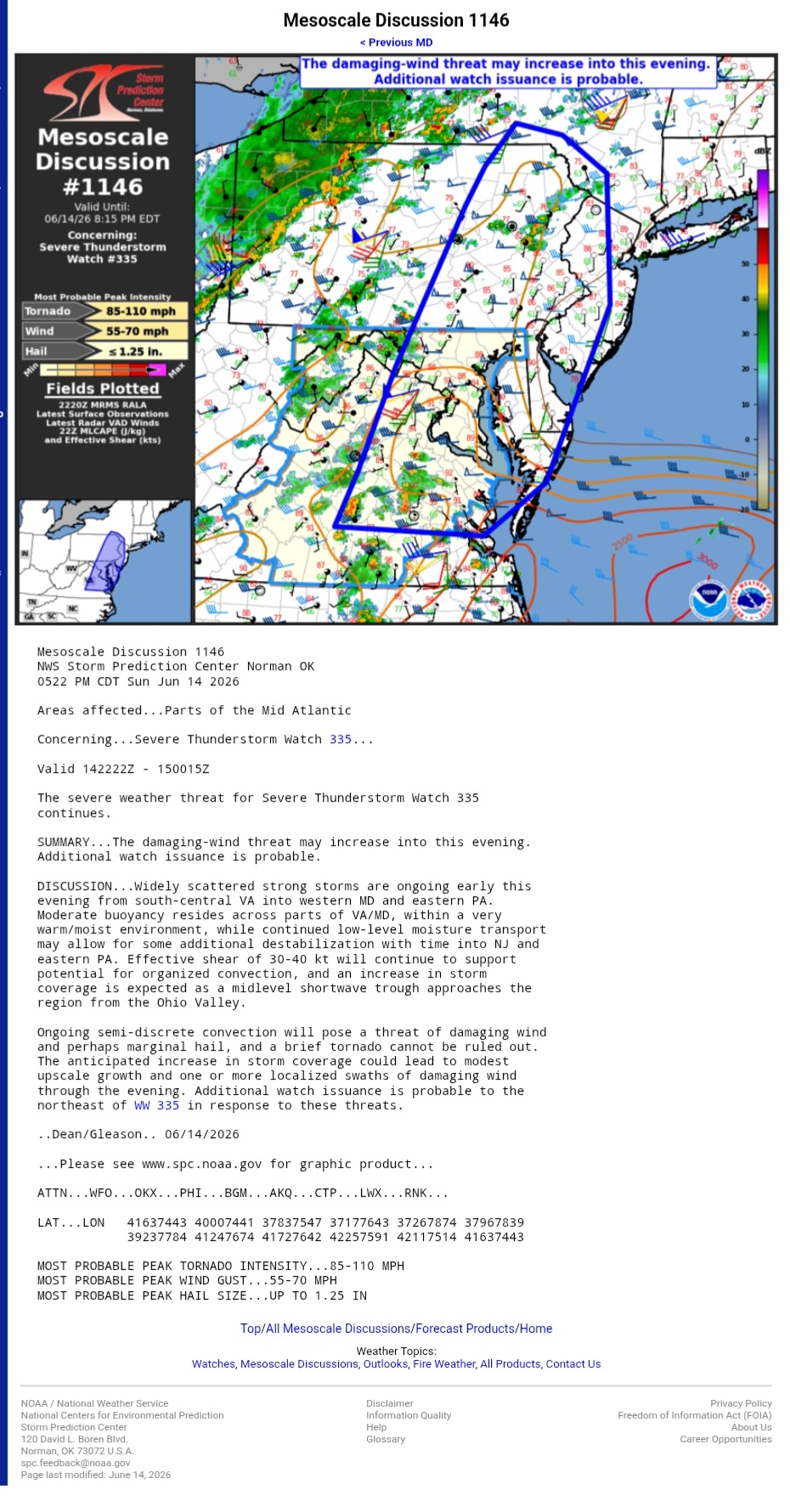
https://www.spc.noaa.gov/products/md/md1146.html Mesoscale Discussion 1146 NWS Storm Prediction Center Norman OK 0522 PM CDT Sun Jun 14 2026 Areas affected...Parts of the Mid Atlantic Concerning...Severe Thunderstorm Watch 335... Valid 142222Z - 150015Z The severe weather threat for Severe Thunderstorm Watch 335 continues. SUMMARY...The damaging-wind threat may increase into this evening. Additional watch issuance is probable. DISCUSSION...Widely scattered strong storms are ongoing early this evening from south-central VA into western MD and eastern PA. Moderate buoyancy resides across parts of VA/MD, within a very warm/moist environment, while continued low-level moisture transport may allow for some additional destabilization with time into NJ and eastern PA. Effective shear of 30-40 kt will continue to support potential for organized convection, and an increase in storm coverage is expected as a midlevel shortwave trough approaches the region from the Ohio Valley. Ongoing semi-discrete convection will pose a threat of damaging wind and perhaps marginal hail, and a brief tornado cannot be ruled out. The anticipated increase in storm coverage could lead to modest upscale growth and one or more localized swaths of damaging wind through the evening. Additional watch issuance is probable to the northeast of WW 335 in response to these threats.
-

2026-2027 Super El Nino
Stormchaserchuck1 replied to Stormchaserchuck1's topic in Weather Forecasting and Discussion
Ever since the Solar Max in May 2024, where a weakened magnetic field brought the aurora borealis very far towards the central part of the Earth - The warm season has been getting this cold 60-90N. At the end of last September, I think we had the lowest 500mb on record for the month in the N. Hemisphere, all time. -

2026-2027 Super El Nino
GaWx replied to Stormchaserchuck1's topic in Weather Forecasting and Discussion
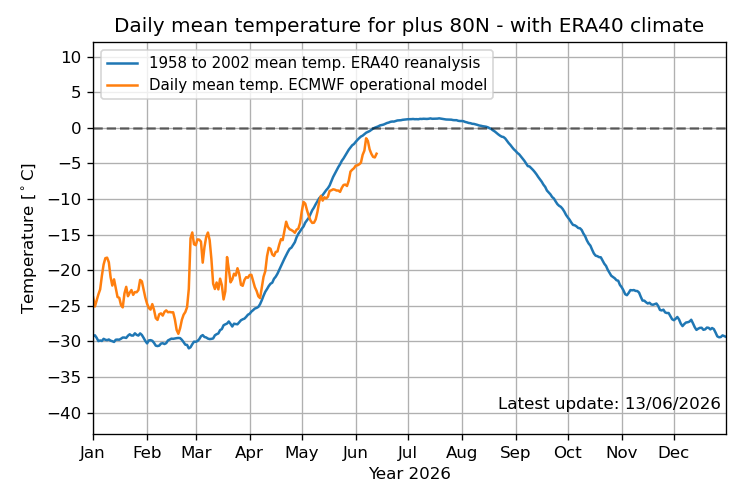
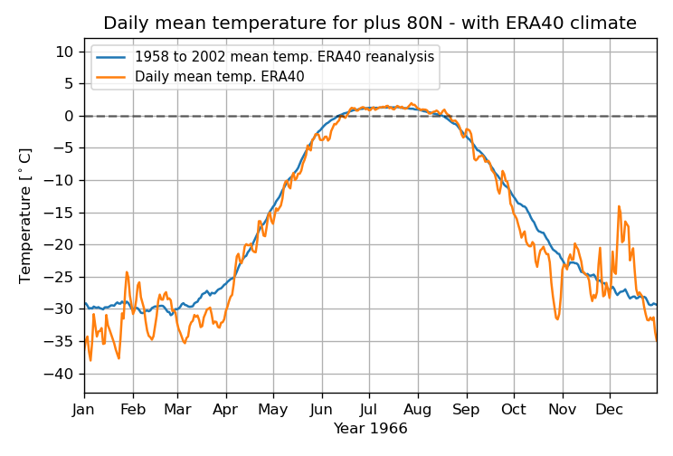
Chuck and others, check this out: June MTD is by a good margin the coldest on record N of 80N! Furthermore, June 9-13th has averaged ~-4C, which is ~2C colder than what had been the coldest on record, 2014! Records go back to 1958! This is pretty surreal in our warming world: 2026 coldest for June 1-13 ~-3.5C and June 9-13 ~-4C! 2014 2nd coldest for June 1-13 ~-2.5C and June 9-13 ~-2C 1966 3rd coldest for June 1-13 ~-2C 1980 3rd coldest for June 9-13 ~-1.3C
-

2026 Mid-Atlantic Severe Storm General Discussion
paxpatriot replied to Kmlwx's topic in Mid Atlantic
Second warned storm of the week here. This one was legit. Crazy gusts and small hail. Nice little show. -

2026 Mid-Atlantic Severe Storm General Discussion
SolidIcewx replied to Kmlwx's topic in Mid Atlantic
New MD Mesoscale Discussion 1146 NWS Storm Prediction Center Norman OK 0522 PM CDT Sun Jun 14 2026 Areas affected...Parts of the Mid Atlantic Concerning...Severe Thunderstorm Watch 335... Valid 142222Z - 150015Z The severe weather threat for Severe Thunderstorm Watch 335 continues. SUMMARY...The damaging-wind threat may increase into this evening. Additional watch issuance is probable. DISCUSSION...Widely scattered strong storms are ongoing early this evening from south-central VA into western MD and eastern PA. Moderate buoyancy resides across parts of VA/MD, within a very warm/moist environment, while continued low-level moisture transport may allow for some additional destabilization with time into NJ and eastern PA. Effective shear of 30-40 kt will continue to support potential for organized convection, and an increase in storm coverage is expected as a midlevel shortwave trough approaches the region from the Ohio Valley. Ongoing semi-discrete convection will pose a threat of damaging wind and perhaps marginal hail, and a brief tornado cannot be ruled out. The anticipated increase in storm coverage could lead to modest upscale growth and one or more localized swaths of damaging wind through the evening. Additional watch issuance is probable to the northeast of WW 335 in response to these threats. ..Dean/Gleason.. 06/14/2026 ...Please see www.spc.noaa.gov for graphic product... ATTN...WFO...OKX...PHI...BGM...AKQ...CTP...LWX...RNK... MOST PROBABLE PEAK TORNADO INTENSITY...85-110 MPH MOST PROBABLE PEAK WIND GUST...55-70 MPH MOST PROBABLE PEAK HAIL SIZE...UP TO 1.25 IN -
Cooled off to 85, dewpoint 75. Watching storms go up to the SW.
-
-
.thumb.jpg.6a4895b2a43f87359e4e7d04a6fa0d14.jpg)
Central PA Summer 2026 Discussion/Obs Thread
Yardstickgozinya replied to Voyager's topic in Upstate New York/Pennsylvania
Anyways, i've talked about this for several years and no one's ever really responded to it. But i've used LEMPs for years while i'm driving and working to know what's going on out there. Think of Cipher in the Matrix. Once you've listened long enough, you can make out the kind of stroke, whether or not it's getting closer and intensity. In the context of storms and meteorology, LEMPs stand for Lightning Electromagnetic Pulses. [1] They refer to the powerful, disruptive electromagnetic waves naturally radiated into the atmosphere during a lightning discharge. While they may not pose a physical shock risk to humans directly unless struck by lightning, they can induce dangerous power surges that damage or disrupt electronic devices and power grids. [1, 2, 4] Because lightning activity and cloud-to-ground strikes are a primary indicator of thunderstorm severity and structure, meteorologists utilize artificial intelligence and ground-based sensors to analyze LEMPs to understand a storm's behavior -
EZF storm went severe quick
-
Minimum of activity for the DC region so far
-
-
Orioles suck. That's abundantly clear. The manager is a loser. Why bring the Ravens into this? Harbaugh is finally gone. We have an all new and young coaching staff, plenty of talent, and the vibes have been great so far. I'm excited to see what this team can do. And snow? lol. How the fuck does that fit in here?
-
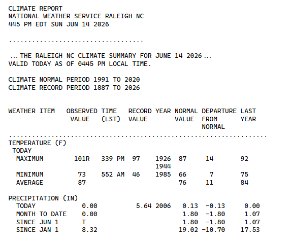
Storms sliding to my North by a few miles. If that one cell in northern chatham county holds together it may clip me or die out which is more likely. In other news, another new record at RDU today of 101*. Just baking here
-
Between 10 and 11 according to the hrrr
-
Central PA Summer 2026 Discussion/Obs Thread
Yardstickgozinya replied to Voyager's topic in Upstate New York/Pennsylvania
Indeed A cell out there somewhere right now putting out some insane LEMPs. Tune in to an unused, a m frequency and listen you have to choose an a m.Frequency, that puts you between a tower and a storm. You'll know when you get there, you'll hear it. -
Came out 15 minutes ago
-
Dang is Alby gonna be fired after a year? I mean he's very quickly losing the fanbase. I mean it's his first year, but ehhhh I don't know. So tired of Baltimore teams failing over and over again. What's gonna happen with the Ravens? They gonna disappoint us again too despite having a new coaching staff? Orioles, Ravens, snow...all disappointments.
-

2026-2027 Super El Nino
jaxjagman replied to Stormchaserchuck1's topic in Weather Forecasting and Discussion
+PDO can happen even in a NINA,but more likely in a NINO,maybe more study to what actually starts a period?Dacula has the Index of the PDO going back into the last century https://www.daculaweather.com/4_pdo_index.php -
Central PA Summer 2026 Discussion/Obs Thread
Yardstickgozinya replied to Voyager's topic in Upstate New York/Pennsylvania
I'm picking up abnormally, strong lightning strokes on my Am radio stations. The strokes generally don't cause this much interference at such long distance. -
We did not get anything. Look at the radar today! Looks like another shield as it moves east. Sigh