All Activity
- Past hour
-
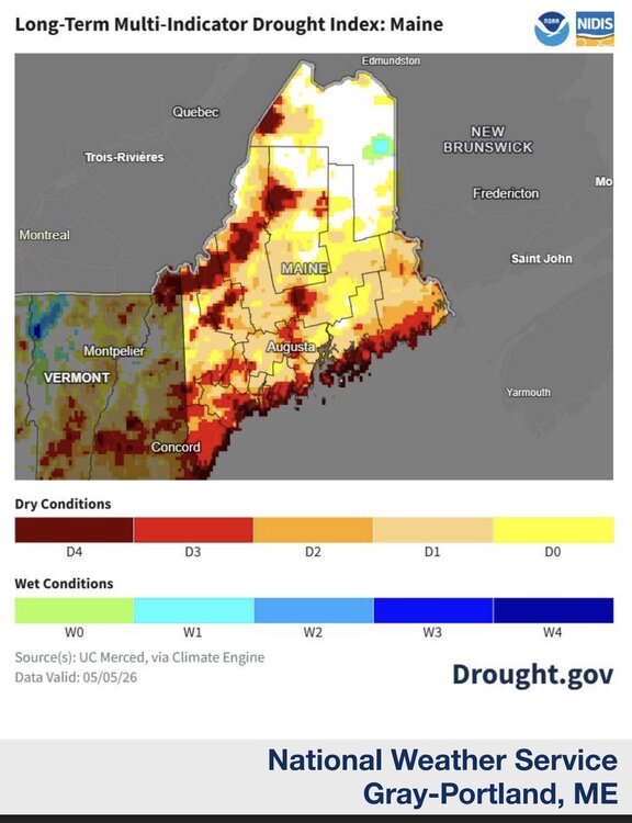
Nearly 2.5 inches overnight. Gyx issued its most recent drought update for Maine and NH, discouraging as usual. What caught my eye was this historical five year map of drought, and the coastal strip of high drought. To my experience in recent years, this lines up with what seems to be increasing phenomenon of a really strong marine layer due to stout south/southeast winds in summer shredding frontal thunderstorms that approach the coastm from the mountains. Is that possible, that we're seeing fewer coastal t-storms in summer due?
-
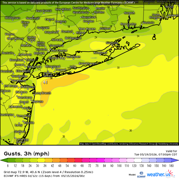
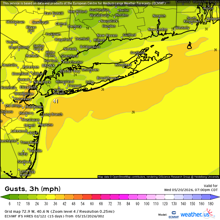
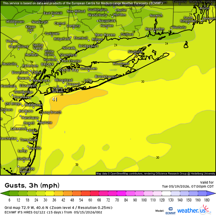
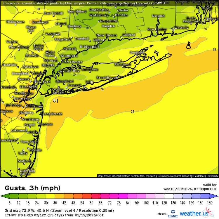
Yeah, I can remember days like this living in Long Beach. Current forecast is for 40mph or higher SSW gusts along the South Shore Tuesday and Wednesday. So plenty of dangerous rip currents expected. People should stay out of the water especially before the lifeguard season starts.
-

Central PA Spring 2026 Discussion/Obs Thread
Blizzard of 93 replied to Voyager's topic in Upstate New York/Pennsylvania
Beautiful day underway today before the heat builds for a bit. It should be a good evening to get the yard work done to avoid sweating over the weekend. -
2.40" First time >2" (by 7a-7p CoCoRAHS obs) in over 2 years.
-
Kind of happy about that-I'll take 85 vs 97
-
34.3 this morning. Crazy for May 15th. Not unheard of, but still crazy.
-

Spring 2026 Pattern Discussion Thread
Carvers Gap replied to Carvers Gap's topic in Tennessee Valley
Looks like frost on the rooftops this morning, even in parts of Kingsport. We only missed the all-time record low by two degrees at the airport. -
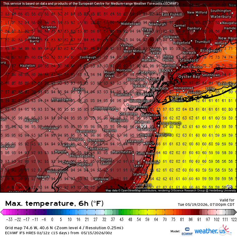
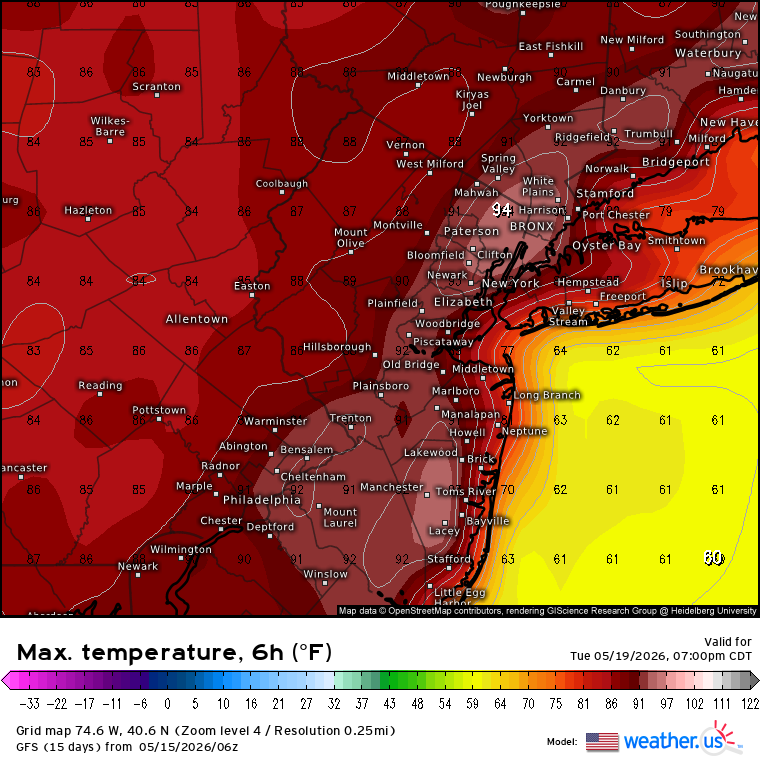
This upcoming heat looks very meh east of the city. Maybe mid 80s or so on the N Shore? The south shore might struggle past 70 if we have strong S wind every day.
-
Spring 2026 Pattern Discussion Thread
Carvers Gap replied to Carvers Gap's topic in Tennessee Valley
TRI's records/normals' listed date for May 3rd reads 9999 for the record low. But it should also be a record low. That makes two record lows for the month. 90s on tap for Sunday! Whiplash weather! IMHO this is just a continuation of the winter pattern which had HUGE swings. I think we head into a more stable, warm pattern from this point forward. I think. -
Looks like a nice stretch.
-

Central PA Spring 2026 Discussion/Obs Thread
Voyager replied to Voyager's topic in Upstate New York/Pennsylvania
Kind of breezy and cold here this morning. It's 47 currently, but the wind has a bite to it. -
Spring 2026 Pattern Discussion Thread
Carvers Gap replied to Carvers Gap's topic in Tennessee Valley
That should break the record low at TRI by three degrees. The old record was 35. That is the fourth latest freeze in TRI history. -

2026 Spring/Summer Mountain Thread
Maggie Valley Steve replied to Buckethead's topic in Southeastern States
37 at the house this morning. -
Spring 2026 Pattern Discussion Thread
Carvers Gap replied to Carvers Gap's topic in Tennessee Valley
-

2026 Spring/Summer Mountain Thread
nchighcountrywx replied to Buckethead's topic in Southeastern States
As low as 27.1 overnight on Mitchell -
Spring 2026 Pattern Discussion Thread
Carvers Gap replied to Carvers Gap's topic in Tennessee Valley
It looks like the airport has dipped to 32F. That is a big time bust from my point and click which was 40-41! I went out and covered my stuff last night thankfully. The GFS and NAM have been kicking butt and taking names w/ low temps. That should be the last time we hit freezing until next fall - famous last words though! -
37° this morning at the house with patches of frost around! I knew when it was already 45 by 11 last night that it was probably going to be in the 30’s this morning. The wind died completely down and the dry airmass did the rest. This is just 2 days shy of the latest frost I’ve ever seen, and that was years ago. Really impressed with the cold this month, it’s been something else!
- 234 replies
-
- 1
-

-
- severe
- mountain snow
- (and 1 more)
-
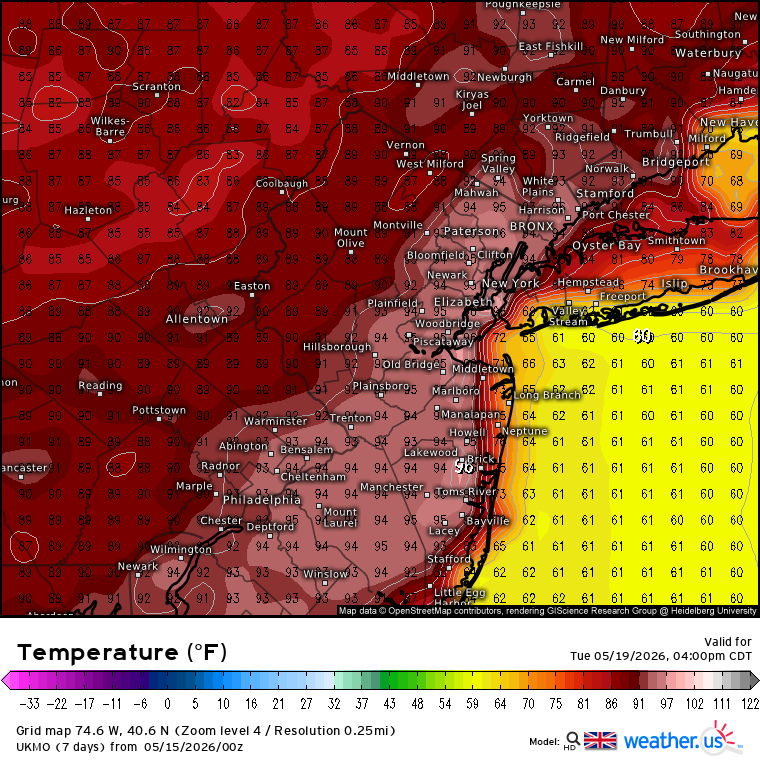
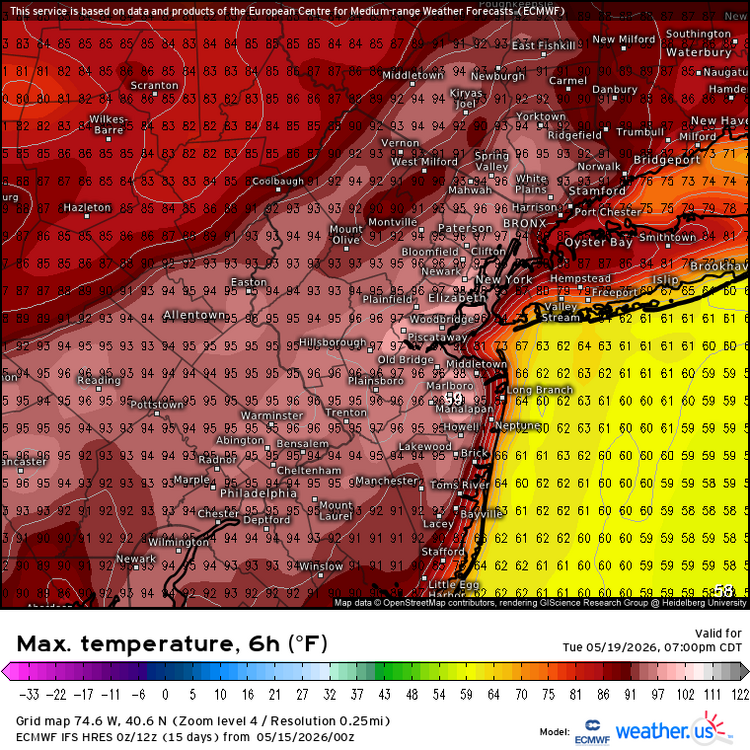
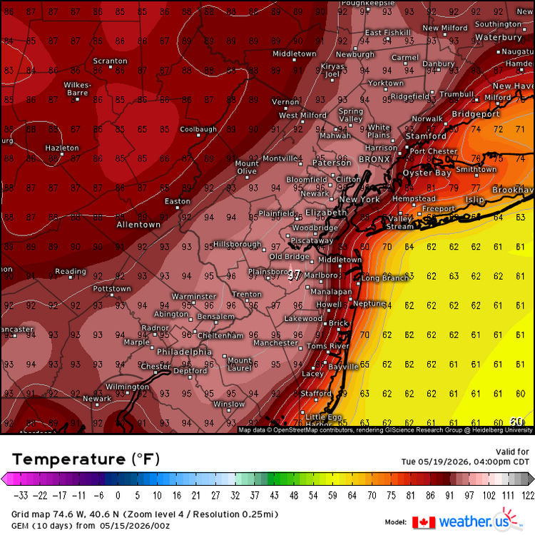
The model mean is currently 94-99° for the usual NJ warm spots. So the drought both in the source region and locally should enhance. Since this is one of the worst droughts across the CONUS for the month of May. The record NJ high for the month of May is 99°. So some monthly maxes could be in jeopardy. Still around 5 days out so we can still refine. NJ made it to 98° in May back in 2022. In any event, we haven’t seen this type of May heat before leading into such a strong El Niño. May 2015 only made it to 91° in Newark. Time Series Summary for NEWARK LIBERTY INTL AP, NJ - Month of May Highest Maximum Temperature Click column heading to sort ascending, click again to sort descending. 1 1996 99 0 2 2022 98 0 - 1992 98 0 - 1987 98 0 - 1962 98 0 3 1965 97 0 - 1895 97 0 4 2021 96 0 - 2016 96 0 - 1969 96 0 - 1964 96 0 - 1914 96 0 - 1880 96 0 5 2010 95 0 - 1994 95 0 - 1986 95 0 - 1941 95 0 - 1939 95 0 The strongest developing El Niño May maxes 2023 90 0 2015 91 0 1997 86 1982 85 1972 82


-
A cold frost morning this morning with a low of 31 degrees. Considerably lower than what was forecast.
-

2026-2027 Strong/Super El Nino
snowman19 replied to Stormchaserchuck1's topic in Weather Forecasting and Discussion
If these record-breaking traditional ONI projections of over +3C are correct and the RONI continues its trend of lagging the ONI by 0.5, 1982-83, which was the strongest super El Niño on the RONI (+2.5C) since 1950, would be the closest RONI analog. Again, assuming these ONI forecasts for over +3C are correct, we would easily tie, if not beat 82-83 on the RONI - Today
-
looks like after Tuesday and Wednesday that’s it for the good warmth for a little while. Maybe comes back after Memorial Day, but core of The heat over the Great Lakes means intrusions of cooler possible in New England. Although could still average above normal.
-
Couple breaks in the overcast after the steining
-

Central PA Spring 2026 Discussion/Obs Thread
pawatch replied to Voyager's topic in Upstate New York/Pennsylvania
42 degrees this morning. .02” from pop up drizzle yesterday. -
1.66". Decent drink Sent from my SM-S921U using Tapatalk
-
Looks like Wednesday, maybe Thursday for a chance of some severe? Nothing huge of course... just the risk for it