All Activity
- Past hour
-
 Official first measurable earlier as a heavy squall moved through dropping temps and visibility under 1/4 mile briefly left .2 on the board which had all since melted, 36/25 now.
 -
Yeah I remember most guidance had November finishing with normal to slightly above normal temps.
-
It gets confusing as they use UTC but basically overnight tonight is a solid chance and then we will see if a daytime hit by the next one can hold on until dark tomorrow night.
-
Do you have food at your breweries? Always happy to drink more if I can get a burger or something with it.
-
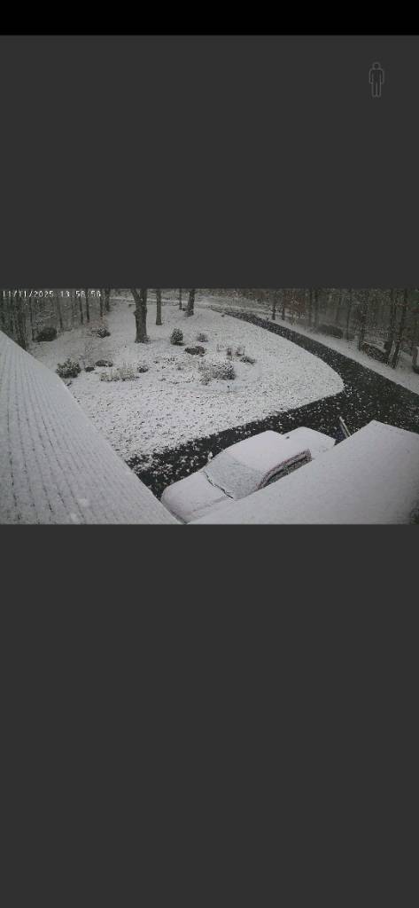
 First flakes and first accum of the season down here as well hiding the oak leaves for now..
_compress91.thumb.jpg.04562dc65aebefc7aa0e0de53fb286c0.jpg)
-
 Still flurries and the wind is nuts. Basketball hoop blew over. Gotta be a 50 mph gust there
 -
Looks like my snow will survive the day in the shady/north facing areas. It's only made it to 40 today and this is about peak sun here this time of year. It will be behind the mountains to my west by 3pm.
-
 We were on 2A near the King Phillip. Looks like the town put down treatment. Maybe it was icy?
 -
 Great snow squall in West Point and Garrison, NY. Most surfaces briefly snow covered. Might have been half an inch in a few grassy spots before quickly melting.
 -

2025-2026 ENSO
40/70 Benchmark replied to 40/70 Benchmark's topic in Weather Forecasting and Discussion
Thanks. I don't give regional specifics for your area, but you can deduce my thoughts based on the composites and such. In case you couldn't, "get nude" about somes it up- -

November 2025 general discussions and probable topic derailings ...
tavwtby replied to Typhoon Tip's topic in New England
catching the tail of that at my place, it was ripping on and off pretty much since about 10, I'm back at work next to BDL so nothing here. -
12-26-10 to 1-27-11 is the record around NYC Metro for 33 day snowfall at 61.5”. Boston was able to surpass that feat from 1-24-15 through 2-25-15 with 96.3”. Baltimore came close from 1-25-10 to 2-26-10 with 55.0”. So very impressive for the I-95 corridor to experience such amazing snowfall production in a little over a month from 2010-2015 at multiple locations during different seasons. Maximum 33-Day Total Snowfall for NEWARK LIBERTY INTL AP, NJ Click column heading to sort ascending, click again to sort descending. 1 61.5 2010-12-26 through 2011-01-27 0 2 53.6 2010-12-25 through 2011-01-26 0 3 48.7 1978-01-13 through 1978-02-14 0 4 45.7 1978-01-17 through 1978-02-18 0 5 45.5 1961-01-15 through 1961-02-16 0 6 45.2 1978-01-12 through 1978-02-13 0 7 45.0 1978-01-14 through 1978-02-15 0 8 44.9 1978-01-16 through 1978-02-17 0 - 44.9 1978-01-15 through 1978-02-16 0 10 44.8 1961-01-14 through 1961-02-15 0 Maximum 33-Day Total Snowfall for Boston Area, MA (ThreadEx) Click column heading to sort ascending, click again to sort descending. 1 96.3 2015-01-24 through 2015-02-25 0 2 94.4 2015-01-23 through 2015-02-24 0 - 94.4 2015-01-22 through 2015-02-23 0 - 94.4 2015-01-21 through 2015-02-22 0 Maximum 33-Day Total Snowfall for Baltimore Area, MD (ThreadEx) Click column heading to sort ascending, click again to sort descending. 1 55.0 2010-01-30 through 2010-03-03 0 - 55.0 2010-01-29 through 2010-03-02 0 - 55.0 2010-01-28 through 2010-03-01 0 - 55.0 2010-01-27 through 2010-02-28 0 - 55.0 2010-01-26 through 2010-02-27 0 - 55.0 2010-01-25 through 2010-02-26 0
-

November 2025 general discussions and probable topic derailings ...
ineedsnow replied to Typhoon Tip's topic in New England
getting some house shakers here and howling out.. last week meh compared to today yet no advisory or anything -
 Sag Harbor webcam looking pretty sweet. Off and on flurries here all day so far, including now.
 -
 Legit stuff in the Berks
 -
BOS: 55-65” NYC: 25-35” PHI: 12-20” DC: 8-15”
-
I'd imagine it's simply random chance of where the heaviest bands set up coming off the lakes. Some areas had much higher rates than others. @SnowenOutTherewas hiking some ridges in WV yesterday and reported he saw 1-2in in one spot and 3-4in 10 miles away at another
-

Historic Tennessee Valley Cold, Snow, and Ice Events
John1122 replied to Carvers Gap's topic in Tennessee Valley
I was out on a muzzleloader hunt when it started that afternoon. I didn't even know it was supposed to snow that I can recall. (no internet back then). I can distinctly remember my grandpa stating it was his first white Halloween that evening when around 3 inches had fallen. In 1995 we got dusting in mid-October. The top of the mountains around here got more, I recall driving on top of Cross Mountain that night in moderate snow with around 1/2 inch on the ground. It was either October 18th or 19th. -

November 2025 general discussions and probable topic derailings ...
WinterWolf replied to Typhoon Tip's topic in New England
Wow…that’s the real deal…very nice . First accumulation. -
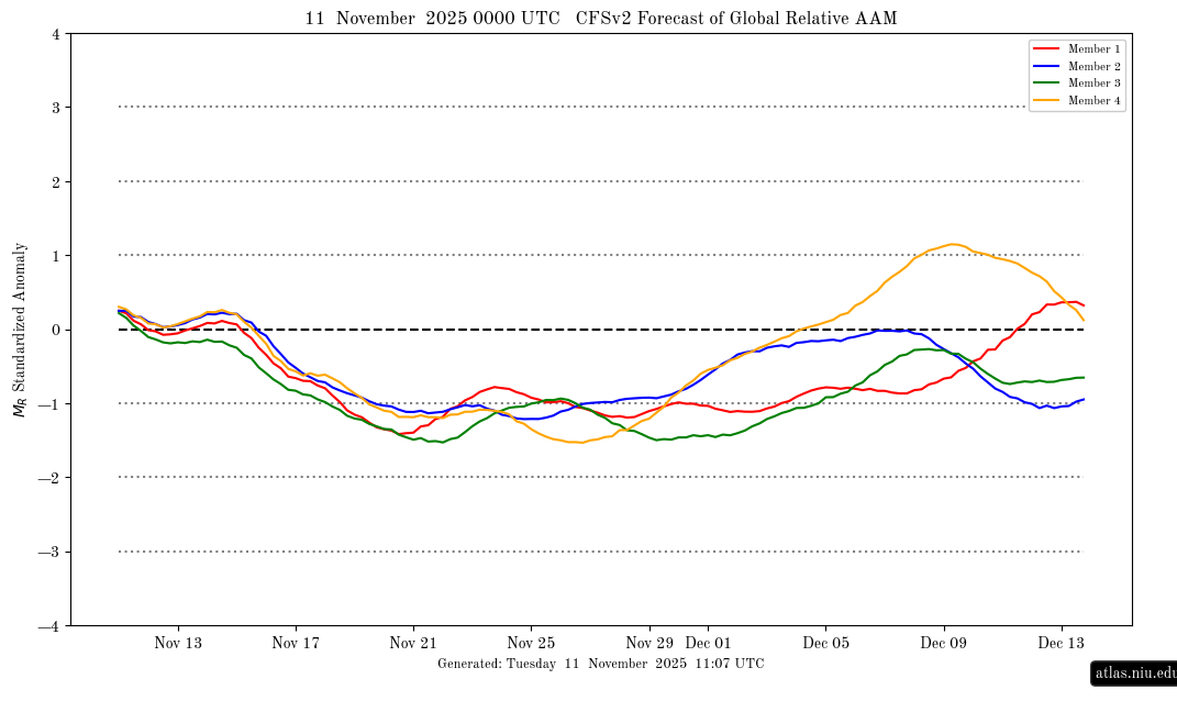
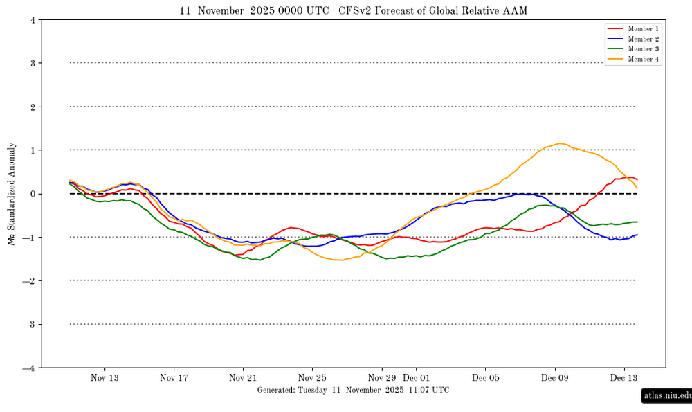
AAM is still looking to go back to a solid negative next week and last for 2 weeks. However, afterward, this is showing a move back up closer to neutral for early Dec fwiw:
-
Same here but don't snooze on tonight either.
-
Had a gust to 46 that knocked out the internet. Word from Comcast is “network damage” and it may be back in a few hours.
-
 Nice streamer overhead-35 and moderate snow-brief accum on colder surfaces!
 -

November 2025 general discussions and probable topic derailings ...
Lava Rock replied to Typhoon Tip's topic in New England
Nice burst. 30.6f. Sent from my SM-S921U using Tapatalk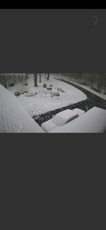
-
Much closer view here but still the same


_compress91.jpg.2221fcb96cdc96c624bfa4cee7d86e66.jpg)