All Activity
- Past hour
-

Central PA Winter 25/26 Discussion and Obs
pasnownut replied to MAG5035's topic in Upstate New York/Pennsylvania
CMC also slower and trend looks to be slowing this down a bit -

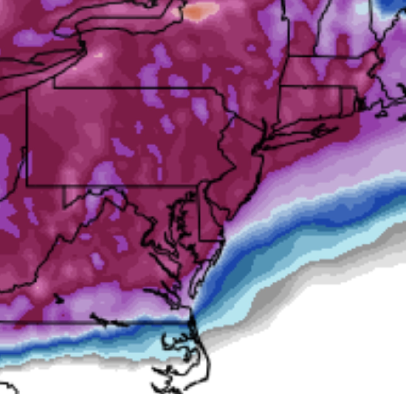
January 2026 regional war/obs/disco thread
dryslot replied to Baroclinic Zone's topic in New England
Slow it even more, Another 24hrs, Give it some room. -
Doesn't stop until Monday morning or Noon.
-
Let's see what ensembles show, I feel like they will not be as suppressed and we will be in a good spot.
-

January 2026 regional war/obs/disco thread
ORH_wxman replied to Baroclinic Zone's topic in New England
Congrats on Coke streamers mixed in with the synoptic precip -
This is reminding more of the 93-94 storm @John1122. Lots of ice and snow in Knoxville followed by cold temps. I40-74 was down to like one lane for a few days due to that. What do you think?
-

January 24-25: Miracle or Mirage
SomeguyfromTakomaPark replied to stormtracker's topic in Mid Atlantic
yeah we get fantastic overrunning and a tad bit of coastal....if we can get that to capture/tuck that's the big dog scenario. -

Possible Record Breaking Cold + Snow 1/25 - 1/26
IrishRob17 replied to TriPol's topic in New York City Metro
Some things don't change. -

January 25/26 Jimbo Back Surgery Storm
Brick Tamland replied to Jimbo!'s topic in Southeastern States
-

January 2026 regional war/obs/disco thread
Sey-Mour Snow replied to Baroclinic Zone's topic in New England
CMC is a significant you can even say huge snowstorm up into NE Mass.. -
Very icon-esque.
-

Possible Record Breaking Cold + Snow 1/25 - 1/26
SnowGoose69 replied to TriPol's topic in New York City Metro
CMC was just slower overall but also moved towards the more east later transfer idea. I said last night that either happens way west in the TN Valley or in coastal SC/GA in these setups. It won't typically happen over WRN GA/AL. -

January 25/26 Jimbo Back Surgery Storm
Maggie Valley Steve replied to Jimbo!'s topic in Southeastern States
Still garbage here as well. -

January 25/26 Jimbo Back Surgery Storm
NYweatherguy replied to Jimbo!'s topic in Southeastern States
Looks like it's game on for metro Atlanta. -

Possible Record Breaking Cold + Snow 1/25 - 1/26
eduggs replied to TriPol's topic in New York City Metro
I gotta admit, the GFS/AIGFS make me nervous. That ULL in the Southwest has to eject. AND it needs to be well timed with northern stream shortwaves dropping south through MT and the Dakotas. There are always failure modes. -
Comparing the GFS to all other models for this upcoming storm might be the worst gap I've ever seen. We really need to retire it and invest more into our modeling here ... Oof. Unless it wins a coup and is correct but doubt it.
-
I don't like waiting on a second system west of the Apps. Too many times I have seen that slide into the Carolinas during previous storms. Need a 0z Euro solution or AIFS look. Fortunately, the GFS is well...the 12z GFS. There is a reason it scores poorly. The 12z GEM is trending south. And as always...read Jeff's post above.
-

January 2026 regional war/obs/disco thread
CoastalWx replied to Baroclinic Zone's topic in New England
Days and days? -

Possible Record Breaking Cold + Snow 1/25 - 1/26
WeatherGeek2025 replied to TriPol's topic in New York City Metro

-
No, did not move up to this area until 2016. I have often wondered what the NJ coldest minimum temperature on record really is. I believe it is recorded as -34 in River Vale (Bergen County) back in 1904. Have to believe it would have been colder than that in the Sussex County valley locations. Also how accurate is the -34 reading? Who and exactly where was it recorded? Lived in Park Ridge, next to River Vale for 10 years from mid 70's to mid 80's. Saw some cold readings during that time but temperatures on the coldest morning were always notably colder out in NW NJ.
-
Central PA Winter 25/26 Discussion and Obs
pasnownut replied to MAG5035's topic in Upstate New York/Pennsylvania
CMC takes the look of the Euro. We'd sign....well I would. -
-
150 pops a new coastal just off shore
-

Pittsburgh/Western PA WINTER ‘25/‘26
Mailman replied to Burghblizz's topic in Upstate New York/Pennsylvania
Just a foot area-wide on the Canadian. -

January 25-26 Winter Storm Potential
Violentweatherfan replied to Ralph Wiggum's topic in Philadelphia Region
I think the GFS is what it is because of how it’s handling the cold air. Therefore suppressed, how often do these super cold temps verify. Rarely, so I think the GFS will come north