All Activity
- Past hour
-
I imagine this winter might be further down the list if it ranked the two best consecutive months, rather than all three. This is ranking very high for end to end cold and snow, but I have the perception that there have been many "deeper" winters in modern times. I guess one example is 2014-2015 when the warm December of 2014 kept a great winter from making that list (although it did have a noteworthy March). Since 3 months is a long time to keep a consistent weather pattern in NYC, I suspect there would be a different distribution of slightly shorter, but more intense winter rankings.
-
I know that Jan. 13, 2024 was at/near astronomical peak tides, but I was still surprised that it didn't make the list, as it set a new high water record that day, by 0.3 ft breaking the record set three days earlier. (Unless later calculations have changed those peaks)
-
Yup it was a good winter but after yesterday and today’s beautiful weather, I’m ready for the warm up! Already have grass showing in south facing areas on the lawn so should only be a couple more days now - so much better than what we dealt with from the January sleet storm
-
Still FULL snow cover…by a lot. 41F Havent seen grass since the first storm
-

E PA/NJ/DE Winter 2025-26 Obs/Discussion
Voyager replied to LVblizzard's topic in Philadelphia Region
Man, I've had enough. And why is it that every time the PV splits, it heads right for the northeast? Why can't it go west once in awhile? -
Clouds dissolving as they move east baby.
-
Yeah I didn't expect it. Feels so good!
-
It's human nature. Every little hill on LI has appeared in some story, newspaper article, or ad as being the high point on LI over the years. Superlatives sell and they seem to be easier for people to talk about.
-
February Precipitation stats at my location: Melted: 1.96". Y.T.D. Melted: 4.72". February snowfall: 15". Snowfall Season to date: 49.8". AVERAGE snow depth this morning with 90-95% coverage: 3.5". South facing lawns and slopes bare ground to 1.5". Shaded / north facing locations: 4-5". Was driving around southern Union and Morris Counties yesterday (Chatham, Summit and New Providence) and snow melt pretty dramatic there. They had 15-20" in spots and there is quite a bit of bare ground. Eyeballing looked like 3-4" in areas with most remaining depth. By this coming Monday, 1 week after the storm 15-20" of snow will have been wiped out.
-
42 beautiful degrees already.
-
February Precipitation stats at my location: Melted: 1.96". Y.T.D. Melted: 4.72". February snowfall: 15". Snowfall Season to date: 49.8". AVERAGE snow depth this morning with 90-95% coverage: 3.5". South facing lawns and slopes bare ground to 1.5". Shaded / north facing locations: 4-5". Was driving around southern Union and Morris Counties yesterday (Chatham, Summit and New Providence) and snow melt pretty dramatic there. They had 15-20" in spots and there is quite a bit of bare ground. Eyeballing looked like 3-4" in areas with most remaining depth. By this coming Monday, 1 week after the storm 15-20" of snow will have been wiped out.
-
Yep, great response there. As I mentioned before, people have no idea how hard it snowed there. Literally hours of the atmosphere choking on snow.
-
Euro had the right idea.
-
Records: Highs: EWR: 68 (1976) NYC: 677 (1976) LGA: 66 (1976) JFK: 66 (1976) Lows: EWR: 1 (1934) NYC: 5 (1934) LGA: 10 (2014) JFK: 11 (2014) Historical: 1792: Heavy snow caused the Ashley River Bridge in Charleston, SC to collapse. (Ref. Wilson Wx. History) 1846: William S. Forrest, in "Historical and Descriptive Sketches of Norfolk and Vicinity" in 1853, recorded the Great Gust of 1846. The Great Gust was a severe coastal storm that produced 5 feet waves in Norfolk. 1900 - A massive storm spread record snows from Kansas to New York State. Snowfall totals rangeD up to 17.5 inches at Springfield IL and 43 inches at Rochester NY, with up to 60 inches in the Adirondack Mountains of New York State. (David Ludlum) 1900: A massive storm produced record snow from Kansas to northwest Ohio and southern Michigan from February 27 to March 01. The observation at the University of Kansas in Lawrence reported 15 inches of snow on the 27th was "phenomenal; only one heavier snowfall has been recorded for any month, a depth of 16 inches on February 11th and 12th, 1894." (CD). The Coop near Wamego, KS, in the northeast part of Kansas, a record-breaking 24 inches fell in just 12 hours! Other snowfall amounts in Kansas include 19.0" in Abilene, 18.7" in Topeka, 18.0" in McPherson, and 18.0" in Ellinwood. Topeka saw 17.3" on February 27, the most recorded in 24 hours. In Missouri, heavy snow fell over a considerable portion of the state on the 27th and 28th. From Bates, Cass, Jackson, and Platte counties in the west, to St. Charles, Lincoln, Pike, Ralls, Marion, Lewis, and Clark counties to the east, snowfall ranged from 10 to over 20 inches. The snow drifted severely in many places, and where the fall of snow exceeded 10 inches, railroads were blocked, and county roads rendered impassable for several days. A Coop in Darksville, in northern Randolph County, reported drifts from 6 to 8 feet deep in many places. Houstonia Pettis County's drifts were the worst for more than 30 years. Snowfall amounts in Missouri include 22" in Miami, 20" in Richmond, 13.9" in Columbia, and 13" in Kansas City and Jefferson City.The storm probably gave central and northern parts of Illinois some of the highest snowfall totals since 1830-1831. (CD) The Coop in Astoria measured an astonishing 37.8 inches with this storm! Coatsburg saw 26 inches. Other snowfall amounts include 21" near Normal, 17.5" in Springfield, and 13" near Jacksonville.Heavy snow, freezing rain, and sleet occurred in Indiana from February 28 to March 01. In South Bend, 16" of snow fell, prompting street-car employees to work all night to keep the tracks open. As a result, railroad traffic was delayed on all lines. Fairmount and Greensburg reported ice and sleet covered the ground on the 28th. Marion, in Grant County, observed the heaviest sleet storm in many years. Some snowfall amounts include 21" at Valparaiso Waterworks, 18" in Syracuse, Angola, and Fort Wayne, and 16" in South Bend and Huntington. Northwestern Ohio and southern Michigan saw heavy snowfall from February 27 to March 01. The Coop in Wauseon Water Plant recorded 20.5" of snow. Toledo received 20.2 inches. Grape, Michigan, west-northwest of Monroe, said the heavy snow made all roads impassable. Mail could not be delivered from Grape to Monroe due to badly drifted snow. Some snowfall amounts from southern Michigan include 18" in Hillsdale, Grape, and Somerset, 14" in Detroit, 13" in Lancing, and 12" in Kalamazoo. 1952 - An intense storm brought coastal sections of southeastern Massachusetts to a halt, stranding 3000 motorists on Lower Cape, and leaving ten thousand homes on the Cape without electricity. Winds gusting to 72 mph created mountainous snowdrifts of the 18 inches of snow which buried Nantucket and Hyannis. A barometric pressure reading of 29.02 inches was reported at the center of the storm. (The Weather Channel) 1952: A powerful Nor'easter hit Cape Cod with winds of 70-80 mph and snowfall amounts of 12-20 inches. These conditions created 12 feet drifts. 1962: Wilmington, North Carolina, reached a high temperature of 85 degrees. This is the warmest temperature on record during February. 1987 - A powerful storm produced severe thunderstorms in Louisiana and Mississippi early in the day. About mid morning a monstrous tornado touched down near Moselle MS and grew to a width of two miles as it passed near Laurel MS. The tornado traveled a distance of 40 miles killing six persons, injuring 350 others, and causing 28.5 million dollars damage. The tornado swept homes right off their foundations, and tossed eighteen wheel trucks about like toys. Strong straight line winds associated with the powerful storm system gusted to 70 mph at Jonesboro AR and Carbondale IL. (The National Weather Summary) (Storm Data) 1988 - Thunderstorms in California produced severe weather during the early morning hours. Strong thunderstorm winds, gusting to 74 mph, downed trees in the Sacramento area. Unseasonably mild weather prevailed in the northwestern U.S. The afternoon high of 71 degrees at Portland OR was a February record. (The National Weather Summary) (Storm Data) 1989 - Thunderstorms in the southeast corner of the nation produced winds gusts to 58 mph at Fort Lauderdale FL, and a total of seven inches of rain. Heavy snow whitened parts of the Northern Plateau and the Northern Rockies, with ten inches reported at Marion MT. (The National Weather Summary) (Storm Data) 1990 - Showers and thunderstorms over the Southern Plains Region capped a record wet February for parts of Oklahoma. Totals for the month ranged up to 9.11 inches at McCurtain, with 4.63 inches reported at Oklahoma City. Snow and sleet fell across northern Oklahoma, with four inches reported at Freedom and Jefferson. Snow also spread across southern Kansas into Missouri and Arkansas, with six inches of snow reported at Harrison AR. In Alaska, February temperatures at Nome averaged 21 degrees below normal, ranging from -38 degrees to 29 degrees during the month. (The National Weather Summary) (Storm Data) 2003: The total snowfall from 1435 of the 27 to 0115 of the 28th was 5.2 inches. Making this the snowiest February in the last 23-years at the Annandale-Barcroft Hills Weather Center with a total of 30.9 inches. The old record was 23.2 in 1982-83 and was our wettest February in the last 23-years with a total of 8.19 inches of precipitation. The old record was 7.26 inches in 1998. It was also our 3rd snowiest winter in the last 23-years and the snowiest since 1995-96 when the total winter snowfall of 61.2 inches was record. (Ref. Annandale Weather Records) 2004: A snowstorm affected much of central and western Virginia...with 6 to 12 inches of snow reported in the Blue Ridge Mountains of southwest Virginia. The heaviest amounts, in the 10 to 12 inch range, fell in Roanoke city/county, and in Franklin county.Ref. Virginia Department of Emergency Management E-News 2005: A late season snowstorm brought 7.7 inches of snow to NYCs central park and 9.5 inches to Newark airport. 2010: Late February Nor' Easter- Back-to-back Nor' Easters on February 23-28 dumped 20 inches or more of snow from New York City into New England, with over 40 inches at some locations. This was the third major Northeast snow storm of the year, and the fourth this winter. Snowfall in New York City's Central Park reached 20.9 inches, and the city's February total of 36.9 inches set an all-time monthly record. Snowfall totals exceeded 30 inches north of New York City with this storm, including 38 inches near Monticello, New York. Hunter Mountain in the Catskills unofficially accumulated four feet of snow from February 25-28. Outstanding snow totals during February 23-27 included 43 inches in Randolph, New Hampshire; 52 inches in Woodford, Vermont; and 53 inches in Potter Hollow, New York. (Ref. Weatherwise U.S. Weather Highlights of 2010 page 3 and 4) 2012 - The first confirmed February tornado in Nebraska state history struck Lincoln and Logan Counties shortly after 4PM. The EF-0 tornado was on the ground intermittently for up to six minutes and traveled 3 miles before dissipating in southwest Logan County. The path of the tornado was over open rangeland and cropland where limited damage occurred. Patches of snow were still on the ground at the time. (NWS North Platte)
-
Here are a couple recent


-

Major Hurricane Melissa - 892mb - 185mph Jamaica landfall
ncforecaster89 replied to GaWx's topic in Tropical Headquarters
https://x.com/tbrite89/status/2027736823888216388 -
-
More food for thought. If that area that was under those extremely heavy returns of 30-40dbz got say 16-24". Then what about all those reports in CT of 16-24" and in Middlesex and Worcester counties up to ORH? Thats basically saying all those reports are too high as well because those areas were well outside the main heavy banding and for far less time, even when they were. Looking back at that radar animation several times, there is no question to me that a large area of 24-40" fell especially when i go back and compare it to something like 2005 or 2015.
-
It's definitely a little wacky looking - I'm not sure other than doing completely separate color-coded maps how they could have implemented this differently. I like the idea/principle, though!
-
The 2nd half of the coming week has some minor potential. GFS has some modest supercell composite parameters - and even the Euro has some instability around. Interesting enough for early March, at least. Nothing substantial, of course. CSU-MLP has some minor probs painted over some of our area Friday.
-
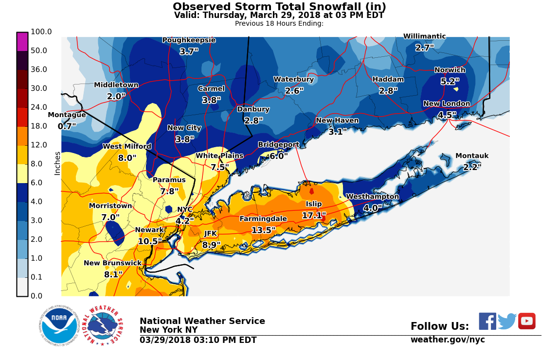
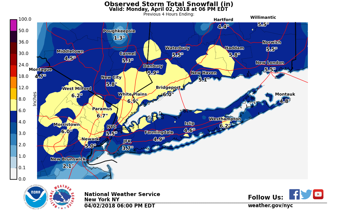
Yup or a frigid airmass like April 2018 (6 inches CPK). I just feel that it would really put this winter into epic category for CPK. IMBY at approx. 52 which is the most since 56 inches in 17/18. Would rate as an A- IMBY if this was the last of the snowfall.
-
Seems on track . Snowy morning into afternoon
-
37 ./ 36 low clouds / fog burning off and snow continuing to evaporate. Outside of some mixing or wet snow Sunday and Tuesday afternoon/evening it looks like wetter vs whiter week and near avg - lots of clouds. Warmer 3/7 - beyond.
-
I’m curious to see where we go from here. Last winter didn’t suck and this year was really good. Not saying every winter for the next decade or so will rock, but maybe we’re finally digging out of this crap pattern we’ve been in since 2016. A weenie can dream.
-
All old. Tossed.