All Activity
- Past hour
-
 Weather channel going for the southern ice apocalypse and 12-18 for nyc
 -

“Cory’s in LA! Let’s MECS!” Jan. 24-26 Disco
RUNNAWAYICEBERG replied to TheSnowman's topic in New England
Scooter on monday, ”I can’t believe it, 2 feet on the nose”… -
It looks like it has gotten more intense this run; if that image verifies, lord have mercy...
-
TEMPLETON, Mass. — The town of Templeton, Massachusetts, is currently experiencing a shortage of road salt ahead of this weekend's winter storm. StormTeam 5 predicts the potential for most of the state to get between one and two feet of snow. "Templeton has several loads ordered but will not receive anymore deliveries until mid of next week," police said in a social media post. Authorities are urging residents to use extreme caution when traveling this weekend, as the town's ability to fully treat the roadways remains limited. Templeton DPW crews will continue to monitor conditions and prioritize main roads, emergency routes, and public safety areas, according to police. For now, the DPW said it will plan to pretreat the roads with brine if conditions allow for it. "We appreciate residents' patience and cooperation as we work through this temporary supply issue," police said.
-
That’s not for this upcoming system that is a past winter storm.
-
 .
. -
This is true. I personally cut them in half based on what I've experienced. I think they get the "zone" right, but the amounts are overdone.
-

Richmond Metro/Hampton Roads Area Discussion
benjammin replied to RIC Airport's topic in Mid Atlantic
Several people have said that the Euro does not handle freezing rain accumulations well. Hopefully that's the case. Sent from my Pixel 10 Pro XL using Tapatalk -

Pittsburgh/Western PA WINTER ‘25/‘26
southpark replied to Burghblizz's topic in Upstate New York/Pennsylvania
Their messaging/discussion has gotten so much better over the last so many years. -
Davis Nolan
-
Can I get a comparison of the the 12ZA OPF to this please?
-
(002).thumb.png.6e3d9d46bca5fe41aab7a74871dd8af8.png)
January 25-26 Winter Storm Potential
ChescoWx replied to Ralph Wiggum's topic in Philadelphia Region
Folks will need to measure and wipe their snowboards as the sleet begins (plus run out and shovel). Sleet counts as snow albeit at about 3:1 a bit slower accumulations! -
Apple weather in DC finally dropped from 20-24" to 14-17". Still much too high, but they're getting there.
-
Verbatim? Likely bad (ie. Mixy). But it's more just an observation in general. The OpEuro mirrors it's companion AIFS fairly closely. The GFS... uh... not so much. That may mean something.
-
OMG..not in the dreaded gray. We've arrived people. Honestly, weenie blinders off, this would be what I would go with rn.
-

“Cory’s in LA! Let’s MECS!” Jan. 24-26 Disco
Damage In Tolland replied to TheSnowman's topic in New England
When we start seeing 30+ amounts in spots. -

Possible Record Breaking Cold + Snow Sunday 1/25 - Tuesday 1/27
eduggs replied to TriPol's topic in New York City Metro
Most of us are still right on the edge IMO. I disagree with the sentiment that today has seen positive trends. I'm encouraged by the stability of the AI models, but the UK, CMC/RGEM, ECM, and NAM have persistent mid-level lows that are right at the cusp of eating into snow totals with sleet. That really hasn't changed much since last night. I expect that future NAM runs will lead the way in terms of signalling how far advanced the warm nose gets. This could still be 4" or 18" at NYC. -
Euro doesn’t look for off at the end of the run, maybe a late development, but it’s close .
-

January 25/26 Jimbo Back Surgery Storm
Brick Tamland replied to Jimbo!'s topic in Southeastern States
How often so these extreme ice scenarios that the models are showing actually happen? I thought more often than not they end up being way overdone. -
“Cory’s in LA! Let’s MECS!” Jan. 24-26 Disco
Damage In Tolland replied to TheSnowman's topic in New England
Won’t be much wind thankfully. No one wants that with powder -

Central PA Winter 25/26 Discussion and Obs
Superstorm replied to MAG5035's topic in Upstate New York/Pennsylvania
Is Thundersnow possible with this system? Asking for a friend, lol. . -
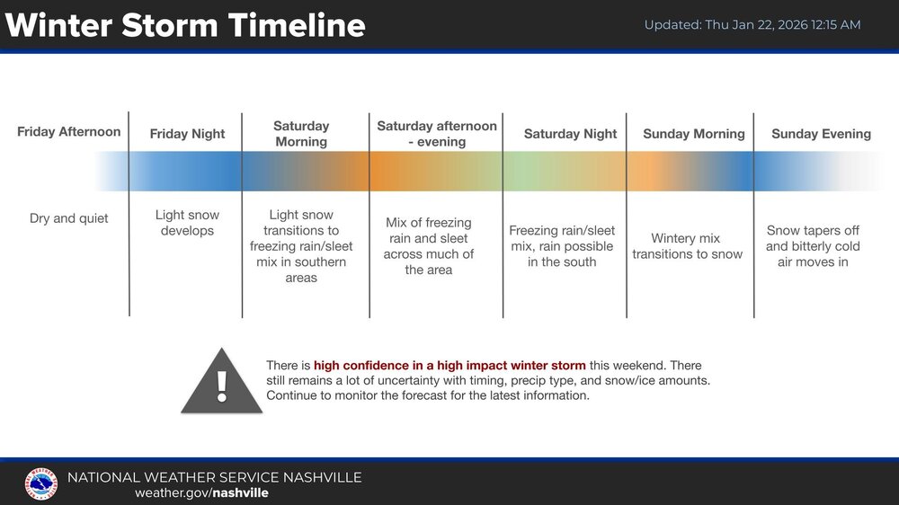
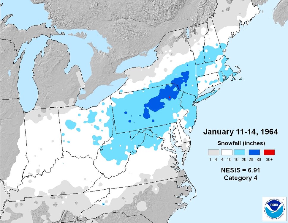
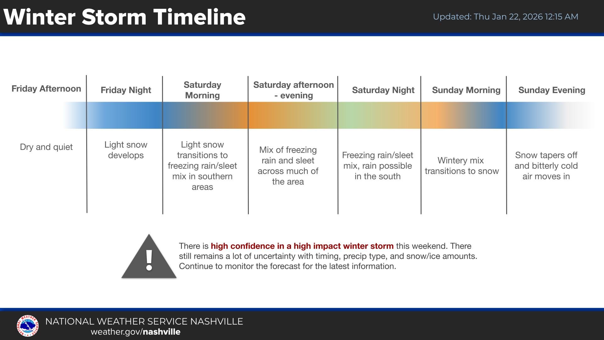
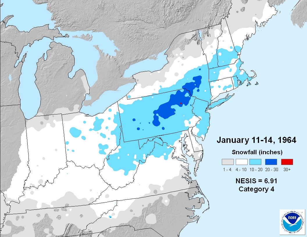
If the GFS is right, we will easily see this storm rank way up there on the NESIS scale. Below is Jan 1964 which is 8th on the list. And this storm could have an even more widespread 10"+ swath. Just something fun to think about. What really makes or breaks how high up these storms get on the NESIS list is how much snow DC, Philly, NYC, and Boston proper get. Because the NESIS equation specifically takes into account population AND how much snow said populations get
.thumb.png.1f45073816a27bebf9f7ff48c5a8b1c9.png)
-
The slow increase in QPF is a good sign right now too. In a lot of our higher end storms, they went from lower end “major” (like 8-14/10-15 type) on guidance into that 12-18/15-20 zone as we got inside 3 days. I agree with @Typhoon Tip that there’s sneaky potential on Monday with the lower level onshore flow being forced into the arctic dome…it’s one of those things that looks like mood snow or an additional 1-3” on guidance but then reality is 20 to 1 hooked aggregates that someone grabs an additional 7-8” on 0.37 of QPF….your snow growth zone is basically from the sfc to 700mb during that time so the lift being mostly low level doesn’t hurt as much as usual. Im still pretty ambiguous on how that will play out though. If we don’t keep the flow onshore, then it won’t be much but if we do, then things get more interesting.
-
If they euro is right yes… .
-

Richmond Metro/Hampton Roads Area Discussion
overcautionisbad replied to RIC Airport's topic in Mid Atlantic
RIP. Central Va is done for


.png.d61b49bef2b172758a2d37eb89054d36.png)


