All Activity
- Past hour
-

September 2025 OBS-Discussion centered NYC subforum
bluewave replied to wdrag's topic in New York City Metro
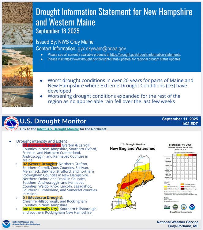
Record heat to our west yesterday with temperatures only missing 90° by 1°. This is why I have been discussing the potential for 85°-90° heat even when models weren’t showing it. Record recent dry pattern in the source region for the heat. 443 CDUS41 KCTP 190624 CLIIPT CLIMATE REPORT NATIONAL WEATHER SERVICE STATE COLLEGE PA 224 AM EDT FRI SEP 19 2025 ................................... ...THE WILLIAMSPORT PA CLIMATE SUMMARY FOR SEPTEMBER 18 2025... CLIMATE NORMAL PERIOD 1991 TO 2020 CLIMATE RECORD PERIOD 1895 TO 2025 WEATHER ITEM OBSERVED TIME RECORD YEAR NORMAL DEPARTURE LAST VALUE (LST) VALUE VALUE FROM YEAR NORMAL ................................................................... TEMPERATURE (F) YESTERDAY MAXIMUM 89R 351 PM 88 1964 75 14 78 -
I mentioned it a few days ago but the WPAC SST alignment matches previous years that saw a lot of +WPO. This -PDO cycle has been different than the last major -PDO cycle we saw (1940’s-1970’s), where where we now have the western North Pacific boiling, unlike back then
-

2025 Atlantic Hurricane Season
WolfStock1 replied to BarryStantonGBP's topic in Tropical Headquarters
Why does it matter? People don't build homes etc. "due to" a hurricane. Many of these places - including Crenshaw - survived Harvey just fine, and many of these places have been built since Harvey and are thus counted towards the stats in that article. The Houston area didn't get completely destroyed and have to be rebuilt from nothing after Harvey. The point is - most homes and businesses are being built much better to withstand flooding these days, thus it's not as foolish as it's made out to be. IMO the key is - people need to know that there are risks, be wiling to accept them (including insurance), and IMO the government should not subsidize the risk like it often does. -
That sucks but a good reason you're moving I hope.
- Today
-
Hmmm
.thumb.png.b5ddcbf6d8ee9c4c4491c0e152f232ef.png)
-

September 2025 OBS-Discussion centered NYC subforum
SACRUS replied to wdrag's topic in New York City Metro
Highs: TEB: 87 EWR: 87 New Brnswck: 85 LGA: 85 PHL: 84 TTN: 84 ISP: 83 BLM: 83 NYC: 83 ACY: 80 JFK: 79 -
FOLKS https://xl.weatherstar.dev/
-
GLOBAL MODEL DATA TIME 0000UTC 19.09.2025 TROPICAL STORM GABRIELLE ANALYSED POSITION : 21.2N 53.0W ATCF IDENTIFIER : AL072025 LEAD CENTRAL MAXIMUM WIND VERIFYING TIME TIME POSITION PRESSURE (MB) SPEED (KNOTS) -------------- ---- -------- ------------- ------------- 0000UTC 19.09.2025 0 21.2N 53.0W 1007 31 1200UTC 19.09.2025 12 22.0N 55.0W 1008 32 0000UTC 20.09.2025 24 23.6N 57.0W 1009 32 1200UTC 20.09.2025 36 24.7N 58.8W 1009 32 0000UTC 21.09.2025 48 26.5N 60.2W 1010 34 1200UTC 21.09.2025 60 28.2N 60.8W 1009 41 0000UTC 22.09.2025 72 30.2N 61.7W 1006 46 1200UTC 22.09.2025 84 33.0N 61.7W 1002 44 0000UTC 23.09.2025 96 35.8N 59.1W 996 45 1200UTC 23.09.2025 108 38.1N 54.2W 985 51 0000UTC 24.09.2025 120 39.9N 47.4W 977 61 1200UTC 24.09.2025 132 41.4N 39.6W 971 67 0000UTC 25.09.2025 144 42.7N 32.6W 974 53 1200UTC 25.09.2025 156 44.9N 26.7W 978 46 0000UTC 26.09.2025 168 48.3N 21.8W 980 41
-
It's kind of silly to see the H5 change the SSTAs and then everyone go with what the SSTs show. For the next 10 days, we have a Gulf of Alaska low and Aleutian ridge.. the PDO is going to go pretty negative again. but these are the symptom, not the cause. It would actually be easier to roll forward PNA patterns/analogs instead of always looking at SSTs, because SSTs are actually always a few weeks behind. MJO/ENSO waves move the N. Pacific pattern, which in turn move around the SSTAs. Kelvin/Rossby waves are probably as close as your cause/main drivers. There have been a few more rossby waves with developing La Nina, which will probably create more -PNA tendency going through the Fall (maintaining a -2 to -3 PDO). Watch the ENSO subsurface, if cold water -200m strengthens, it's more -PNA/-PDO tendency, and warmer water there is more +PNA/+PDO. The gravity waves at the surface move these subsurface water anomalies.
-

September 2025 OBS-Discussion centered NYC subforum
jm1220 replied to wdrag's topic in New York City Metro
We have 10 more years I think until we can say this with confidence. We had a bonanza period that lasted about 18 years with a few duds thrown in. We were due for a sharp reversion to the mean-there's no way NYC can get away with regular 40" snow winters. So if this new regime started in 2018, that would be 2036 when we have an equally long timeframe as the snowier one. Also the background warming means marginal snow situations 30 years ago would be rain now-so the bad years are even worse. -
 Your current implied forecasts for rest of season are shown in previous post -- where it is assumed Gabrielle will become a non-major hurricane at some future point. We are past the halfway point of climatology for seasonal totals, although a few seasons can be found where this was before the halfway point (not many). Some of us are going to need a finish like 1887 to get anywhere near our forecasts. I would have to say the two forecasts scored in the table (Hotair, retrobuc) are looking like the favorites at this point.
 -
1.13" for the event total here. Side note: The evening twenty-two years ago today was a gorgeous 10/10.
-

2025-2026 ENSO
michsnowfreak replied to 40/70 Benchmark's topic in Weather Forecasting and Discussion
Exactly. I enjoy that we have people from all different areas posting. And i would expect that everyone is most concerned about their own area. But have to be careful to apply localized logic in a broadbrush sense. As I've said many times, theres no question that snow lovers in the Great Lakes would prefer a la nina any day over el nino. Of course ENSO itself is only one piece of the puzzle, but theres enough history to see what is the better enso state for the winter enthusiast in MI. Of course it will still snow here multiple times in an El Nino...but it will be a much quieter winter than a Nina. The full winter as a whole seems to hold more importance for the midwest, Lakes, and new England in terms of how we view it, whereas the coastal areas into the mid Atlantic are all about what pattern can give them a monster storm. -
Franklin Co W of the CT River is where you really start to feel disconnected from E MA. I mean, the Quabbin Hilltowns are pretty rural and isolated too but Greenfield and W is where you realize, you are not commuting distance to Boston and are not close to any populated areas. I lived in Cambridge for many years, so I still miss the restaurants and entertainment, just not the crowds and traffic.
-

2025 Atlantic Hurricane Season
dbullsfan replied to BarryStantonGBP's topic in Tropical Headquarters
I'm ecstatic nothing is happening, but this is weird right? Seems way too quiet. -
32,33 34 came up but so long ago I just leave it alone.
-

E PA/NJ/DE Autumn 2025 Obs/Discussion
Kevin Reilly replied to PhiEaglesfan712's topic in Philadelphia Region
Total rain down here in Media the other day was 0.48" not too bad actually. -
I'm moving up to Saugerties this weekend, rip to my legendary radiating hole
-

2025-2026 ENSO
so_whats_happening replied to 40/70 Benchmark's topic in Weather Forecasting and Discussion
I feel like there was a way but maybe that was a different forum I was on. So true though 100+ pages... im not going through that. CDAS almost looks representative to RONI output compared to OISST and CRW. -
Because it's hot? I like it out there, more of a laid back valley lifestyle. Even where you and I are now is kind of connected to the Boston hustle vibe. RT 2 East is packed in the AM.
-
The supposed current heat has not been a factor here. My high today was 80.4, the first day above 80. It was 54 this morning. Chilled the house with the windows open. Haven't had my AC on in almost 30 days now. Basically a late summer miracle.
-
I liked that area when I worked out there, rather live where I am now.
-
I’m planning to save on heating costs this winter by having no clouds.
-
While we're at it why don't you quantify similar. I'm willing to bet you don't mean less.
-
Got to love this paragraph. If I'm reading it correctly eversource, if temperatures are similar to the warmest 10-year period on the face of the Earth I'm good? "Last winter’s bills were higher in part because the weather was much colder than usual. If this winter’s weather and energy use go back to what's typical over the past 10 years, even with higher rates, we estimate your total bill to be similar to last year."


.png.529631e5c629538d7e1a010b26121432.png)


.thumb.png.4150b06c63a21f61052e47a612bf1818.png)


