All Activity
- Past hour
-

First Winter Storm to kickoff 2025-26 Winter season
ineedsnow replied to Baroclinic Zone's topic in New England
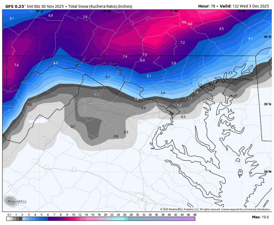
Rates could be wild for a bit if things break right.. 6z GEFS mean bumped up to 7 for here -
Initial point and click of 6-8”, looks reasonable at upper bound. If we can just figure out NAM being out to lunch a decent starter storm will be at hand.
-
Heads up for early risers in the metros - looks like maybe a chance of some frozen / mixed precip until 8 am or so…
-
That’s a rather nice run.
-
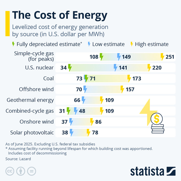
Don't agree with your comments. The article provided references. Other than fully depreciated gas and nuclear, Renewables are the lowest cost of electricity in the US. New gas plants will be much more expensive than fully depreciated; and, as the article states, costs and backlogs for new gas plants are increasing.
-
-
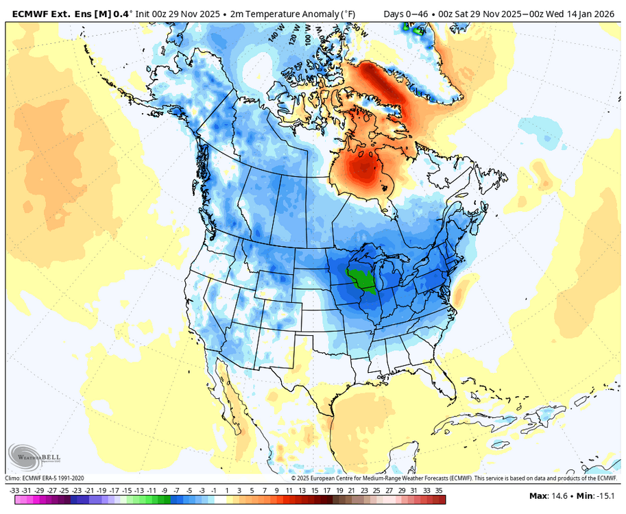
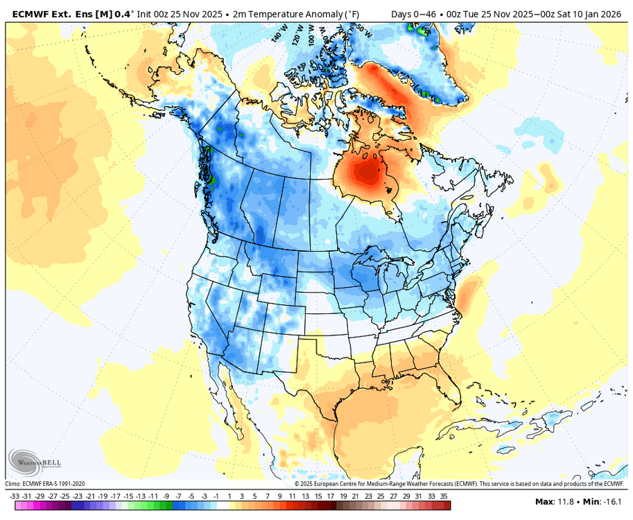
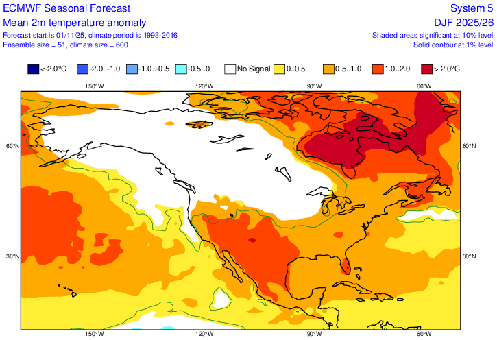
Euro Weeklies 46 day 2m temp anomalies: 11/25 run: NYC and Chicago -3F 11/30 run: NYC -6F, Chicago -8F (would be coldest in many years for that period) Euro seasonal winter fcast issued Nov 1st: huge warm bust potential increasing, which could end up like last winter:
-

First Winter Storm to kickoff 2025-26 Winter season
Torch Tiger replied to Baroclinic Zone's topic in New England
-

First Winter Storm to kickoff 2025-26 Winter season
H2Otown_WX replied to Baroclinic Zone's topic in New England
C'mon, that's a ridiculous forecast lol. The forward speed of this won't allow for accumulations that high imo. -
What delightful thoughts these are to be pondering as I sip on some coffee early this morning. Yeah, let's get the MJO to shove that warm pool out to the dateline...
-

Central PA Fall Discussions and Obs
Voyager replied to ChescoWx's topic in Upstate New York/Pennsylvania
-

Central PA Fall Discussions and Obs
Voyager replied to ChescoWx's topic in Upstate New York/Pennsylvania
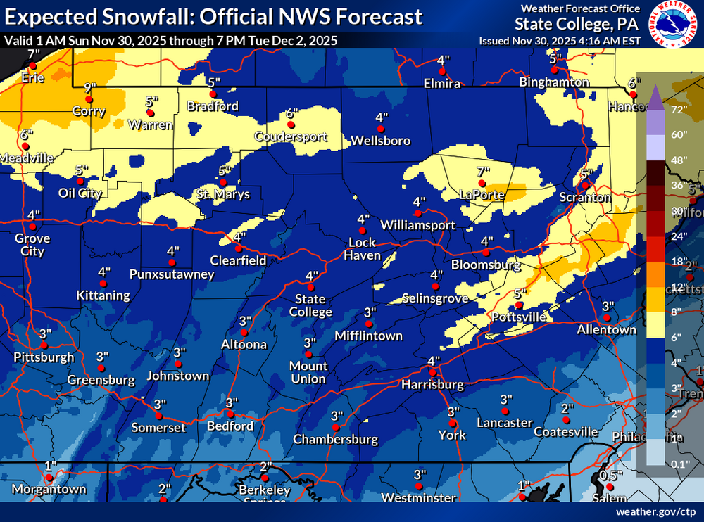
So did CTP. Last night they said 3-5 for my backyard on Tuesday, and now they added in overnight accumulations that take it to 4-10. Monday Night A chance of snow after 1am. Mostly cloudy, with a low around 23. Calm wind. Chance of precipitation is 50%. New snow accumulation of 1 to 3 inches possible. Tuesday Snow. The snow could be heavy at times. High near 37. Calm wind becoming northwest around 5 mph in the afternoon. Chance of precipitation is 90%. New snow accumulation of 3 to 7 inches possible. -

First Winter Storm to kickoff 2025-26 Winter season
ORH_wxman replied to Baroclinic Zone's topic in New England
GFS came in a little colder too. Maybe we’ll get a GFS/Euro convergence today. -
- Today
-
Nov 28-30th Post Turkey Day Winter Storm
migratingwx replied to Chicago Storm's topic in Lakes/Ohio Valley
-
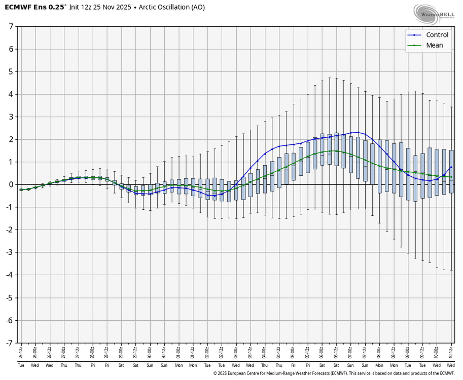
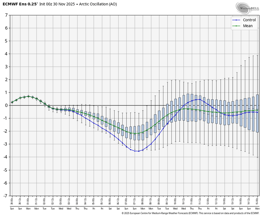
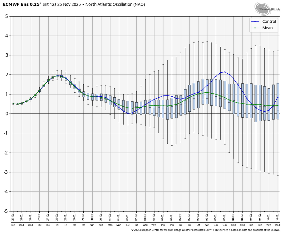
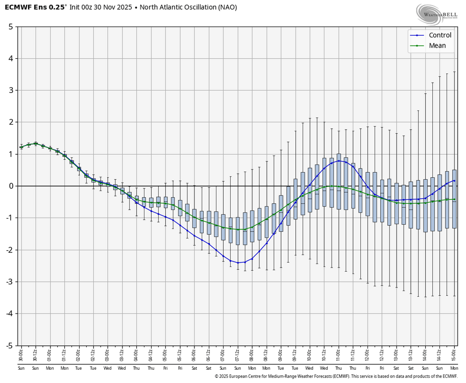
Although only barely, it’s now confirmed that we on 11/28/2025 just had the earliest major SSW (reversal) since 11/27/1968 with the zonal wind a whopping 30 m/s BN despite it only barely reversing: Kudos to the Euro Weeklies mean of 100 members predicting the weakest point of the SPV to the day a month before it occurred: This reminds me of the models being initially oblivious to the upcoming -NAO/-AO that appeared after the 2/16/2023 major SSW: EPS 11/25 12Z run: all +NAO EPS 11/30 0Z run: almost all -NAO including as early as Dec 4th, when 11/25 run had +NAO Similar comparisons for AO: EPS 11/25 12Z run: EPS 11/30 0Z run: like night and day
-
Light sleet and 35 degrees on morning dog walk
-

First Winter Storm to kickoff 2025-26 Winter season
ineedsnow replied to Baroclinic Zone's topic in New England
Tuesday Snow, mainly after 9am. The snow could be heavy at times. High near 32. Calm wind becoming east around 6 mph in the morning. Chance of precipitation is 90%. New snow accumulation of 6 to 10 inches possible. Tuesday Night Snow likely, mainly before 2am. Mostly cloudy, with a low around 18. Northwest wind 6 to 9 mph. Chance of precipitation is 70%. New snow accumulation of 2 to 4 inches possible -
oscar5764 changed their profile photo
-
Central PA Fall Discussions and Obs
MAG5035 replied to ChescoWx's topic in Upstate New York/Pennsylvania
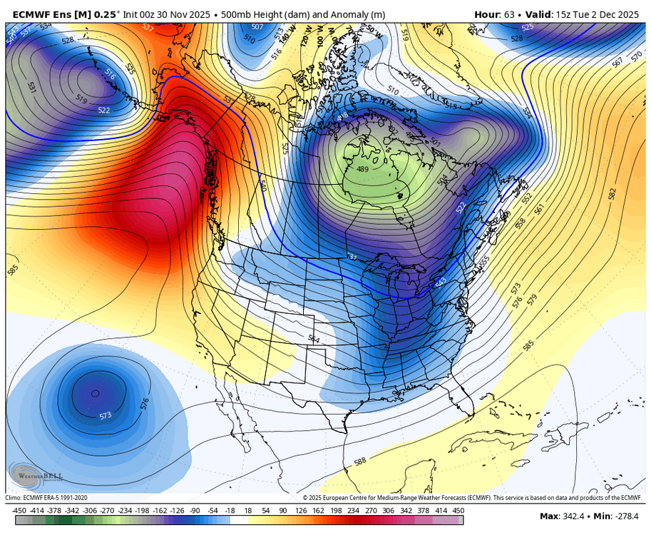
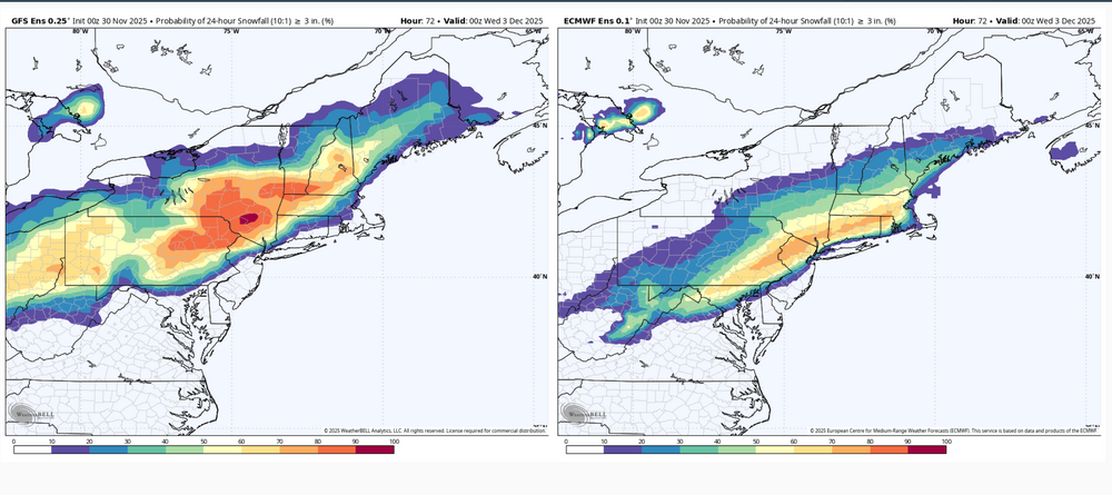
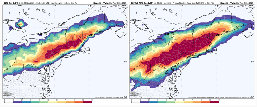
Overviewing all the model/ensemble stuff the last few runs I would think most if not all the subforum is looking good for the first widespread synoptic snowfall of the early winter season. I’m not really concerned about any P-type issues except for the LSV near the MD line, and even there I think there’s a good chance of advisory type snowfall or even a mostly snow event presuming we don’t trend the surface low NW much in the next 36 hrs. Think the ceiling in our area is likely to be 5-6” but mostly a 3-5” type event. Main issues I see to sort out at the moment is axis and width of the swath of heaviest snowfall. The regular Euro suite has been a bit more disjointed upstream developing the shield of precip. It seems to be the most progressive of the major stuff to include the GFS and Canadian suites, as well as the AI Euro. This makes for a late blossom of the precip shield over the majority of C-PA and a more focused swath as the coastal low deepens and moves NE. Basically everyone still sees snow but it’s a lot more 1-2” or so with a tighter swath of 3-5” type amounts… which is the furthest SE with that getting a couple inches all the way into DC. It’s reflective in the associated ensembles too. Might as well show them all. 0z GEFS vs Euro EPS 24hr probs of 3”+ 0z Canadian ensemble vs Euro AI ensemble for 24hr 3”+ probs, actually a pretty good match on swath axis The other end of the spectrum is the 3 and 12km NAM being the furthest NW, most wound up solution (no surprise) still as of 6z this morning. I’m sure thats the type of solution the MU guy is envisioning as the end game of what this system does in terms of the boundary being north. Which is certainly possible but I don’t see the amp in the pattern to bend this up in a Chesapeake Bay to NYC to Southern New England trajectory as deep as it has the low developing. And honestly that’s about the only kind of track I would entertain detrimental p-type issues reaching far up into southern PA and the Sus Valley. Otherwise I think this pattern setup we’re in is plenty cold enough to overcome early season climo. Yea the ridge axis is just off the Pacific Coast, but the PV is also anchored over Hudson Bay. Look at the 500mb anomalies for storm time. The only detriment of a +NAO in this setup would be a progessive pattern. -

Winter 2025-26 Medium/Long Range Discussion
HillsdaleMIWeather replied to michsnowfreak's topic in Lakes/Ohio Valley
Euro also has the system for next weekend now, if the storm today, the duster Monday night and this new storm come to pass we could all have one hell of a snowpack -

Nov 28-30th Post Turkey Day Winter Storm
HillsdaleMIWeather replied to Chicago Storm's topic in Lakes/Ohio Valley
Final total here is 9 inches. Very memorable storm, thankfully with less blowing and drifting than our last big November storm -

First Winter Storm to kickoff 2025-26 Winter season
dendrite replied to Baroclinic Zone's topic in New England
NAM is still very amped. Nice model battle. Back to bed.

