All Activity
- Past hour
-
12Z UKMET: 1005 mb Galveston hour 33 -Has TS force winds C and W LA coast but nowhere in TX. -Rainfall for GLV-HOU only ~0.5-75”. Max is ~4” and is near Matagorda Bay. TROPICAL STORM BERTHA ANALYSED POSITION : 29.8N 88.4W ATCF IDENTIFIER : AL022026 LEAD CENTRAL MAXIMUM WIND VERIFYING TIME TIME POSITION PRESSURE (MB) SPEED (KNOTS) -------------- ---- -------- ------------- ------------- 1200UTC 22.07.2026 0 29.8N 88.4W 1000 40 0000UTC 23.07.2026 12 29.3N 90.7W 1003 33 1200UTC 23.07.2026 24 29.0N 92.4W 1001 43 0000UTC 24.07.2026 36 CEASED TRACKING
-
 Garden variety thunderstorm. Also good for the soul.
 -

Occasional Thoughts on Climate Change
donsutherland1 replied to donsutherland1's topic in Climate Change
A “must read” piece on climate, data, and data manipulation: https://www.theclimatebrink.com/p/hot-days-cold-thermometers -
3.12" yesterday, largest one-day amount in many years
-
 just got a decent downpour, just over 1" since yesterday, just over 2" MTD
 -

2026-2027 Super El Nino
snowman19 replied to Stormchaserchuck1's topic in Weather Forecasting and Discussion
The EPAC TC train has left the station…. -
1.10 of rain here. So far July has been wet.
-
Another cooler day on tap before the SW winds bring warmer air back into the picture starting tomorrow. Lows were chilly this morning in the 40's with some upper 30's in the mix across NE MN.
-
Thunder from line to west. Let’s see how we screw this up.
-
 Thank God for natures redundancy
 -

Spring/Summer 2026 Pattern Discussion Thread
Jed33 replied to Carvers Gap's topic in Tennessee Valley
Well the break didn’t last long. Looks like it just wants to pour all day long! Radarscope estimates over 4in for mby now, but I’m not at home, so can’t check it now. Crazy how stationary this band is! -
Perhaps the wake county snow/rain hole hasn’t truly disappeared, it just migrated west
-
Same in Frederick. Luckily the rain moved out before we left the theater. Hope you at least enjoyed the flick.
-
The mosquito activity has ramped up here as well in the last few days.
-

2026-2027 Super El Nino
GaWx replied to Stormchaserchuck1's topic in Weather Forecasting and Discussion
The 7/21/26 WCS PDO of -1.56 is the lowest since way back on 11/8/25: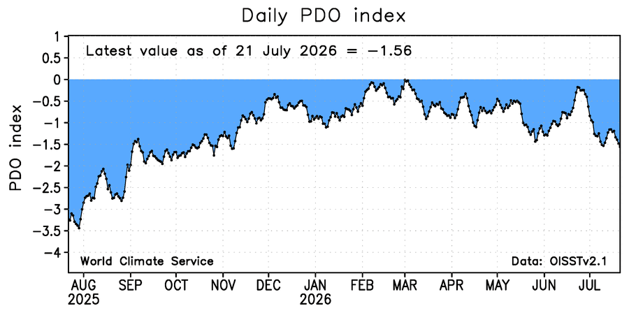
-
Drier air is also filtering in this afternoon as the front clears us
-
That cell that moved thru was a gully washer by you around 9:30. I just got clipped by it. Total of 1.48 in the Davis for yesterday here. edit: rain shower currently and a few more out there for today.
-
Hopefully they are right. I will take my chances with an active stj.
-
 not for rain .......
 -

If you could re-experience ONE winter event....
buckeye replied to cyclone77's topic in Lakes/Ohio Valley
1978 blizz hands down even though the snow amounts were nothing crazy here in mby, the wind and the rapid temp drop made that storm one for the ages. That was basically a cat3 hurricane over land. But what i would find fascinating is to see how the current day models would have handled that storm. How far out they would have begun to see it and when the severity/phasing aspect would have been latched onto. You look at a model like the ukie that loves to forecast phased bombs into the lakes....can't imagine what some of the outputs would have looked like lol. -
Very little activity today too. Probably 90% of the area will stay dry.
-
Do you track things like month-to-date and year-to-date?
-
It's a couple hundreths of an inch at best
-
 0.34" last night, 0.76" on the month. Funny how quickly things turn. lawn was real nice in June. Not so much now. With our annual BBQ party and band this wknd, nobody should be walking around in bare feet.
 -
.27"