All Activity
- Past hour
-

Central PA Winter 25/26 Discussion and Obs
GrandmasterB replied to MAG5035's topic in Upstate New York/Pennsylvania
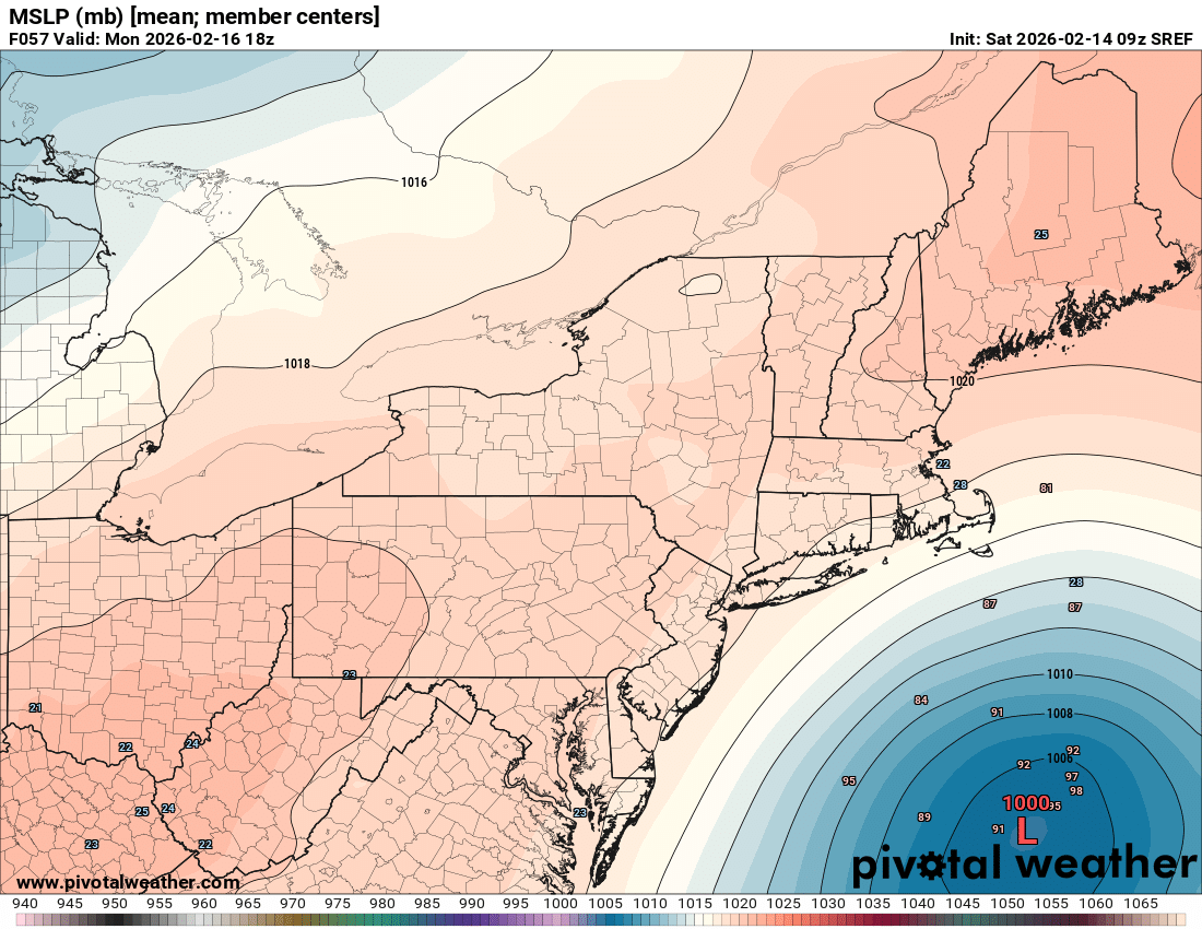
SREFs with an uptick in precip vs. prior run for those looking for model support. (But yes it’s the SREF)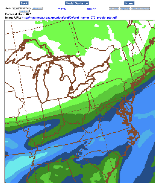
-

Central PA Winter 25/26 Discussion and Obs
Mount Joy Snowman replied to MAG5035's topic in Upstate New York/Pennsylvania
Low of 23. I decided to check in on MU’s twitter feed since he basically mocked the possibility of anything happening here earlier in the week and sure enough he has been ranting about the models again the last couple of days. He is really going through it this winter. -
19.2 for the low. Sunniest spots facing south are down to grass, but most areas still 1 to 2 inches of snowcrete. Should see massive grass gains today.
-
Yeah, to Jax's point, much of metro and points south has looked like a warzone in recent weeks. Almost as if an EF-0 tornado the size of a county swept through. Definitely an historic storm that no one will miss. Hopefully, next year we'll be able to secure more fond winter memories. Wish more people could have had my outcome in the sense we didn't lose power against a better sleet/freezing rain ratio.
-
There’s some good content here but for you to write this type of post on a Saturday morning during coffee time addressing the wall that is Chuck, you need a bourbon and a Prozac.
-
Because it has a cold bias??? Among many other problems lol
-
And 2/14 12z - we're off QPF SERF
-
Agreed with potential like Upton says for high end advisory
-
NOT WITH THAT TRACK ON FEB 15!!! Dude we had this damn debate a few days ago. Yea it was cold, when we had a perfect pacific epo pna ridge. Of course it was cold go back and look at the flow, air was coming straight out of the arctic cross polar and dumping into the Eastern US. And Utah was torching with highs in the 60s! We’ve had that kind of thing before and it was even COLDER! Look at 1977 and 1994! We’ve had high temps near 0 in past years with that kind of direct arctic discharge with snowcover. 30 years ago what we just had would have been even colder Chuck. And the globe didn’t suddenly get colder we were juts lucky to be under the tiny bit if cold real estate! look at the global heights from Jan 25-Feb 5. 70% is still RED Chuck. For the last time this isn’t about what happens when we are lucky enough to have a perfect pac pattern that dumps arctic air over us and we’re in the 30% of the world that’s blue. I know we can still snow them. But what happens the rest of the time??? What about the 70% when we’re under the red? When thickness are now 10-15m higher in the same pattern. You don’t think that makes a difference. You don’t think if the whole thicknesses were a little lower tomorrow or might not tip the scales from rain to snow for some places in this forum? Have you looked at the soundings tomorrow? The whole damn column is cold enough except the boundary where it’s 35-38 degrees. Guess what layer is warming fastest! The boundary. How can you possibly think it’s not making a difference with the marginal storms? So many of our past snows were barely cold enough because we’ve always been on the southern edge of where it snows much in winter. If you’re going to argue warming isn’t hurting us then you need to answer these 3 questions. 1) where did all the marginal snows during hostile pacific patterns go? Why don’t we get snows from perfect track waves during warm patterns anymore? Because we used to. I know. I have a data base of all of them. So what happened? why are perfect track waves doing hostile pac patterns juts perfect track rain now? What changed? 2) why has the median and mean snowfall for DC and Baltimore been declining consistently for 100 years and accelerating in the last 50. Explain it. Baltimore used to average almost 25” of snow and now it’s 19 and likely to fall closer to 16 when it updates next decade! Why? What happened to 30% of our snow? 3) since you’re saying warming isn’t hurting us in these marginal Situations then explain this. All the snowstorms we got during otherwise warm periods from a perfect track wave in the past when it was barely cold enough to snow…take early March 1962 for example. Some places just NW of 95 got 10” but with temps of 33-34 degrees while it was snowing. It just snowed hard enough to overcome the very marginal temps. But it’s warmer now. How would that still be snow if you apply today’s temps to that storm. Now it’s 35-36! The whole column is warmer too. Which is worse because it was probably isothermal so now it has 5000 feet of 35 to overcome instead of 33. How is that still a snowstorm? Or are you saying it’s not warmer? That thicknesses haven’t increased. That thermometers are broken and they’re all lying to us? because you can’t have it both ways. So much of our snow in the past came when it was barely cold enough to snow. So you cannot say it’s warmer but don’t worry that’s not hurting us. You can’t because if you warm is at all we lose so much of our past snow. 1-2 degrees F warmer and so many of those storms I documented get worse. Become 3” instead of 5”. A 3” wet slop becomes just rain! And suddenly it only snows during cold regimes and you say warming has nothing to do with it which makes absolutely no sense logically. How can you warm what was already a barely cold enough to snow equation and say it’s no big deal to our snowfall? Explain that Chuck.
-
As we know this will change, but would love to have a 36-hour crawler. Just let's get it a little further south. It would be luck of the draw to be a big storm ( snow ). We already had one biggie though... Two would be the icing on top
-
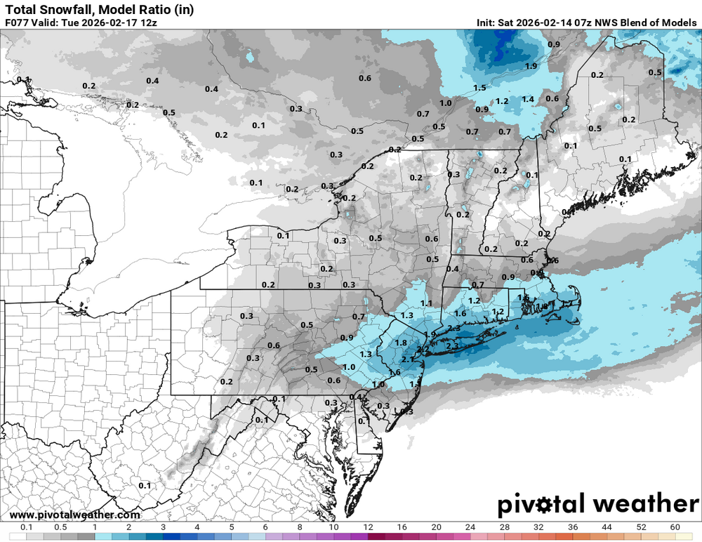
Hopefully we sneak a stat padder 1-3" type event.
-
Easy fix…every balloon sold at Party City should include radiosonde. Kids lose balloons all the time. Imagine all the additional data. As mentioned, we need some enthusiasm from the mesos today. Otherwise, I’ll be in the spring thread.
-
NBM increased
-
Big jump n/w on sref

-
LOL. Where have you been? That forum was shut down many month ago.
-
Euro AI makes the 19th 20th go poof on its approach. But it continues to have an absolute monster crawler, 36 hour storm in the 980s crawling along the southern New England coast. It’s had that for a while I think.
-

Central PA Winter 25/26 Discussion and Obs
pawatch replied to MAG5035's topic in Upstate New York/Pennsylvania
30 degrees this morning. Model's are sure doing a lot of wiggle wiggle wiggle. I guess you southern Pa guys just deal with what the models are going to give you…Good Luck! -
OKX AFD: Operational 00Z GFS and ECMWF continue to come in a bit farther north with the low track. Ensembles still support a low track well south of the area Sunday night into Monday, but the ECMWF ensemble mean is slightly farther north and a couple of mb stronger than previous run. The GFS ensemble mean is generally the same track as the previous run, but also a couple of mb deeper. The respective AI models are also a bit farther north, now introducing some QPF into the forecast area, whereas previous runs did not. This is likely due to the slightly more amplified northern stream shortwave that allows the surface low off shore to strengthen, bringing in more moisture into the region. Chances for at least some minor accumulations have increased. However, if the operational GFS verifies, we could see high end advisory level snow across NYC, Long Island, and NE NJ. Did not want to jump on board with something as drastic as the GFS just yet, but if the northward trend continues, higher snowfall would be expected. Right now, a 1-2" (closer to 1", though locally higher amounts of 2" or slightly higher are possible) is expected for much of Long Island, with all other areas under an inch.
-
 34 and cloudy is their lot
 -

February 2026 OBS & Discussion
sussexcountyobs replied to Stormlover74's topic in New York City Metro
Picked up a dusting of snow overnight. Mostly cloudy 25F -
 That is a significant pattern, especially with average low temperatures breaking records two years in a row. Warmer overnight temperatures often indicate broader shifts in regional climate conditions, not just daytime heat spikes. It would be interesting to compare long term trends to see if this reflects ongoing warming or short term atmospheric circulation changes.
 -
My nephew lives in Roseville, to the NE of Sacramento. One time he and his wife drove a couple hours to Tahoe to see 4-5 feet of snow on the ground, then drove home to 50s and sun. Man, CA makes me jealous
-
2.5” remaining but the sloped, sunny spots have caved.
-

E PA/NJ/DE Winter 2025-26 Obs/Discussion
Ralph Wiggum replied to LVblizzard's topic in Philadelphia Region
^^^ wrt to this, I am just giving my $.02. Lack of data in = lack of data out. If anyone wants to delve into the why's and who's I strongly suggest taking that discussion to the political/o.t. subforum to avoid unnecessary banter here. -
I went outside expecting spring birds chirping and mild south wind. Nope. Thankfully still winter lol