All Activity
- Past hour
-
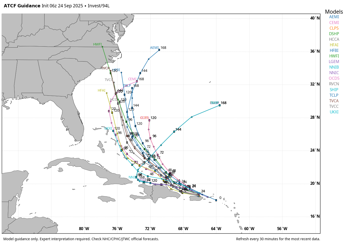
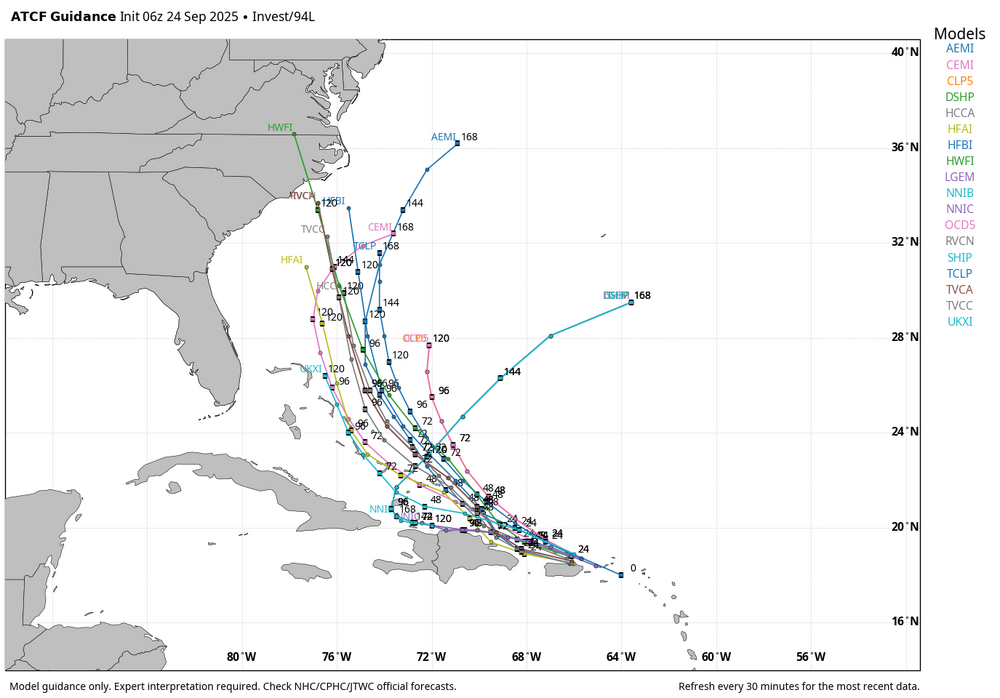
WB 6Z ATCF tracks for 94L.
-

2025 Atlantic Hurricane Season
NorthHillsWx replied to BarryStantonGBP's topic in Tropical Headquarters
Latest HWRF takes a cat 3 into NC from 94L - Today
-

September 2025 OBS-Discussion centered NYC subforum
SnoSki14 replied to wdrag's topic in New York City Metro
Fujiwhara type reaction. Very unique. Not sure what sort of impacts, if any, there would be. -
Good cluster of t-storms entering RI now. Enjoy the big drink to all those out west! Def a few rumbles with those too.
-

E PA/NJ/DE Autumn 2025 Obs/Discussion
LVblizzard replied to PhiEaglesfan712's topic in Philadelphia Region
Take a look at what happens on the 0z models in the western Atlantic. Two hurricanes form simultaneously and get very close to each other. It looks like high pressure will prevent the western one from moving up the coast but still, this could be a very rare situation to observe starting this weekend. -

2025 Atlantic Hurricane Season
Coach McGuirk replied to BarryStantonGBP's topic in Tropical Headquarters
Interesting about Hurricane Gabrielle. Heated straight to Portugal. nhc.noaa.gov/refresh/graphics_at2+shtml/240532.shtml?cone#contents -
Heavy rain starting here now, looks juiced upstream. Had around 1.3 inches overnight last night.
-

2025-2026 ENSO
Stormchaserchuck1 replied to 40/70 Benchmark's topic in Weather Forecasting and Discussion
Warmer October still look likely. Long range models have +EPO, which I have stressed is a connected -PDO pattern, strongly, in October. What I mean is the PDO as an independent variable, not connected to 0-time conditions and influenced by them. It's working for the 2nd year in a row, as the PDO has been strongly negative in both of those October's. -

2025 Atlantic Hurricane Season
WxWatcher007 replied to BarryStantonGBP's topic in Tropical Headquarters
With a trough possibly in SE Canada at the time of closest approach no direct hit is definitely on the table. -
2025 Atlantic Hurricane Season
Coach McGuirk replied to BarryStantonGBP's topic in Tropical Headquarters
I don't expect anything from these two tropical waves. They could become hurricanes but are likely out to sea. -
No rain at home. 42 here this am!
-
2025 Atlantic Hurricane Season
WxWatcher007 replied to BarryStantonGBP's topic in Tropical Headquarters
I think we need to see how the next few weeks play out, but definitely true that most missed the early September peak of the season being historically dead. -
Fantastic fall soaking. 1.2" of light to moderate rain over the past 36 hours.
-
.88” in 30 minutes
-
Any chance of a weak west based Modoki Nino?
-
2025 Atlantic Hurricane Season
Coach McGuirk replied to BarryStantonGBP's topic in Tropical Headquarters
I mean that one coastal low should have been named. 6 inches of rain here and coastal flooding. -
2025 Atlantic Hurricane Season
Coach McGuirk replied to BarryStantonGBP's topic in Tropical Headquarters
Nothing. -
Good lightning with this storm.
-
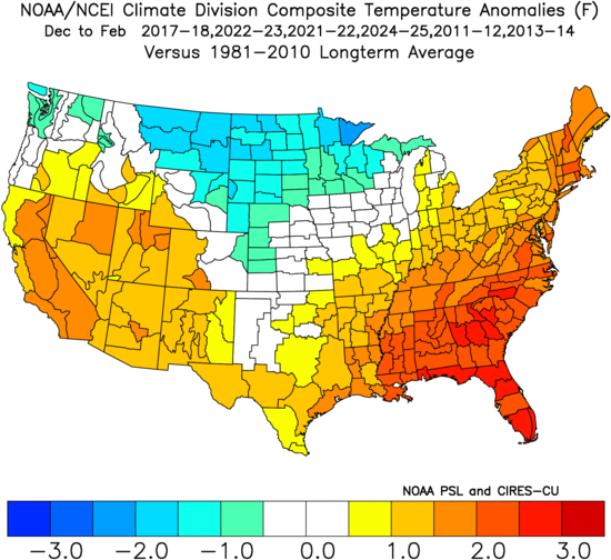
I could see it being a -EPO / -PNA / southeast ridge kind of winter with a few brief but relatively intense cold shots but overall warmer than last year. I've heard that the North Atlantic anomalies signal a +NAO, but if we get some transient blocking in January or even March, we could luck into something. 2021-22 was mostly like that except for Jan and we had chances. I don't even think there was much blocking that year. If we had had Dec 2022 later on, it also could have produced. Something like 2017-2018 or last year is probably the best case scenario. (I'm using 1981-2010 anomalies in this image on purpose. It's just so hard to get a legitimately cold winter now. Even this September is likely going to end up above normal here.)
-
At least the Pacific has perked up this year...maybe that'll help flush out the stagnation in the pattern. Looks like Hong Kong getting knocked around by Ragasa...
-
Rain hitting the roof sounds good. Its been a little while.
-
Aaaannnnndddd there's lightning in Litchfield County CT...
-
I still think it's too early to get a great sense for anything in the US. This is a really complicated steering pattern, in large part driven by the proximity of 93L and 94L. Folks along the coast should definitely pay attention to this one, though there's no real need for concern yet. The Euro trend toward a strong 94L is interesting though. That's definitely something to watch.
-
If there is going to be a period of more widespread showers, it looks to be very early Thursday. Otherwise, there will be some big winners with the scattered convection each day (especially Thursday), but it doesn't look to be particularly widespread.