All Activity
- Past hour
-
31 for the low. Beautiful nonetheless. Sunny, birds chirping. Buds starting to open up into a light green mist in the canopy.
-
Well I should know better. Got all excited for the what was forecasted a decent soaker for today and planted some containers on the deck. Was also going to lay down some grass felt. And poof 90% with a trace of rain shows up. So that in my mind translates to England spittle. Glad I did not get to laying any grass felt at least I can just water my containers. I will say one thing though. After several years of dealing with a lack of rain I have curated some amazing drought tolerant perennials in my gardens. Sedums which look like they should need a lot of water love the dry. And got to love Catmint. Gets you green with small blooms.
-
I‘m thinking after the 10th or so
-
Damn. We bailed on our plans for today and it looks like the weather will hold until at least lunchtime. I hate when I do shit like that.
-

Central PA Spring 2026 Discussion/Obs Thread
Mount Joy Snowman replied to Voyager's topic in Upstate New York/Pennsylvania
.05” of rain and current temp of 51 is the low. Great weather for 4-6 year olds to play baseball this morning. -
"big" may be subjective... "when" also not so clear. I'd give it the first full week of the month to be safe. Most of what we are seeing in the pattern forcing appears to be -NAO/West orienting. The index prognostics have that relaxing during the first week... The 00z Euro decided to go bonkers with a new +PNA right as that is happening, though. And that really delays and complicates the exit strategy from the -NAO. If that has legs then an unseasonable trough delays any warmer transition. We'll see. The GEFs/GFS diverge from that idea and instead go toward neutralizing most fields. If that's the case, we go back to modestly AN. It's spring. Variance headaches are typical -
-
Doesn’t seem like too much rain this coming week . Possibly early May better big warm up
- Today
-
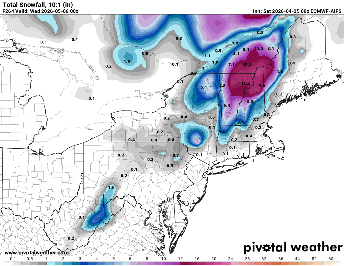
Far out but Euro AI crushed Northern New England

-
And probably the Berkshires... Plenty of rain for us and cool to cold temps.. we take!! Might have to go for a drive next weekend to see some snow tim kelly also posted this.. we take and take again

-
Sneaky cold am....again. 29F for the low, light frost.
-
For snow in far NW NY state?
-
27.5° Make it stop
-
Frosty AM. 29F
-

2026-2027 El Nino
snowman19 replied to Stormchaserchuck1's topic in Weather Forecasting and Discussion
Here comes more WWBs. I think this is going to be a record-breaking TC season in the PAC…. -

Potential Sever Weather Outbreak 4/27/2026
andyhb replied to pen_artist's topic in Lakes/Ohio Valley
Very strong wording in the latest D3 for Monday, got the feeling this ends up as a D2 MDT. -
Interesting week ahead hmmm
-
The big rains modeled for today into Sunday have collapsed imby. 1+ inches modeled, now down to less than a 10th. It's brutal trying to break out of a drought. A few years ago it seemed it wouldn't stop raining. Now it won't start.
-
These models can be real shitty with severe,just like today.Nashville has been telling people for the last few days to not let your guard down today,which the models have been showing with basically wind dmg.We didnt get next to nothing,not even a drop of rain
-
Wouldnt trust any model right now in our parts,GFS even looks much better tonight,east of the Cymberland,late Monday
-
Definitely some interesting days ahead. NAM yes the egg nog drunk NAM at its end which is poor resolution paints conditions into the area west/middle TN. Conditions that anything that can take advantage of that environment could be quite rambunctious.
-

Texas 2026 Discussion/Observations
canderson replied to Stx_Thunder's topic in Central/Western States
Tor warning through Gilmer. Gilmer is the tornado magnet of ET lately. -

Central PA Spring 2026 Discussion/Obs Thread
Itstrainingtime replied to Voyager's topic in Upstate New York/Pennsylvania
Steelers pick Allar in the 3rd round. -
IAD 87 afternoon and 61 eight hours later
-

Occasional Thoughts on Climate Change
TheClimateChanger replied to donsutherland1's topic in Climate Change
-
I'm glad, I'm going to that tomorrow and wasn't looking forward to that forecast