All Activity
- Past hour
-
Gfs says otherwise.
-
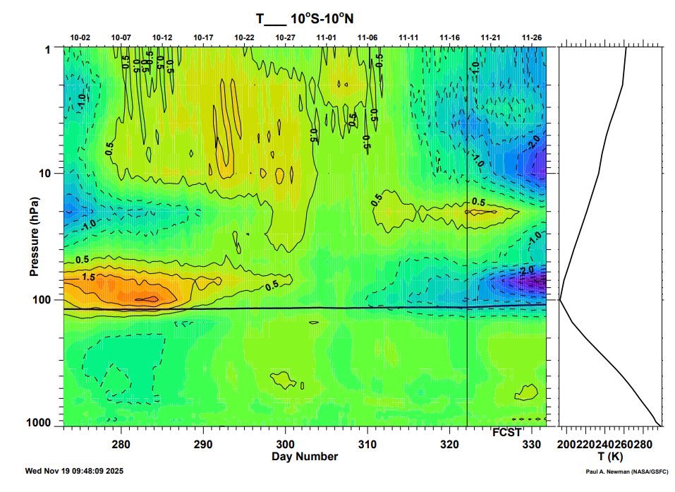
I saw this graphic on X from Eric Webb showing the cooling lower stratosphere in the tropics. It seems the trend in strengthening the MJO is likely related to models catching on to the effects of the stratospheric warming as well as the final warming at the south Pole (strengthened Brewer Dobson circulation). Perhaps this is what will finally allow us to see a robust MJO through phases 7-8-1.
-
26
-
No surprise. Dallas is getting demolished by waves of torrential rain. DAMN I'M A GOOD FORECASTER! The rain has completely missed us tonight, which in one sense was good for me because it means I got to go out deliver. I am now pretty sure that this curl pattern, which I have learned to recognize, when we have a Pacific front and an upper level low - The Infamous Curl Pattern, in which rain curls around the Austin Metro and around Buda, means little to no moisture for us, and Dallas, Oklahoma and Missouri had better be building an Ark, because this system is very powerful and all of the rain will be channeled across Dallas, probably dumping over a foot of fresh rain flooding the Trinity River and it is gonna take a hell of a lot more than Neo to conduct all those water rescues into Thursday and Friday. A hell of a lot of heavy rain is heading right for Little Rock, AR! Oklahoma is at grave risk as is parts of Missouri. Louisiana isn't out of the woods, not by a long shot. I'll eke out maybe a tenth to a third of an inch, That's all. This is a BAD PATTERN for Austin. I have seen this so many times its not even funny. Welcome to La Nina. This low sun season drought is gonnabe so bad for Texas come the hell summer of 2026 in which the Nina will only deepen. No rain at all for us. Ag will suffer and collapse. Jugs of water will be worth incredible amounts of money by 2030. Food will become scarce as the ugly specter of holodomor starts to loom. This may be a damn good time to get out of the Southwestern US. Where there is no water, there is no life. REMEMBER, BEFORE MOVING TO AUSTIN - THIS REGION IS CURSED. WE MISS MOST OF THE RAIN. Might want to go to New Orleans instead. They are in an historic convergence zone. They get all the winter rains, then in the summer and fall in a good year every last tropical cyclone will ring their bell. Harvey was wonderful! They had plenty of rain that year!
-
Euro
-
From Dr. Simon Lee, for those who don’t know, he’s a college professor of meteorology and an expert on the stratosphere, has written many papers on it. Here’s what he has to say:
-

Fall 2025 Medium/Long Range Discussion
A-L-E-K replied to Chicago Storm's topic in Lakes/Ohio Valley
Looking mild and boring, p rough - Today
-

November 2025 general discussions and probable topic derailings ...
ineedsnow replied to Typhoon Tip's topic in New England
EPS also looks good! We take! -

Central PA Fall Discussions and Obs
Voyager replied to ChescoWx's topic in Upstate New York/Pennsylvania
Dense fog and 28 degrees this morning. Wasn't exactly expecting a foggy morning. -
Central PA Fall Discussions and Obs
Voyager replied to ChescoWx's topic in Upstate New York/Pennsylvania
Well, if it would snow, I'd rather it on the weekend when I'm not out driving the big truck... -

Texas 2025 Discussion/Observations
Powerball replied to Stx_Thunder's topic in Central/Western States
DFW apparently did set another record high minimum yesterday with a low of only 68*F (the prevoous record was 67*F). -

Pittsburgh PA Fall 2025 Thread
blackngoldrules replied to TheClimateChanger's topic in Upstate New York/Pennsylvania
As long as Bob Nutting doesn't control the weather, maybe he have a shot. Sent from my SM-S931U using Tapatalk -

Major Hurricane Melissa - 892mb - 185mph Jamaica landfall
Windspeed replied to GaWx's topic in Tropical Headquarters
They transmit data several times a second until they splash down to get a real-time measurement of the column they're falling through. In this particular case, the peak of the gust occurred at 657 ft, but the gust most likely continued through decent into splash-down being that low. I haven't read the entire data transfer, however. That being said, there is no bearing on height. It could have occurred even closer to splash down, given the high frequency of the data transfer. 657 ft is pretty close to the surface, though. Within 20 seconds to splash down at 10m/s.. -

November 2025 general discussions and probable topic derailings ...
8611Blizz replied to Typhoon Tip's topic in New England
Euro has some bangers on there... -

December 2025 Short/Medium Range Forecast Thread
John1122 replied to John1122's topic in Tennessee Valley
Saw a met today throwing out 1983 as a potential December analog. That was maybe the most frustrating winter month ever in my area at least. It was bitter cold, one day of warmth as a cutter passed, then ice box again. It was below zero on Christmas day. It warmed from the low 20s to the 50s early month, and rained 2 inches. Was in the low 40s and low 20s for a day, then it warmed into the 60s and rained an inch. It got very cold on the 19th, snowed a little over an inch with highs in the lower 20s on the 20th. Warmed up to 53 on the 22nd and rained nearly an inch, the bottom fell out and we got a dusting of snow on the 23rd and 24th, it was low single digits for highs on Christmas, with teens below zero lows. Dry as a chip. The high was 7 on the 26th, 24/2 on the 27th, it shot up to 48 on the 28th and rained again, just over an inch. That was ahead of another super potent cold front. Temps crashed behind it, it was 44 at midnight the 29th, and it fell to 2 by 11:00pm. It was negative 7 the morning of the 30th, and highs on New Years eve were in the teens. Through all that week of cold, we got around an inch and a half of snow but with that inch of rain in the few hours we were above freezing. All in all, December was around 8 to 9 degrees below normal, we had almost 7 inches of precipitation, but barely managed 2 inches or so of snow to show for it, with less than that in some areas. It's the ultimate month that shows that no matter how perfect things should be with well BN temps and well AN precip, we're prone to getting shafted on snowfall. -
good win for the Caps - it's quite a concept: score more goals than the other team.
-
Looks like all MD AWOS METARs have returned, except for KMTN. This site has taken manual METARs in the absence of the AWOS METARs.
-
.thumb.png.4150b06c63a21f61052e47a612bf1818.png)
November 2025 general discussions and probable topic derailings ...
HIPPYVALLEY replied to Typhoon Tip's topic in New England
Yup, that's more likely than a SNE storm in that time frame. -
 Yep. 12° at WXW2 last night and down to 19.8° so far tonight.
 -
chill yall. this is a thread to talk about ENSO, not a thread to belittle people because of their biases warm/cold. jeez
-
Yes because being rude is a great way to get your point across
-
stopped by pizza empire near goldsboro on my way back to Delaware.

-

November 2025 general discussions and probable topic derailings ...
H2Otown_WX replied to Typhoon Tip's topic in New England
Meh, how'd those cloud physics workout for you? -
30 now, some areas nearby dipping into the 20s
-
My climo isn't exactly December friendly but lately winter isn't friendly period. That snow the first week of this month was half of my total last year. That ain't climo, that's just stupid lol


