All Activity
- Past hour
-
 Despite being on the edge of the good stuff, still have picked up 1.5 more and steady -Sn still. Planning to take the groomer out tonight at 430, our club president plugged in the block heater cause those old Perkins Diesels are numb in the cold.
 -

Central PA Winter 25/26 Discussion and Obs
canderson replied to MAG5035's topic in Upstate New York/Pennsylvania
Snow is melting off my sidewalk - nice to see actually -

The “I bring the mojo” Jan 30-Feb 1 potential winter storm
BooneWX replied to lilj4425's topic in Southeastern States
Correct. @wncsnowshared the latest data earlier, it was a classic west of I-95 footprint. We’ll see a new run later today and it’ll be interesting to see if it remains amped. Edit: it aligned really well with the NBM -
 Yup. And there’s your double digits. You’re gonna end up comfortably in your 10 to 14 range.
 -
 Moderate snow
 -
Heavy westward lean.
-
 Got up at 11 this morning, and it's snowing again. 2 inches new in Westfield the last few hours, but looks to be wrapping up soon. Spying trends for next weekend...
 -
 14.1" storm total w/clearing twice. About 12-13 depth. if anyone has reports wait till the end of the day after its all said and done so i can get a final. will have to wait till tomorrow for cocorahs and coop to get todays stuff.
 -
I'll be 55 this year, and I expect to have the same feeling when I'm 85.
-
 this would be excellent.
 -
 1.5” new since about 11a
 -
 Idk, but I know late in the game it had the enhanced bands se of me, which worked out.
 -
 Yeah, I’m expecting nothing today. I think outside of the OE areas like Scooter and Norwell area, the general area of “accumulating snow” is way to widespread. my guess is most of eastern ma outside of the favored ocean effect zones won’t see shit
 -

Possible coastal storm centered on Feb 1 2026.
dryslot replied to Typhoon Tip's topic in New England
Lot of spread, But some huggers.
-
I’m 40 but I still get a lump in my stomach before these runs lol .
-
Good thing is we're starting at under 120, so should know something pretty quick
-
Assume we are tracking the cold in this thread. 24.0 and the wind is picking up. Models are all over the place on lows tonight, but the favored areas may make a run to 0.
-
For sure. I'd rather have the euro fam in our corner than the gfs fam.
-
 I think Nam brought it past you for a time. 3K Nam was decent and even that was maybe too far west. I’m usually decent on CF placement forecasts but this was further SE than I thought for sure.
 -
Euro is running
-

The “I bring the mojo” Jan 30-Feb 1 potential winter storm
wncsnow replied to lilj4425's topic in Southeastern States
Thats not what the last run showed but its possible -

Possible coastal storm centered on Feb 1 2026.
ineedsnow replied to Typhoon Tip's topic in New England
Euro starting up -
I know we obviously want to see as much guidance on board as possible, but the euro / ai / cmc sniffed out yesterday’s storm first as well. We certainly have the best camp in our corner - especially at day 5. Plenty of time to reel this fish (storm) in. If in 48 hours most guidance is still OTS, we will have to re-evaluate. But as bob chill said, an in between solution can still be a 2-4/3-6 of fresh pow type clipper to add to our snowpack that’s going nowhere.
-
This is one of those days where the radar improves each hour as it fills in
-
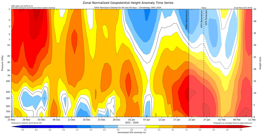
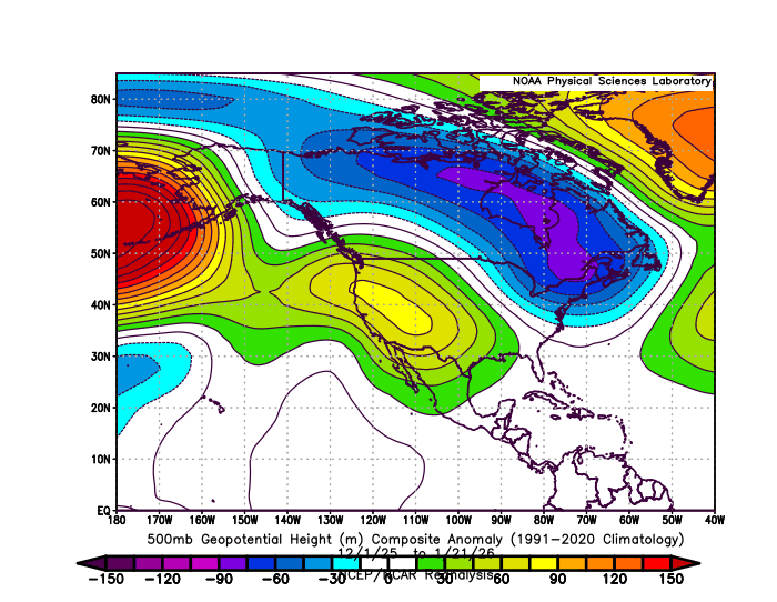
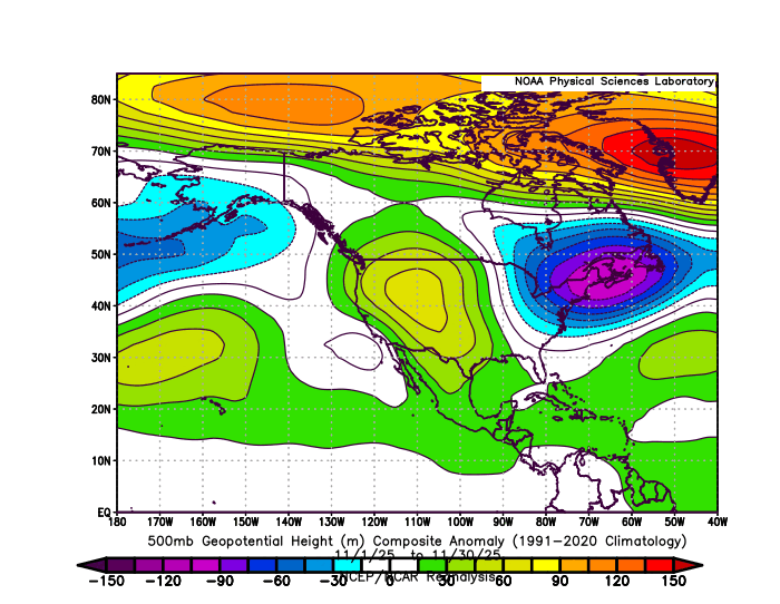
The unusually early SSW event leading to the disruption of SPV in late November was possibly caused by an interaction between the record low Arctic Sea ice near the Barents and Kara regions and the -QBO. This event seems to have caused key features of the November 500 mb pattern to lock in for the winter. It’s also unusual for some many elements of a November pattern to become amplified and persist into the winter. The current activation of the STJ and the recent largest snowstorm since January 2022 for spots in the Northeast is probably the result of the forcing finally shifting east of the Dateline. https://agupubs.onlinelibrary.wiley.com/doi/10.1029/2025JD044403 one model, HadGEM3-GC31-MM, has a statistically significant equatorward shift in vortex latitude, deceleration of vortex winds, and increase in sudden stratospheric warmings. Its response is found to be highly state-dependent, significant only in the easterly phase of the quasi-biennial oscillation (QBO). Though we cannot comprehensively conclude why models simulate this range of responses, our analysis does highlight areas for consideration in future work to better constrain the stratospheric response to Arctic sea-ice loss. We explore the role of ensemble size, resolution and basic state, including zonal-mean winds in the polar and midlatitude stratosphere and upper troposphere, as well as the QBO. https://alaskaclimate.substack.com/p/december-2025-arctic-climate-summary For the second December in a row, the Arctic-wide average sea ice extent was the lowest on record in all of the major sea ice analyses. In the National Snow and Ice Data Center analysis, the December 2025 average extent was 11.22 million km², which is about 15 percent lower than the late 20th century December average. The Barents Sea and Baffin Bay had the lowest December extent on record, and northeast of Svalbard the average pack ice edge was north of 81°N November 2025 and December into January 2026 500mb composites