All Activity
- Past hour
-
beautiful spot, feel free to dump some pics in banter friend
-

July 2025 Discussion-OBS - seasonable summer variability
steve392 replied to wdrag's topic in New York City Metro
72 in Paramus and just oppressive already. -
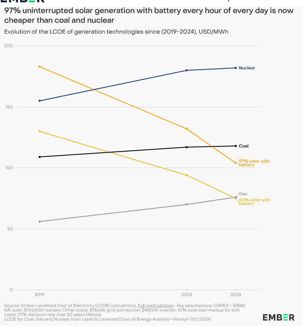
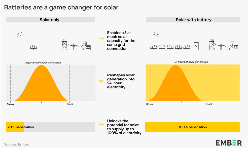
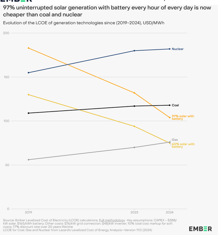
This is an interesting report. With the decrease in battery prices, 24-hour electricity from battery/solar is becoming cost effective in sunny locations. Projects are already being developed around the world and costs are only going to drop in the future. A game changer potentially. https://ember-energy.org/latest-insights/solar-electricity-every-hour-of-every-day-is-here-and-it-changes-everything/
-

July 2025 Obs/Disco ... possible historic month for heat
Damage In Tolland replied to Typhoon Tip's topic in New England
Smoky today . May cap temps -
Heat Advisory URGENT - WEATHER MESSAGE National Weather Service State College PA 134 AM EDT Tue Jul 29 2025 PAZ019-025>028-034>036-045-046-049>053-056>059-063>066-292100- /O.NEW.KCTP.HT.Y.0006.250729T1500Z-250731T0000Z/ Southern Centre-Blair-Huntingdon-Mifflin-Juniata-Bedford-Fulton- Franklin-Southern Clinton-Southern Lycoming-Union-Snyder-Montour- Northumberland-Columbia-Perry-Dauphin-Schuylkill-Lebanon- Cumberland-Adams-York-Lancaster- Including the cities of Huntingdon, Pottsville, Williamsport, Lebanon, Berwick, Lancaster, Gettysburg, Lewisburg, Bedford, Carlisle, Selinsgrove, Harrisburg, Danville, Shamokin, Mount Union, Lock Haven, Altoona, York, Mifflintown, Bloomsburg, McConnellsburg, Sunbury, Lewistown, Hershey, Newport, Chambersburg, and State College 134 AM EDT Tue Jul 29 2025 ...HEAT ADVISORY IN EFFECT FROM 11 AM THIS MORNING TO 8 PM EDT WEDNESDAY... * WHAT...Heat index values up to 104 expected. * WHERE...A portion of central Pennsylvania. * WHEN...From 11 AM this morning to 8 PM EDT Wednesday. * IMPACTS...Hot temperatures and high humidity may cause heat illnesses. * ADDITIONAL DETAILS...This level of heat affects anyone without effective cooling and/or adequate hydration. Heat-related impacts are likely in some health systems, heat-sensitive industries and infrastructure. PRECAUTIONARY/PREPAREDNESS ACTIONS... Drink plenty of fluids, stay out of the sun, and check up on relatives and neighbors. Young children and pets should never be left unattended in vehicles under any circumstances. This is especially true during hot weather when car interiors can reach lethal temperatures in a matter of minutes. Once you park, STOP, LOOK, LOCK.
-
I guess they think the people here are immune to the effects of heat.
-

July 2025 Discussion-OBS - seasonable summer variability
wdrag replied to wdrag's topic in New York City Metro
No thread from me on the around 100F (near record) heat vicinity NYC-EWR next two days---this July thread suffices. No thread from me on the 20z Wed-20z Friday probably 1-4" needed short term rainfall near and northwest of I95...isolated higher possible. Mainstem flood threat minimal. However several small area FFW possible Thursday CT/NYS/NNJ-LI, especially if SVR develops? If it looks worse tomorrow morning, will thread but for now relatively routine: fun for us but nothing extraordinary yet projected. SPC has marginal risk Wednesday and no SVR Thursday. That may need adjustment with time. WPC has a slight risk excessive Thursday and I like that---just not willing to overcommit a thread at this time. This based on on modeling seen through 00z/29 and WPC products available at 553A/29. Wish you a safe day. -

July 2025 Discussion-OBS - seasonable summer variability
IrishRob17 replied to wdrag's topic in New York City Metro
A number of us can't figure out how to easily post photos here anymore and there you are with a video... -
Textbook -IOD developing
- Today
-

July 2025 Obs/Disco ... possible historic month for heat
ineedsnow replied to Typhoon Tip's topic in New England
6z 12k Nam is meh. 3k looked like it could be fun -
July 2025 Obs/Disco ... possible historic month for heat
ineedsnow replied to Typhoon Tip's topic in New England
Euro op was fun to.bad it won't be right.. then at the end of the run a cane hitting the Gulf with a weaker storm that looked to be heading for the east coast.. -

2025-2026 ENSO
Stormchaserchuck1 replied to 40/70 Benchmark's topic in Weather Forecasting and Discussion
Did someone say continuous +AO? -
A good part of the year so far, even though we're going to have to pay for the string of wet months at some point in the future. Just as expected, the 6th consecutive wet month. Currently at 29.08" for 2025, just less than 20" needed to at least tie the 10th wettest year on record (48.99" in 2018).
-

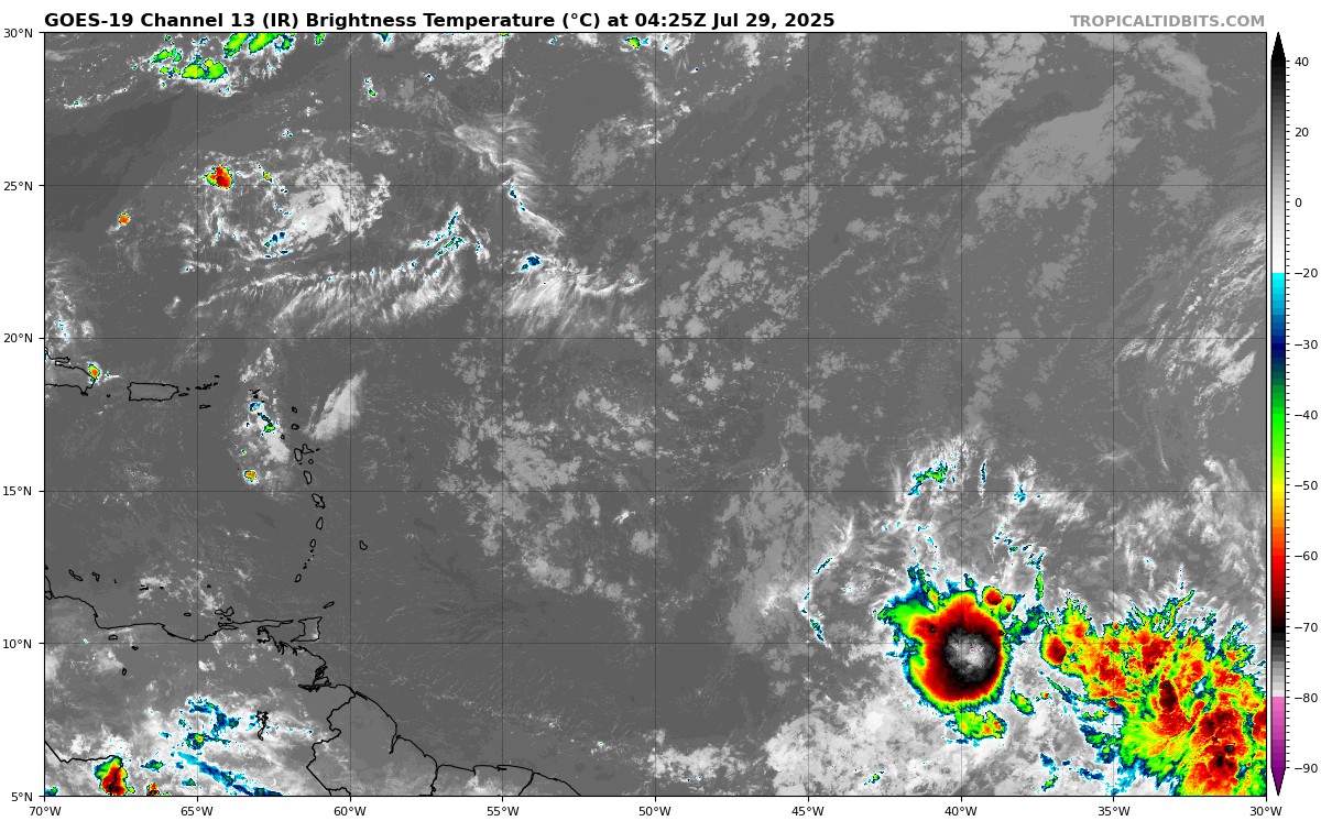
2025 Atlantic Hurricane Season
tiger_deF replied to BarryStantonGBP's topic in Tropical Headquarters
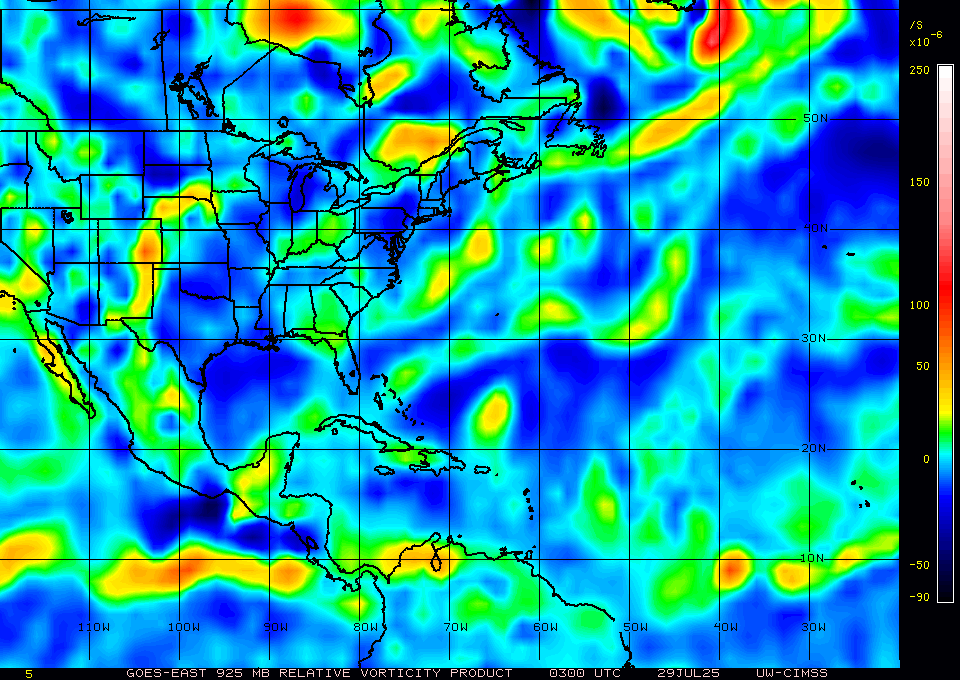
As hostile as the basin state has been for many weeks, the tropical wave at 40W sure is looking good tonight. Lower level vorticity has been increasing dramatically over the past 6 hours and the convection is some of the healthiest I’ve seen in the MDR. Will likely get sheared apart closer to the islands (and the fast background flow will make any consolidation difficult ), but it’s certainly worth keeping an eye on.
-
2025-2026 ENSO
Stormchaserchuck1 replied to 40/70 Benchmark's topic in Weather Forecasting and Discussion
Wonder if we'll start to see this typical La Nina Fall pattern as temperatures start to descend into August -
No, give me an early 2000s August with 40s at night in NNE.
-

July 2025 Discussion-OBS - seasonable summer variability
psv88 replied to wdrag's topic in New York City Metro
The increased sharks are also eating a lot of the fish… -

July 2025 Discussion-OBS - seasonable summer variability
weatherpruf replied to wdrag's topic in New York City Metro
was bearable offshore. fishing sucked, as usual. 2 keeper fluke in 14 hours. a couple ling, and one sea bass for each of us, which is the limit in nj. not a soul on raritan bay, in the middle of summer, in july, with perfect conditions.....they really have accomplished their goals with all the limits....people have just quit fishing. we did see several trawlers.....a whale and a ton of small sharks....not dogfish, but real sharks. -

Spring 2025 Med/Long Range Discussion
KakashiHatake2000 replied to John1122's topic in Tennessee Valley
oh nice it looks like it really fell apart up there -
The one aspect of Colorado weather I'll never get adjusted to is when temps start to drop right after sunset, then randomly go up later in the evening.
-
Been up in Banff/Alberta for the week and of course have missed all the fun shit back home.
-
a bit of the crescent moon with some terrific clouds
-
Radar says 3.5-5.0" was at Romulus/DTW airport and maybe 3.5-4.0" at Fraser/Mt Clemens, northeast of Detroit.
-
The first round of Kentucky storms gave me some pretty heavy showers and frequent thunder. Looks like more upstream but it's weakening some.
-

2025 Short Range Severe Weather Discussion
OrdIowPitMsp replied to Chicago Storm's topic in Lakes/Ohio Valley
MSP had a 60mph gust. Heavy rain, good light show, quality nightcap.