All Activity
- Past hour
-
Takeaway from that is: Use Caution and keep expectations in check and under control.
-

Rise of the Machines: January 18-19 Winter Storm Obs Thread
Sey-Mour Snow replied to WxWatcher007's topic in New England
Ya not implying you, I know your name well, that’s why I said newbies. Congrats on the jack! -

Pittsburgh/Western PA WINTER ‘25/‘26
Rd9108 replied to Burghblizz's topic in Upstate New York/Pennsylvania
My brother is already asking me about a snow storm this weekend already. I hate social media.... -
Well at least we have to start a Part 2 of the January long range thread?
-

E PA/NJ/DE Winter 2025-26 Obs/Discussion
Ralph Wiggum replied to LVblizzard's topic in Philadelphia Region
Not this far South tho and not with a 1052hp pouring S. I dunno about this one. I was just about to post, and I dont want to deflate hopes, but as much as some folks are saying this Nina is acting different, it really isnt imho. And this week is a classic example of a strong NS and pv outbreak with the suppressed look and Southern areas cashing in. I hope im wrong and the AI models 'know something", but suppression has always been a major concern for us over the next 7-10 days. Central mid Atlantic is likely the jackpot zone and should bullseye this one....they deserve it. They should start a thread tbh. I just hope we dont smoke cirrus in this one while Richmond get 16". Another 2-4" storm for my area is perfectly fine with me. -
I think the point earlier in the thread that the AI moves toward the mean, and has problems with the anomalous was a great point. It's only as good as the data used to train it.
-

Rise of the Machines: January 18-19 Winter Storm Obs Thread
Go Kart Mozart replied to WxWatcher007's topic in New England
Yessir, I skied from our hood to Whitney and back, 4.75 miles and a helluva workout. Edit - that was yesterday. -
.thumb.png.4150b06c63a21f61052e47a612bf1818.png)
January 2026 regional war/obs/disco thread
HIPPYVALLEY replied to Baroclinic Zone's topic in New England
Cold and dry next weekend is the likely outcome. -
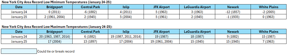
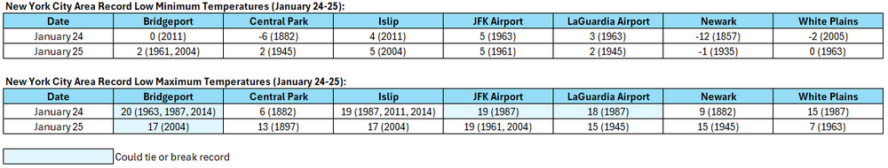
Only a few locations could tie or break record low maximum temperatures. Record low minimum temperatures are too low.
-
NAM extrapolation is a weenie game. But I do like the position of the PV on the 12 Z run. Would not have been suppressed imo.
-
Due to much colder 2 week forecasts vs how it looked on Friday, gas is now up an incredible 19%!! If anywhere near this rise were to hold til the close, this would likely be the largest % daily rise in years:

-
The fun question is weather the AIFS will outperform its ensemble at this range. The ensemble is quite different for our forum area. One thing that many models have missed over time is that when we have a hp funneling cold down west of the Apps, many models will often miss that the actual surface is below freezing. Depending on the sequence that this arrives, the scenario exists that cold air could get trapped in the eastern valley. That is why the model difference below is important. The AIFS has changed quite a bit since 18z w/ a more amped cutter while the AIFS EPS has remained fairly steady. The ensemble mean (rightly or wrongly) smooths out that amped look. If the mean is correct, then the heat transport northward(moisture) will be less and cold air at the surface could be trapped. If the AIFS is correct....liquid drops for almost everyone but NW TN.
-

Central PA Winter 25/26 Discussion and Obs
Jns2183 replied to MAG5035's topic in Upstate New York/Pennsylvania
I remember laughing out loud when after all the damn hours I spent collecting daily data for NAO, PNA, AO, GBI, MJO, a couple other indicies going back to 1950 and running all the multivariate time lag correlations that at most those indicies explained roughly 6% of snowfall variance in our area. Further, that if I could have a super computer that held infinite historical data it would be a miracle if I approached 40%. So much of our storms come down frankly to dumb luck and pulling the slot machine handle. That said it isn't a slot machine, and our luck the past 5 years has rivaled the 1950s for worst luck ever. Eventually the luck will change. This weekend is as good as time for it to change as any I've seen. Sent from my SM-S731U using Tapatalk -

January 25/26 Jimbo Back Surgery Storm
Brick Tamland replied to Jimbo!'s topic in Southeastern States
I like the Google model. Looks somewhere in the middle of the road with the AI models and the OG GFS and Euro. Probably get a mixed bag of things in central NC with more snow the farther north you are to more ice the farther south you are. Pretty much a classic NC witnter storm. -

Rise of the Machines: January 18-19 Winter Storm Obs Thread
cut replied to WxWatcher007's topic in New England
Spent an hour on Pequnock (sp?) rail trail this morning - it was absolutely amazing. Snow on everything. -

Pittsburgh/Western PA WINTER ‘25/‘26
Burghblizz replied to Burghblizz's topic in Upstate New York/Pennsylvania
Several nice bands drifting in from the west -

January 2026 Medium/Long Range Discussion
soadforecasterx replied to snowfan's topic in Mid Atlantic
Both Ai models are the ones that locked in snow for us when all other models did not. From what i remember those locked in around that window 84-96 hours. They maybe the way to go now. Believe @Ellinwood can speak to that. -
I followed the storm up in New England this past weekend. Both AIs were extremely persistent with bringing snow into southern New England when most guidance, including the euro were pretty far out to sea. Good study for our area. hell they even named their storm thread “rise of the machines” lol
-

Rise of the Machines: January 18-19 Winter Storm Obs Thread
TheSnowman replied to WxWatcher007's topic in New England
I've been measuring Snow since 2002. 6 Hour Rule. Board. The Whole thing haha. A "Newbie" hahaha. I wanted to show One area that had 7.25" Compact Total JUST so no one can say "Did Cory REALLY get 7?" I could have been a total slant sticker Biotch and said "7.25" Compact Total! See! Here it is! 8" Storm Total!" But Friends Don't Let Friends Lie about their snow totals. And TRUST ME, with the Jackpot being 7.4" in Coventry, I Desperately Want to have my ONLY 2nd Jack of All-Time. -

Rise of the Machines: January 18-19 Winter Storm Obs Thread
WinterWolf replied to WxWatcher007's topic in New England
19.75” on the season so far here. -
enjoy the ice storm, powerball
-
Agreed. Especially since they are still 'learning as we go'.
-
Mid Atlantic crew are hoping the AI models are right... obviously they are further north. Will be interesting to see which way things go the next couple of days.
-
I’m used to storms on my bday. Jan 25th is one of those it’s wants to snow days
-
ok ok...people are scared. I'll give yall till after 12z tomm? I don't want the storm to see the thread until then because that will be before it's already on the way.