All Activity
- Past hour
-
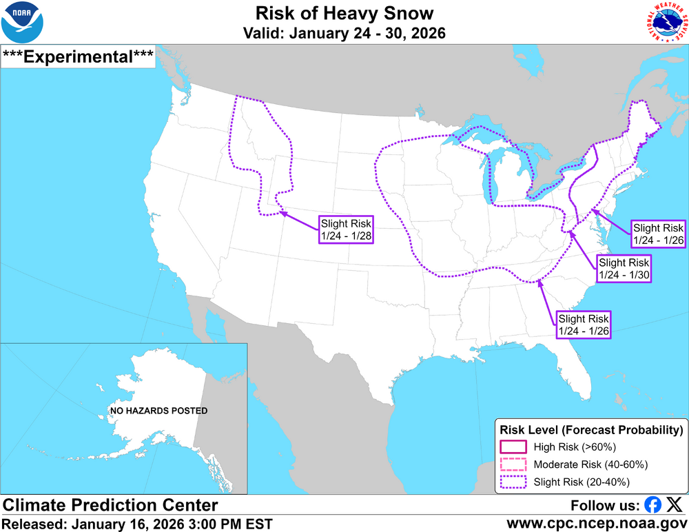
CPC biting on the trends here
-

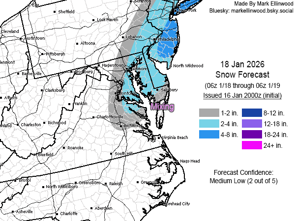
Storm potential January 17th-18th
the_other_guy replied to WeatherGeek2025's topic in New York City Metro
This forum is talking itself into not one, but two accumulating events this weekend. Ill go out on a limb (and it isnt much of a limb) and say NYC will get exactly zero accumulating snow this weekend. The first storm will need elevation and cold. The second storm is the same grazer it has been for days. -
NAM is terrible for Sunday. Looks like NW areas get hit pretty good on Saturday and Sunday is a miss. Ah well, at least someone should getting some snow on Saturday.
-
cloudy and cold, it's like we have been transported to the Great Lakes except without the snow on the ground.
-
Caught me completely off guard when I got the notification. Haven't been paying attention to anything weather related the past 10 days. Looking like a general 3-4" possibly iso 5-6" in & around Orange County. Sunday/Monday looks like a non event, maybe some lgt accumulation along the immediate coast/ E LI
-
I'm thinking about declaring myself done with winter and "over the cold", and thus ready for spring. Prob make the decision here in a few days.
-

Storm potential January 17th-18th
CPcantmeasuresnow replied to WeatherGeek2025's topic in New York City Metro
Nice look for the HV too. Should be all snow here. -
Yes, that all makes sense as to the reasoning on how to organize the info within the disco. Thanks for additional background! It seems that any changes are always well thought out and include feedback. Hope my initial reaction didn't imply I doubted that process occurred. Far from the case.
-
How many times have we heard this one, just amazing how none of these storms pan out.
-
First crack at Sunday... went pretty aggressive with a strong lean on the Euro+GFS AI guidance given how crazy consistent they've been with the track+QPF, with much less consistency among the traditional models. Southern and eastern areas dealing with some surface temp issues while western edge could change drastically if the system ends up weaker/more progressive than my forecast. Lower than normal confidence with this map.
-
Every six hours we pull out the sorting hat.
-
Looks like EPS trended the boundary more south. Good for now, but don't want too much suppression (still unlikely)
-

First Legit Storm Potential of the Season Upon Us
CoastalWx replied to 40/70 Benchmark's topic in New England
Yeah every model kept coming west. Gfs of course back then was lagging. -
Appreciate it, honestly I haven’t been looking too hard - just doing a little light complaining lol. I would def be happy with a half inch.
-
You're in on it for Sunday on the AI guidance. Hopefully the op runs keep ticking NW/expanding the precip field the next few cycles.
-
Something to watch tonight for us snow starved weenies. The HRRR is trying to bring a band of rain/snow mix and some minor accumulations in the upper foothills
.thumb.png.bc55bc6d6307aa86995efefc401bf0e1.png)
-
The short-range models completely missed this little low or whatever it is.
-
Good luck gentlemen! Headed to Japan next week, hope I’m talking about feet of snow while I’m skiing out there. Maybe I’ll remember to take pics for once ha!
-

First Legit Storm Potential of the Season Upon Us
SouthCoastMA replied to 40/70 Benchmark's topic in New England
Remember the storm modeled on or around 3/17/17 that was showing 12"+ for a good part of New England, then completely evaporated? I think it was withing 48-72..I know not the same idea but that was a pretty drastic change. -

First Legit Storm Potential of the Season Upon Us
weatherwiz replied to 40/70 Benchmark's topic in New England
Ahh yes...thought it was later in the season. That was a brutal, brutal bust. -
This thread being “hot” and walking into this discussion must be quite the letdown for anyone just catching up
-

First Legit Storm Potential of the Season Upon Us
EastonSN+ replied to 40/70 Benchmark's topic in New England
That was March of 2018. -

Another Coating of Snow Saturday - "It's all we Got"
DomNH replied to Sey-Mour Snow's topic in New England
Welcome to the shaft zone. -

Jan 17-18 Sunday Funday Storm
Leesville Wx Hawk replied to NorthHillsWx's topic in Southeastern States
I’m not exactly stoked about the Ensembles from what I could tell. Perhaps I’m missing something. Hard to score below Roxboro in that pattern. -
Then there’s between the 2…


.png.54c8316f1c076e6d8fdb6225aea4239e.png)


