All Activity
- Past hour
-
.thumb.jpg.6a4895b2a43f87359e4e7d04a6fa0d14.jpg)
Central PA Winter 25/26 Discussion and Obs
Yardstickgozinya replied to MAG5035's topic in Upstate New York/Pennsylvania
There's a few flakes flying out here. I'm out at the Animal Hospital of Rye in Blizzard's neck of the woods. -
I suggested Thursday depending on sampling
-
MCPS closes through Thursday.
-
There were some serious convective squalls this morning. Big dry spaces between bands, but very heavy when you’re under one.
-

2025-2026 ENSO
Stormchaserchuck1 replied to 40/70 Benchmark's topic in Weather Forecasting and Discussion
Is the mean Northern Hemisphere going to exceed +1000dm anomaly at 10mb on the daily? Sometimes the PV will split but it will be stronger than average on one side, if not 2 sides of the hemisphere.. those don't really translate to -NAO's +time. In February, the +10mb to -NAO lag starts at +20 days, and at the end of the month it's +15 days. -

E PA/NJ/DE Winter 2025-26 Obs/Discussion
Kevin Reilly replied to LVblizzard's topic in Philadelphia Region
Yea, was totally thinking 1996…. Models had that heading due east and the snow shield the important inches and feet stayed well south. Then within about 48 hours out the storm just kept marching further and further north until it was perched off the Jersey shore then just cutoff sits and slowly eased off to the east-northeast. -
I think life would be a lot more fun if all we got were surface maps
-

The “I bring the mojo” Jan 30-Feb 1 potential winter storm
Tony Sisk replied to lilj4425's topic in Southeastern States
They do a very good job explaining the 3 potential scenarios. -
Even the Navy doesn't really use it! Like most organizations, it's mainly Euro and Gufus...
-
To psych out the storm?
-

Winter 2025-26 Medium/Long Range Discussion
frostfern replied to michsnowfreak's topic in Lakes/Ohio Valley
A sudden switch to Pacific flood pattern would put most of this sub on suicide watch. -
Cant imagine this was written after the 12Z guidance
-
some brief flurries; overcast with sun peeking through. frigid.
-

Possible coastal storm centered on Feb 1 2026.
Damage In Tolland replied to Typhoon Tip's topic in New England
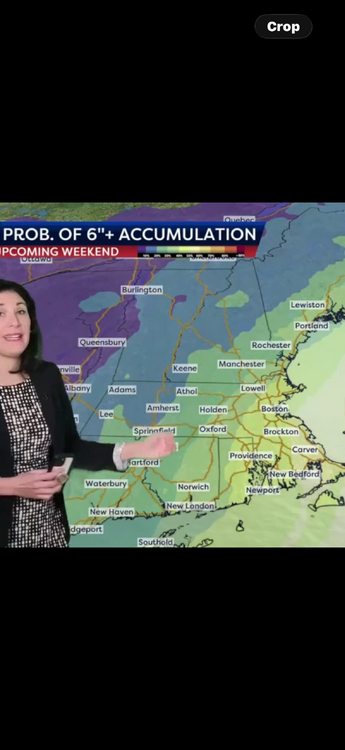
-
That AFD from Sterling was a mic drop. They said wait and see and don’t get married to any model run until tomorrow. Hard to argue that one.
-

The “I bring the mojo” Jan 30-Feb 1 potential winter storm
Shad replied to lilj4425's topic in Southeastern States
Cant say the NAM at 84 was awful....on to the Icon to take us out to sea -

Richmond Metro/Hampton Roads Area Discussion
wasnow215 replied to RIC Airport's topic in Mid Atlantic
I'll share on here and you will look lol JK -
Richmond Metro/Hampton Roads Area Discussion
wasnow215 replied to RIC Airport's topic in Mid Atlantic
I could see where if somebody gets .2 inches of precipitation it will equate to 4 inches of snow with this system. -
18z NAM looks kinda blah at the end. Flat with the vort at 84 vs it wrapping up on the 12z gfs at 90. Probably wasn't going to get much done here.
-
Discussion The ongoing settling of cold surface high pressure and additional surges in the wake of the historic winter storm will maintain dangerously cold temperatures for the central and eastern U.S. well into next week as per the Climate Prediction Center. The airmass may be more prolonged in areas with widespread snow/ice coverage and enhanced radiational cooling. Amplified mean troughing aloft will meanwhile bring rounds of weak to moderate clipper system snows from the north-central U.S. to the Great Lakes. In this anomalously cold pattern, there is potential for wintry precipitation into the Gulf Coast states late week as upper trough translation leads into northern Gulf frontal wave genesis. Wave progression downstream and trough/closed low development aloft is now increasingly likely to set the environment to produce a significant Eastern Seaboard Coastal Winter storm expected to rapidly deepen while lifting over the western Atlantic off the Southeast Saturday and Mid-Atlantic/New England Sunday. Uncertainty has improved but remains with the exact track of the low which impacts the onshore wintry precipitation focus and footprint. However, the growing consensus at this time is for heavy snow potential from the eastern Carolinas/Mid-Atlantic through coastal southern New England. The forecast strength of the deep low suggests high winds/waves and coastal flooding would also be expected.
-
Although most have missed out snow wise so far (at least to have more than a trace-dusting), this is very quickly turning into a winter to remember. If we get another solid run in February, it'll at least be the most exciting winter for the past several years in the SE.
-
Discussion The ongoing settling of cold surface high pressure and additional surges in the wake of the historic winter storm will maintain dangerously cold temperatures for the central and eastern U.S. well into next week as per the Climate Prediction Center. The airmass may be more prolonged in areas with widespread snow/ice coverage and enhanced radiational cooling. Amplified mean troughing aloft will meanwhile bring rounds of weak to moderate clipper system snows from the north-central U.S. to the Great Lakes. In this anomalously cold pattern, there is potential for wintry precipitation into the Gulf Coast states late week as upper trough translation leads into northern Gulf frontal wave genesis. Wave progression downstream and trough/closed low development aloft is now increasingly likely to set the environment to produce a significant Eastern Seaboard Coastal Winter storm expected to rapidly deepen while lifting over the western Atlantic off the Southeast Saturday and Mid-Atlantic/New England Sunday. Uncertainty has improved but remains with the exact track of the low which impacts the onshore wintry precipitation focus and footprint. However, the growing consensus at this time is for heavy snow potential from the eastern Carolinas/Mid-Atlantic through coastal southern New England. The forecast strength of the deep low suggests high winds/waves and coastal flooding would also be expected.
-
part of afternoon AFD from Sterling - still keeping everything on the table while pointing out the 12Z shift in most (non-GFS) models towards an OTS solution: KEY MESSAGE 3...Monitoring the potential for a coastal system this weekend. We continue to monitor the potential for snow associated with a coastal low this weekend. Nearly all model solutions show a strong coastal low forming, but there`s still considerable uncertainty regarding both where that low will track, and what impacts we will experience locally. Potential outcomes range anywhere from a storm that tracks well out to sea with little impact locally, to a storm that tracks closer to the coast and produces heavy snowfall across the region. The general flow pattern forecast by models has many of the synoptic features associated with Mid-Atlantic snowstorms, with ridging along the West Coast, troughing along the East Coast, ample cold air in place at the surface, and then downstream blocking over the North Atlantic. However, the trend with incoming EPS and GEPS trended significantly downward with probabilities for snow, ultimately showing a further southeast and out to sea track. The 12z GFS shows the potential snowier solution, and GEFS probabilities for snow trended upward. Spatially speaking, probabilities are highest for snow in all guidance the further southeast you go. In our area, southern Maryland would have the greatest chance at seeing snow. It`s worth noting that the flow pattern at upper levels preceding this storm is highly complex. The primary disturbance that will ultimately contribute to the development of the system is actually located over Newfoundland currently and will rotate westward around an upper low centered over Hudson Bay, before turning southward and digging out the trough that will eventually provide the forcing for the development of the coastal low. As this disturbance turns southward, it will also be influenced by an upper low over Alaska and a building ridge over the West Coast. Given the high complexity of these interactions, it may take another 1-2 days for models to settle into a higher confidence solution, and as a result, the door is still open for large forecast shifts.
-

The “I bring the mojo” Jan 30-Feb 1 potential winter storm
ecrugger replied to lilj4425's topic in Southeastern States
This storm may be the end of me. I'm in Hampton Roads. Supposed to go to Texas to visit my oldest daughter on Friday. But I'm concerned about leaving my wife and three other kids at home and really concerned about how I will get back here on Sunday. -
I think Gemini is reading my mind lol


