All Activity
- Past hour
-
One of the best storms/legit blizzards of my lifetime was Feb 9-10 2010.. a Miller B.
-
Need to kick that Bering Sea trough west
-

Boxing Night Snow/Sleet/Ice Dec 26-27 Storm Thread/Obs.
Birds~69 replied to Mikeymac5306's topic in Philadelphia Region
Model-schmodel....just wing it and real time it at this point. 27F, cold air holding firm... -
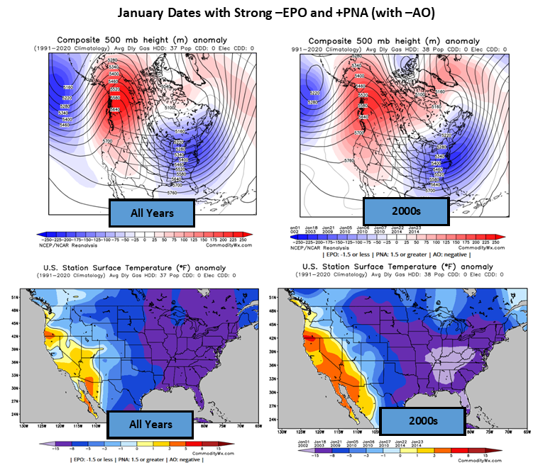
Commodity Wx Group @commoditywx Euro weeklies have strong -EPO and +PNA with -AO conditions by 3rd week of January, which would favor another big cold outbreak (1/23 EIA week).
-

Central PA Winter 25/26 Discussion and Obs
Ruin replied to MAG5035's topic in Upstate New York/Pennsylvania
lol I guess you didnt see what ive said radar is very dry and temps are all rdy higher then forecasted. 29 was the high last night for today now its been revised up to 33. all rdy 31.7 -

26th-27th event, coming at us like a wounded duck.
SouthCoastMA replied to Go Kart Mozart's topic in New England
-

26th-27th event, coming at us like a wounded duck.
Fozz replied to Go Kart Mozart's topic in New England
Actually we don’t know what the snowfall amounts will be. I don’t know if ORH is getting 1” or 6”. -
In Harford county today and there was a little freezing rain. Deck a bit slick.
-

26th-27th event, coming at us like a wounded duck.
Baroclinic Zone replied to Go Kart Mozart's topic in New England
Probably got just around 1” in that. -
Of course you would.
-
NWS has upped our (Selden, NY) totals tonight from 5-9 inches up to 6-10 inches.
-
26th-27th event, coming at us like a wounded duck.
SouthCoastMA replied to Go Kart Mozart's topic in New England
To be fair he has less than me. 12/14 kinda porked his locale -

26th-27th event, coming at us like a wounded duck.
WinterWolf replied to Go Kart Mozart's topic in New England
So old it only shows half the region. -
Doubtful but I think if Boston gets 3”+ NYC gets less than 3. I don’t see this as a situation where both cities win. The snow really making it that far E means either/both a lot of warm mid level air or a dry slot under the warm advection heavy snow in NYC. NWS also quite aggressive out here, my point/click is 7-11” and expected amount up to 9”. I’m thinking the low end of that and any 9” would be out by Port Jeff to Riverhead maybe but we’ll have to see. Regardless 7” is still a very respectable event. Still thinking the city is a general 3-6”, 3 for Staten Island and Rockaways, 6 for the Bronx and NE Queens.
-
26th-27th event, coming at us like a wounded duck.
WinterWolf replied to Go Kart Mozart's topic in New England
The guy to your west in Taunton does. -

Central PA Winter 25/26 Discussion and Obs
Mount Joy Snowman replied to MAG5035's topic in Upstate New York/Pennsylvania
Sitting at 30/15 as light sleet has started to break out. -
Sometimes you are just plain strange. Who are the "most seasoned mets" you are referring to??? I have not seen any met saying to wait 3 more weeks before any chance of winter weather. What are you looking at that would lead you to believe that? Please post a link.
-
Good luck..2-5 is a better call
-
Going to be fun to start now casting this in about 4 hours. Really am interested to watch this unfold.
-
That's a good surge of moisture into WPA and WNY. I expect some really heavy snow this afternoon into the Catskills and ENY. On radar it definitely looks like the brunt of it is setting up to our north. Should get a good burst though this evening.
-

26th-27th event, coming at us like a wounded duck.
Damage In Tolland replied to Go Kart Mozart's topic in New England
Old skool Rap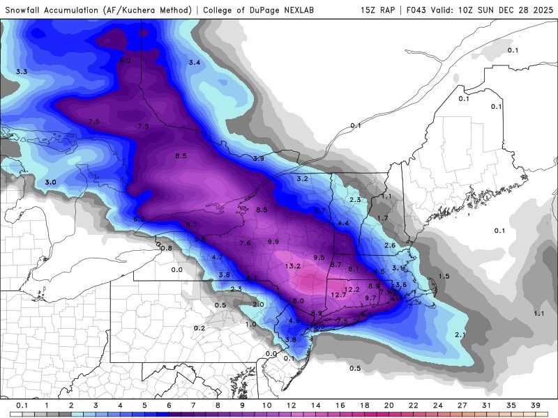
-

Central PA Winter 25/26 Discussion and Obs
mahantango#1 replied to MAG5035's topic in Upstate New York/Pennsylvania
Started sleeting about 10 min ago. -

Central PA Winter 25/26 Discussion and Obs
canderson replied to MAG5035's topic in Upstate New York/Pennsylvania
Sleeting at Wegmans. About to head home TV update: currently estimated delivery time: 2:42 pm -
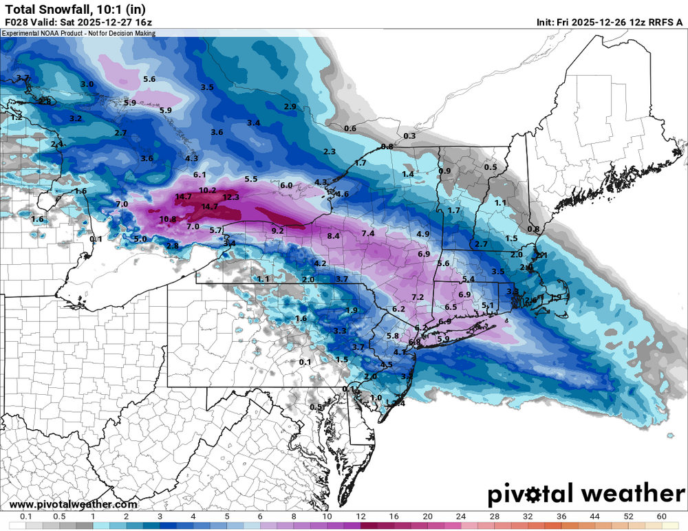
SIAP, but Mt. Holly updated their warnings for Somerset, Middlesex and Monmouth to 4-7" (they'd been saying 3-5" but noted 5-6" likely for northern sections of each county in their morning AFD and they still note the sharp south to north gradient due to sleet). And my hourly graphic snow went up from 5.7" to 6.1" which is exactly my prediction from yesterday, lol. The rest of the advisories and warnings were updated too, which includes Hunterdon/Mercer being upped from 2-4" of snow/sleet to 3-5" and the warnings for all of NENJ (Union to Bergen), NYC, SENY and most of LI were bumped up to 6-9".URGENT - WINTER WEATHER MESSAGE National Weather Service Mount Holly NJ 125 PM EST Fri Dec 26 2025 Somerset-Middlesex-Western Monmouth- Including the cities of Somerville, New Brunswick, and Freehold 125 PM EST Fri Dec 26 2025 ...WINTER STORM WARNING REMAINS IN EFFECT UNTIL 10 AM EST SATURDAY... WHAT...Heavy mixed precipitation expected. Total snow and sleet accumulations between 4 and 7 inches and ice accumulations around a light glaze. ADDITIONAL DETAILS...There will be a sharp gradient from south to north across the counties. Highest snow amounts will be in the northern half of the county as sleet mixes in from the south. Rates of up to 1 inch an hour will cause travel impacts Friday night.
-

Boxing Night Snow/Sleet/Ice Dec 26-27 Storm Thread/Obs.
RedSky replied to Mikeymac5306's topic in Philadelphia Region
Future NAM saves many Hrrr similar