All Activity
- Past hour
-
For East Tennessee Knoxville topped out at 33, and Chattanooga 34 on Sunday during the warm nose. If those numbers are just a little too warm and over modeled by a few degrees then talking about long duration ice with no thaw then temps quickly crash. This is what I think people really need to prepare for in the end just in case. How many times have we seen low level cold be under modeled and also more stubborn to warm up over the years. Sent from my Pixel 10 Pro XL using Tapatalk
-
Eyeballing those panels looks like about 11" here. 8" snow and 3" sleet then a .1 of ice. That is OK, minus that the OTG total after it stops will be in the 7" range. It'll be around a while though.
-

Central PA Winter 25/26 Discussion and Obs
Blizzard of 93 replied to MAG5035's topic in Upstate New York/Pennsylvania
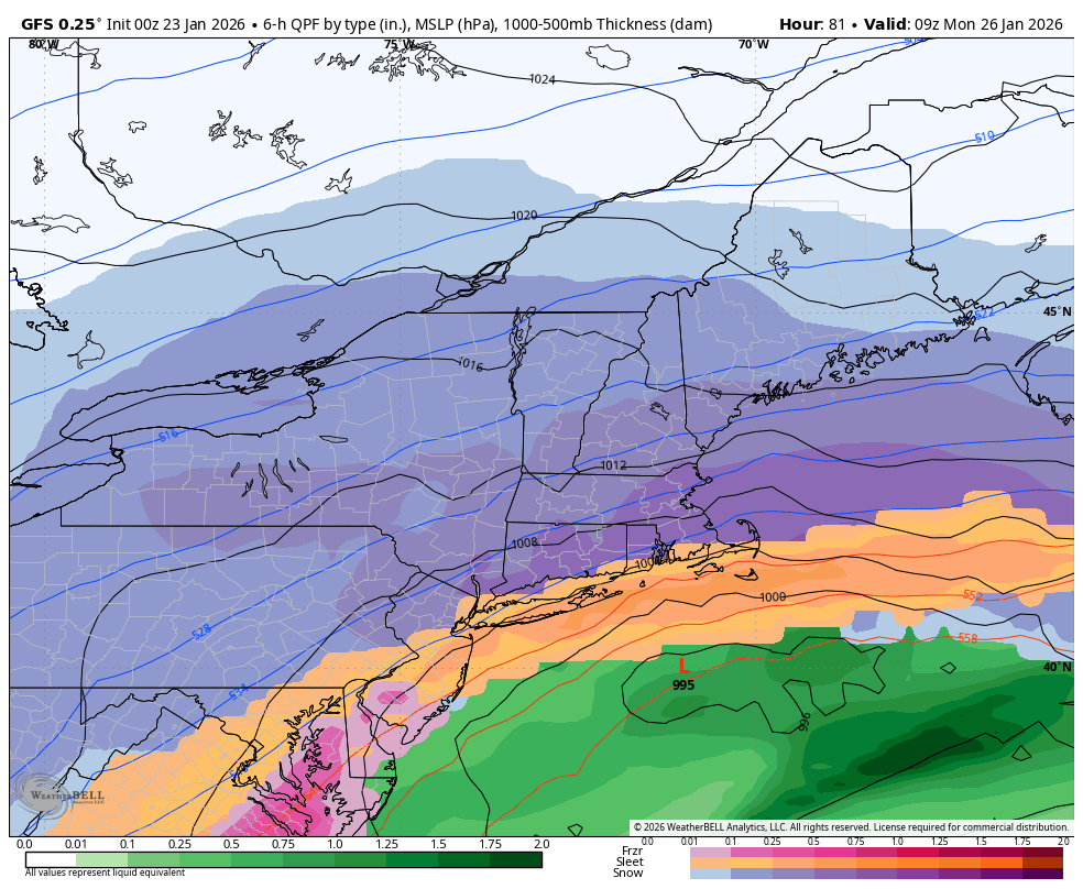
Still ongoing snow at hour 81
-
THIS. Even in Raleigh, temp drops from 34 back to the upper 20s before noon.
-

Central PA Winter 25/26 Discussion and Obs
WmsptWx replied to MAG5035's topic in Upstate New York/Pennsylvania
Altoona the big winner lol -
GFS is significantly colder at surface and 850 based on the maps; I've not looked at the numbers yet. There is certainly a period of some ice Sunday but that solution is very different from the NAM.
-
 we don't know what's going to happen, this could easily trend south or stay where it's at we don't know!
 -
.thumb.png.4150b06c63a21f61052e47a612bf1818.png)
“Cory’s in LA! Let’s MECS!” Jan. 24-26 Disco
HIPPYVALLEY replied to TheSnowman's topic in New England
This will be a much needed storm. regardless of meeting inflated max potentials -

Pittsburgh/Western PA WINTER ‘25/‘26
colonel717 replied to Burghblizz's topic in Upstate New York/Pennsylvania
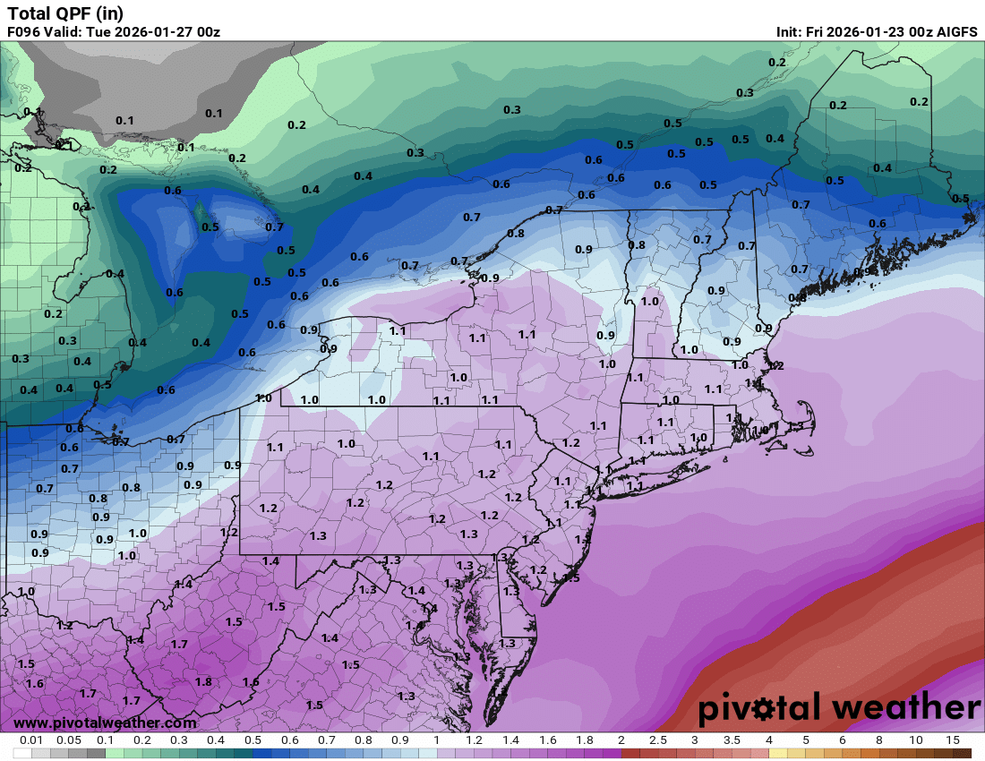
AIGFS no change
-

Central PA Winter 25/26 Discussion and Obs
MAG5035 replied to MAG5035's topic in Upstate New York/Pennsylvania
GFS did get a tad NW with the snow/sleet line compared to its 18z run, getting into a portion of Lancaster and maybe extreme southern York. Still a plenty big enough hit for everyone. Top end down a slight bit area-wide, basically 18-19” (Kuchera) for everyone. -

Central PA Winter 25/26 Discussion and Obs
Jns2183 replied to MAG5035's topic in Upstate New York/Pennsylvania
GFS had all 12 of new drops the hurricane hunters did today. The new Euro will as well Sent from my SM-S731U using Tapatalk -
 The models keep warming but the qpf keeps going up, totals don't really change.
 -

Central PA Winter 25/26 Discussion and Obs
paweather replied to MAG5035's topic in Upstate New York/Pennsylvania
Sure is… -

MO/KS/AR/OK 2025-2026 Winter Discussion
MUWX replied to stormdragonwx's topic in Central/Western States
It would really be something if the GFS pulls the upset here. It’s sure sticking to its southern idea. -
-
GFS Ice trend
-

Central PA Winter 25/26 Discussion and Obs
2001kx replied to MAG5035's topic in Upstate New York/Pennsylvania
from pitt forum -

Central PA Winter 25/26 Discussion and Obs
pasnownut replied to MAG5035's topic in Upstate New York/Pennsylvania
perty snowmaps slightly better for M/D line and north. small changes, but thats a win, cause there ar no BIG changes. -

January 24-26: Miracle or Mirage JV/Banter Thread!
Nomz replied to SnowenOutThere's topic in Mid Atlantic
Oh, I know I'll be better up there. Just very spiteful about it. Anyways, either GFS should be permanently ignored or it's about to go on the greatest model Linsanity run I've ever seen. -

January 24-26: Miracle or Mirage JV/Banter Thread!
nj2va replied to SnowenOutThere's topic in Mid Atlantic
I am looking forward to your obs Sunday morning that its a “BEATDOWN right now” out by you! -

Central PA Winter 25/26 Discussion and Obs
canderson replied to MAG5035's topic in Upstate New York/Pennsylvania
The GFS has been very consistent since it hooked onto the “two stage” setup two or so days ago. If it’s wrong, what a massive black eye for it on a season it has been quite poor. -
Stays below freezing for the entire event in Hickory, but swings from a “high” of 31 F at 4 AM on Monday morning to 17 F at 7 AM. That’s a crazy temperature swing over that period.
-

Possible Record Breaking Cold + Snow Sunday 1/25 - Tuesday 1/27
SACRUS replied to TriPol's topic in New York City Metro
1/23 0z GFS total QPF storm Total snow / sleet (10:1) -
It didn't really hold serve in my view, it may a significant overall shift to the others.
-
Ive lived here long enough to know CAD means rain here. Whatever frozen there is will rapidly go to 40 and rain