All Activity
- Past hour
-

September 2025 OBS-Discussion centered NYC subforum
MJO812 replied to wdrag's topic in New York City Metro
I was looking forward to alot of rain today. Another model bust. -

September 2025 OBS-Discussion centered NYC subforum
doncat replied to wdrag's topic in New York City Metro
Geez 0.12" here...maybe the southern extent near philly clips us. -

September 2025 OBS-Discussion centered NYC subforum
FPizz replied to wdrag's topic in New York City Metro
RGEM has sucked a lot the past year or so with precip -
.77 rain today, most rain I had since the last week of July. Got back from Louisville KY. on Monday night late from attended the largest 4 day rock festival in the country (Louder Than Life) It was very hot 3 out of the 4 days there with temps in the 90's.
-

September 2025 OBS-Discussion centered NYC subforum
Brian5671 replied to wdrag's topic in New York City Metro
Horrible performance by just about every model -
0.32” from this morning’s showers
-

September 2025 OBS-Discussion centered NYC subforum
forkyfork replied to wdrag's topic in New York City Metro
maybe the nw trend can help us with this next disturbance on the front -
Not liking the trends up here in the mountains. Still want to see a few more models runs before I start making any preparations or anything.
-
6z EURO is very wet Saturday afternoon into the overnight.
-
We hit 96 yesterday, with a real feel of 105! Thankfully a quick hitting TStorm hit us early this morning, dumping a quick .40" of MUCH needed rain. Hopefully we can squeeze some more precip from a TStorm or 2 later today.
-

September 2025 OBS-Discussion centered NYC subforum
Stormlover74 replied to wdrag's topic in New York City Metro
Once again models were mostly unreliable. Euro had an inch at ewr falling by 18z and they've barely crossed .1 Rgem way overdone. Nam sucked per usual -
Just got a nice burst under that red just north of Baltimore City... picked up .27 for the day so far and .50 for the event.
-
SC, you in danger girl. Give me the remnants and deluge.
-

September 2025 OBS-Discussion centered NYC subforum
SnowDemon replied to wdrag's topic in New York City Metro
It's humid but the breeze still feels somewhat raw. -
I picked up almost one half inch between midnight at 6:30 AM. That was after another 0.2 between 6-9 PM. Rainfall is also on our doorstep again this morning. This is all very welcome.
-
PRE is Predecessor Rainfall Event. Essentially a rain event that is ahead of the main event. Sandy in 2012 had that on the Eastern Shore. The PRE for Helene is what did the Appalachian Mts. dirty. Source: https://site.extension.uga.edu/climate/2020/10/what-is-a-predecessor-rain-event-pre/
-
 The interaction of the two storms and the ULL could lead to some nasty flooding. I don't like that models are starting to pick up on a stalled moisture feed
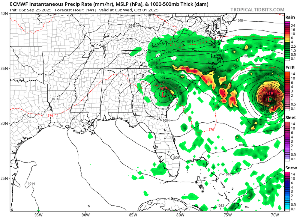
-

2025-2026 ENSO
40/70 Benchmark replied to 40/70 Benchmark's topic in Weather Forecasting and Discussion
I'll go out on a limb and say we won't be stuck in +EPO patterns for the majority of winter 2025-2026. -

September 2025 OBS-Discussion centered NYC subforum
Rmine1 replied to wdrag's topic in New York City Metro
At least there’s a nice breeze to go along with the low DPs. -
No talk about this storm ?
.thumb.png.d677338a51175c9a277aeca5cdc1cdd6.png)
-

Fall 2025 Medium/Long Range Discussion
roardog replied to Chicago Storm's topic in Lakes/Ohio Valley
If we’re going to have nice “warm” days it might as well be October(especially early October). A cold and wet October isn’t exciting to me anyway unless you’re just looking for the first flakes of snow. November on the other hand is when we need a more active pattern for severe and or winter weather. -

E PA/NJ/DE Autumn 2025 Obs/Discussion
JTA66 replied to PhiEaglesfan712's topic in Philadelphia Region
Obviously too early to say if we'll be affected by the tropics in any way, but at least it's the first thing to track since last winter. 73F/DP 72F...disgusting! -
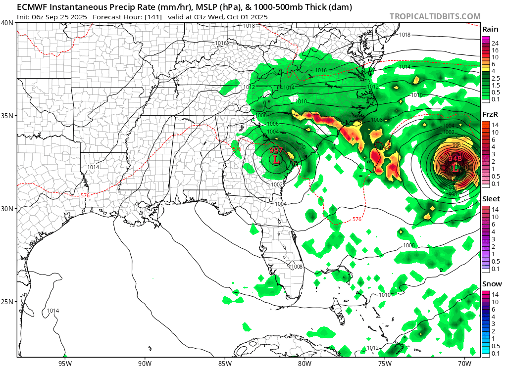
Pourin like the old man is snorin here right now
-
.thumb.png.1036e919bef6f8aa1641b2a49409bd8e.png)
-
Invest 94L—70% 2 day and 90% seven day odds of development
MJO812 replied to WxWatcher007's topic in Tropical Headquarters
.thumb.png.4488af623904fcad048ca4a7700ef10f.png)


.png.a4d06b2561cad5b56afacef765c126d9.png)

.png.8bf6558bc5eafa695a443fdbdb2e41d0.png)
.png.b9a5f13df8fef7662ffac239f985fc0f.png)