All Activity
- Past hour
-
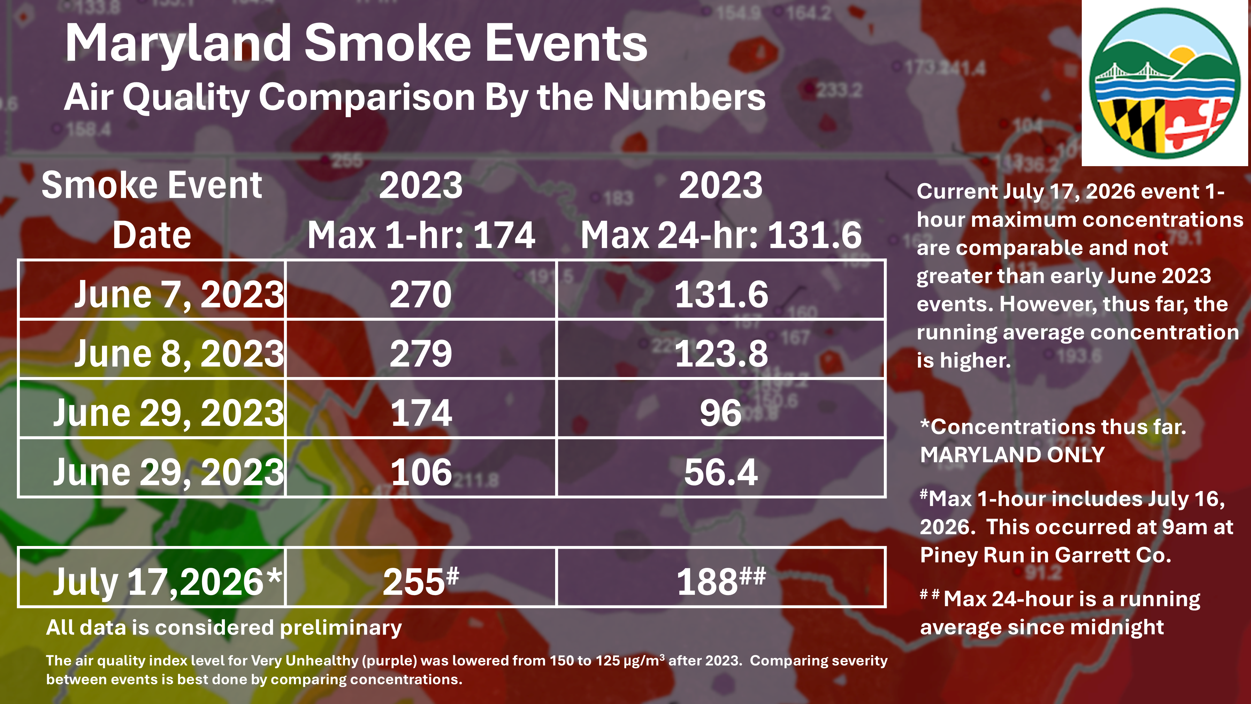
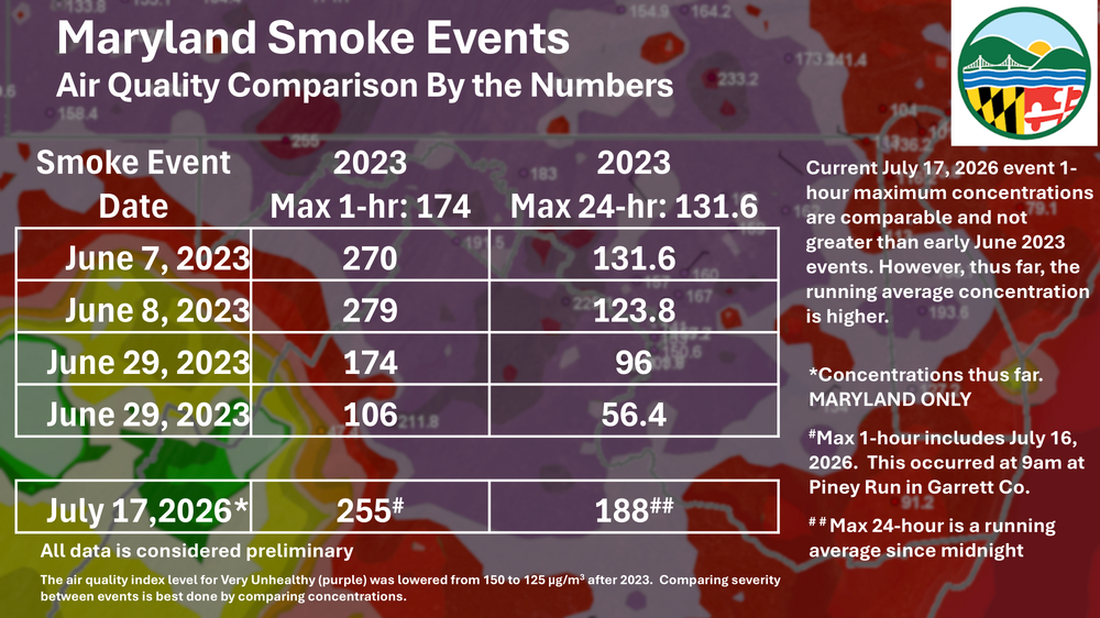
AQI at 371 and visibility at 1 1/4SM as of Noon. May very well be dealing with smoke and low visibilities the entire day today, especially with storms coming later that day. Certainly some June 2023 vibes going on.
-

2026 Mid-Atlantic Severe Storm General Discussion
Eskimo Joe replied to Kmlwx's topic in Mid Atlantic
Code Purple Rain to wash the smoke away.- 1,027 replies
-
- 1
-

-
- severe
- thunderstorms
- (and 7 more)
-
Cool site to track metar visibility. https://cyclonicwx.com/models/metar/neus/vis/
-
Heavily depends on the fit. If you have any kind of beard or even stubble the efficiency goes way, way down for pm 2.5. Unfortunately learned that half way through a diy brick repointing project
-
Spreading the word from our friends over at MDE.
-

Spring 2026 Pattern Discussion Thread
Carvers Gap replied to Carvers Gap's topic in Tennessee Valley
The "worst" of summer was partially in April! We had all of those highs in the mid and upper 80s. Since then, we have returned to VERY HIGH humidities to accompany relatively normal summer temps. When I go running in the mornings, it is like someone dumped a bucket of water over me by the time I am done. Still working on my winter ideas. This winter is a lean warm, but truly a crap shoot. I tend to think we start slow w/ kind of a meh December with gradually increasing chances. Late Jan to mid Feb seems like the sweet spot regardless of ENSO. I see no real change to that this winter. Somebody from the Plateau eastward could get hammered by an Apps runner or coastal this winter. As for fall, that season just seems hot lately. I do think Nino should temper the excessive heat and maybe bring normal fall temps by late September. Sometimes Nino winters kind of have a false start during October. The heat out West seems to suggest the Nino pattern has begun. Might be a good year for NE ski resorts? -
Smoke definitely waning a bit. I can see two blocks over now!
-
yeah DC is back in the Red
-
Good report on the wildfires. https://youtu.be/E7ncJlSaVCU?si=JLeSRwCxC1fk1lIe
-
Zero metering PM 2.5.
-
Not even noon yet, and it's already 97. Today gonna be bad
-
Yeah, it is bad, but it is not as awful as 7-8am. I'm down to 191. Hopefully any additional pulses won't equal this morning's mess.
-
Those mini rounds 14-16z on the HRRR/RRFS could be disruptive to the 18z one if they happen. Ideally you'd want that one to not happen so you don't have clouds in place or too much stability
-

2026-2027 Super El Nino
GaWx replied to Stormchaserchuck1's topic in Weather Forecasting and Discussion
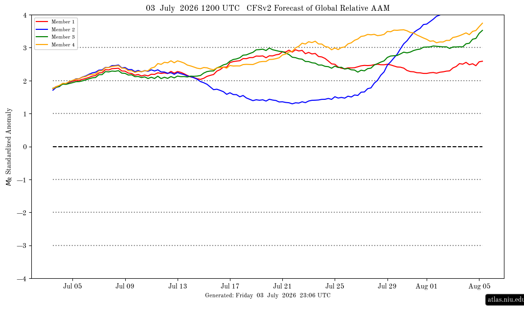
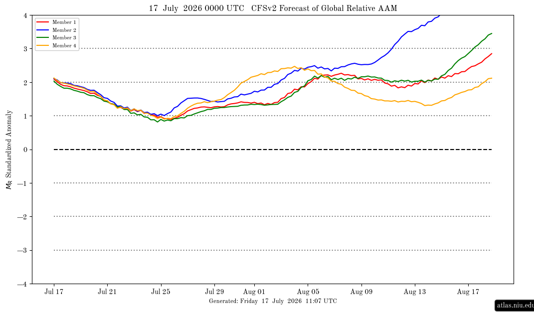
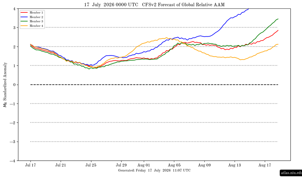
The CFS AAM at this site FINALLY updated for the 1st time in 2 weeks! Prior run from July 3rd: New one from today: +2 now but progged on 7/25 to drop to +1 vs the ~+2.2 mean on old run; progged mean doesn’t rise back to +2 til Aug 4th. Old run mean for Aug 4th was way up >+3. All of this is added evidence of a significant + bias out >2 weeks. Regardless, +AAM in full control, which is continued evidence of an intact steadily strengthening Nino: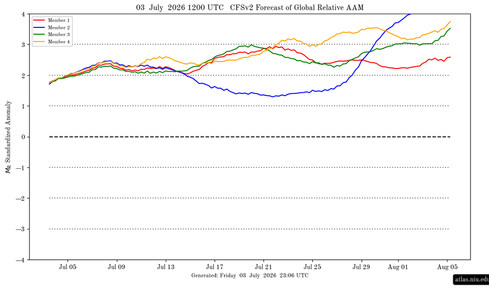
-
That’s expected improvement up there but, it’s not going to leave our area till Saturday morning.
-
It'll be interesting to see if HRRR and NAM3km are correct about our area getting hit hard during the morning. I would think afternoon/evening is more likely, but we shall see.
-
I see HRRR and NAM3km actually have a morning round now too, hitting us very hard here around 10am. Then the afternoon round and another round later at night. Hard to believe we'll get hit by 3 rounds, but 2 rounds seems like a pretty good bet. We need more rain so I hope the models are right.
- Today
-
(002).thumb.png.6e3d9d46bca5fe41aab7a74871dd8af8.png)
Central PA Summer 2026 Discussion/Obs Thread
ChescoWx replied to Voyager's topic in Upstate New York/Pennsylvania
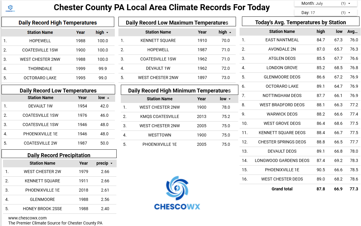
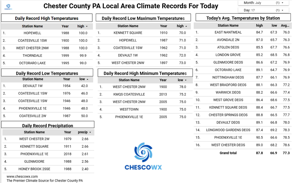
Smoke will continue to be a problem through tonight. We should be several degrees cooler than yesterday with what looks like to me no temps near 90 degrees for at least the next couple of weeks. Tomorrow will be warm and humid with showers and thunderstorms across the area. We turn much cooler by Sunday with highs in the upper 70's to near 80. Nighttime lows by Monday morning will be in the 50's across many of our lower valley locations. Temperatures through the next week look to remain below normal through what is on average our hottest week of the year.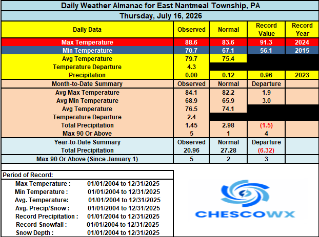
-
E PA/NJ/DE Summer 2026 Obs/Discussion
ChescoWx replied to PhiEaglesfan712's topic in Philadelphia Region
Smoke will continue to be a problem through tonight. We should be several degrees cooler than yesterday with what looks like to me no temps near 90 degrees for at least the next couple of weeks. Tomorrow will be warm and humid with showers and thunderstorms across the area. We turn much cooler by Sunday with highs in the upper 70's to near 80. Nighttime lows by Monday morning will be in the 50's across many of our lower valley locations. Temperatures through the next week look to remain below normal through what is on average our hottest week of the year.
-
Looks like we get another round later today in the afternoon from our NW.
-
It does seem to be improving modestly, particularly to our NE. DCA vis back up to 2.5mi - PHL is 6mi and the NYC area is no longer reporting "smoke".
-
Found a link with visible band optical depth. UMBC at ~2.5 and the Maryland science center at ~3. Those are pretty ridiculous.
-

2026 Atlantic Hurricane Season
WxWatcher007 replied to Stormchaserchuck1's topic in Tropical Headquarters
Yeah time is probably going to be one of the biggest factors here. If it can remain over the Gulf and head west, rather than getting caught up quickly and turned into FL, it should have a window for genesis. -
 28 @ the fake hollow in CT (probably)
 -
N95 should help, yes.