All Activity
- Past hour
-
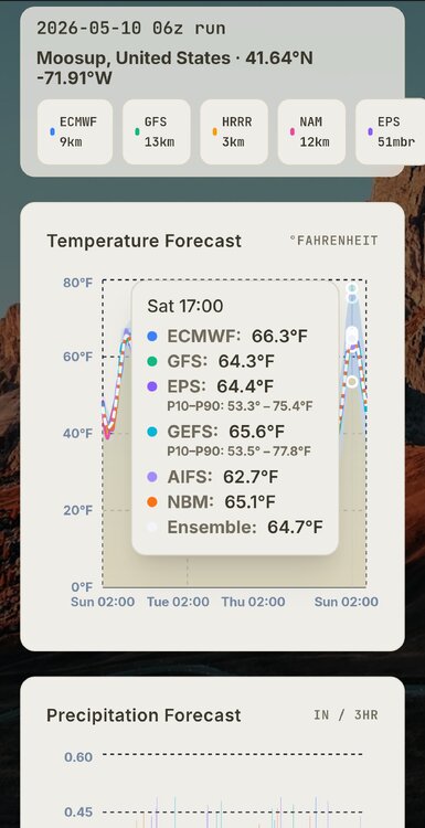
The NAM on Wednesday afternoon is interesting…… .
-
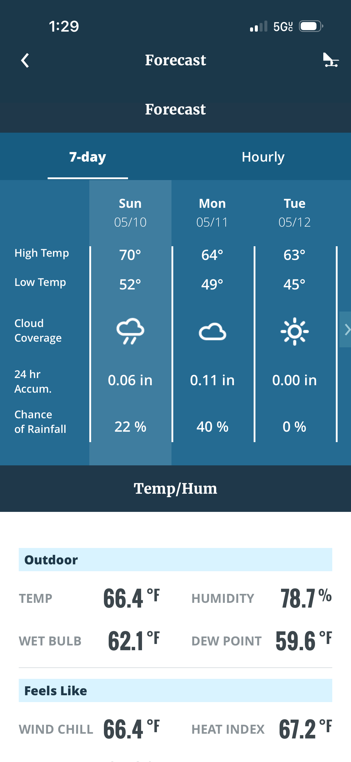
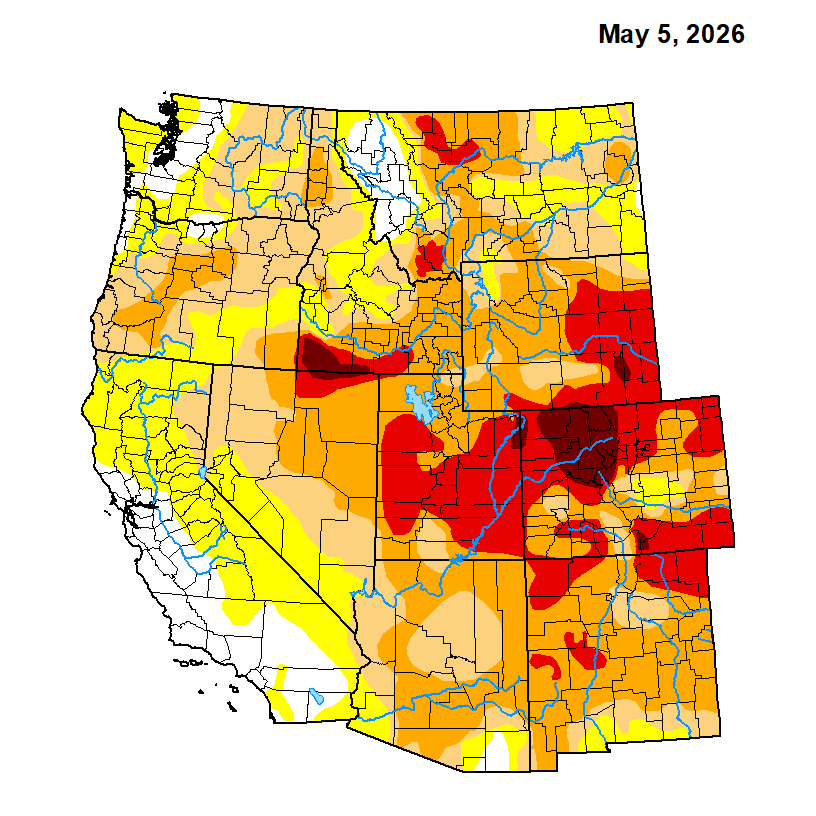
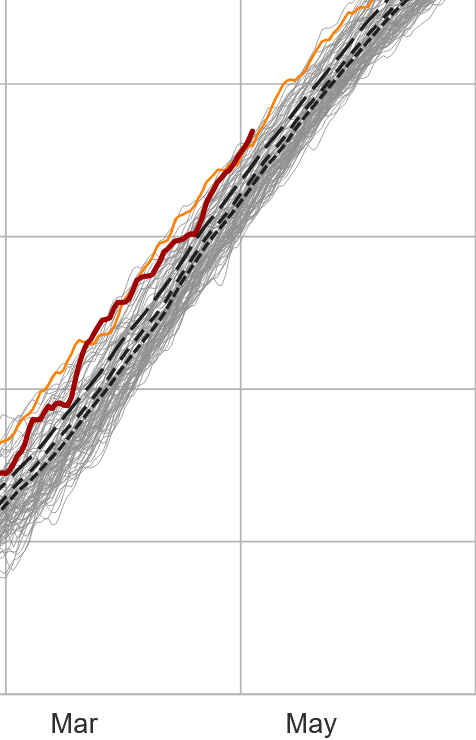
30-yr average at DCA is 10.65" for M-A-M. Lowest recently was 6.49" in 2023. 1986 is the modern times dud at 3.47". Most of the region is in the 4-7" range since March 1st, but DC to Annapolis and south are in worse shape. DCA is sitting at 3.72" and there are even spots in Calvert County and across the Bay that are ~2". There has not been a sub-6" Spring since 2006, so we are in rare territory if we don't get some substantial rain in the next 3 weeks.
-
Clouds look impressive to my west im sure the mountains will eat up most of the moisture
-
-
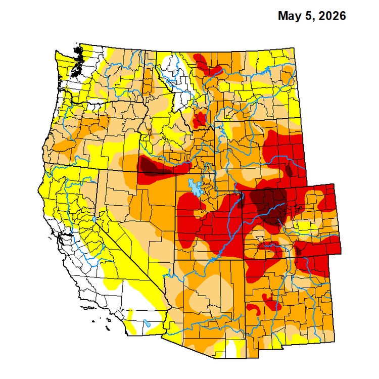
For NC piedmont and foothills it’s a matter of when not if we slip into exceptional drought. Long range looks dry and hot and obviously we missed most of the rain from last couple weeks.
-
Thursdays drought monitor will be interesting. I’d expect some marginal improvement along and south of I-85 but I’d say the foothills to the piedmont and southern VA are all about to be in an exceptional drought.
-

2026-2027 Strong/Super El Nino
jaxjagman replied to Stormchaserchuck1's topic in Weather Forecasting and Discussion
These westerlies the models have been showing has been countered with strong easterlies,so they have failed to get much past the IDL,maybe its gonna be different this time,probably could be the strongest ERW east of the IDL yet in this event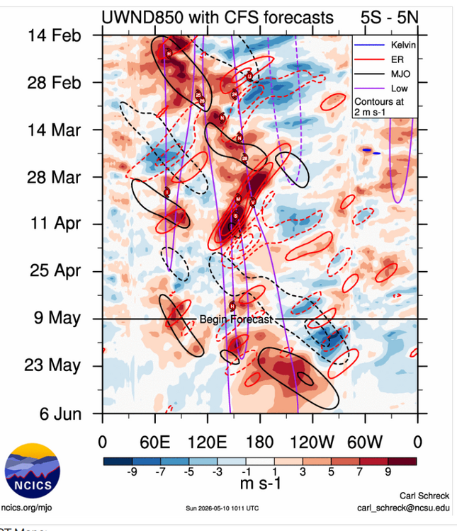
-

2026 Mid-Atlantic Severe Storm General Discussion
SnowenOutThere replied to Kmlwx's topic in Mid Atlantic
Thanks for the confirmation, I’m just spitballing in these threads after seeing the mesoanalysis page so it’s nice to hear I’m on the right track. Quick question but what is downdraft cape in relation to cape itself? Seems a bit like an oxymoron from the name itself. -
For the time being, and relative to date, the NH T mean has risen warmest comparing other curves in dataset for this product, https://climatereanalyzer.org/clim/t2_daily/?dm_id=nh
-
Multiple rumbles. Looks like we’re going to get 7-10’d.
- Today
-
-
Hot and dry. That’s how long range looks
-
2026-2027 Strong/Super El Nino
jaxjagman replied to Stormchaserchuck1's topic in Weather Forecasting and Discussion
Still seems kinda strange why you dont see the AAM and SOI synced up.Im not saying this wont be a strong NINO,even CPC today shows some pockets today of +8 down into the subsurface.The next WWB seems to be caused by a ERW into the eastern PAC,whicH we havent seen these strong WWB so far -
-
Its par for the course hear near RDU. Everything like to miss this small area for some reason. I'm glad we got the rain, although .52 for the event but areas about 15 mins NW got over an inch. Sitting a paltry .55 MTD
-

2026 Mid-Atlantic Severe Storm General Discussion
high risk replied to Kmlwx's topic in Mid Atlantic
You are correct that better moisture today would have contributed to a likely good event. That said, the deep dry boundary layer has a lot of downdraft cape, and there is definitely at least some potential for wind.- 326 replies
-
- 3
-

-

-
- severe
- thunderstorms
- (and 7 more)
-
Muggy? DP low to mid 50s
-

2026-2027 Strong/Super El Nino
snowman19 replied to Stormchaserchuck1's topic in Weather Forecasting and Discussion
I completely, totally disagree. This Nino is already extremely well coupled and looks nothing at all like a La Niña -
Good call in a sense... MRGL risk added for parts of the area
- 326 replies
-
- 1
-
-
- severe
- thunderstorms
- (and 7 more)
-
2026-2027 Strong/Super El Nino
jaxjagman replied to Stormchaserchuck1's topic in Weather Forecasting and Discussion
We seem to headed towards a WQBO into summer,while the AAM and even SOI is still not coupled quite well,they both look NINA and not NINO ATM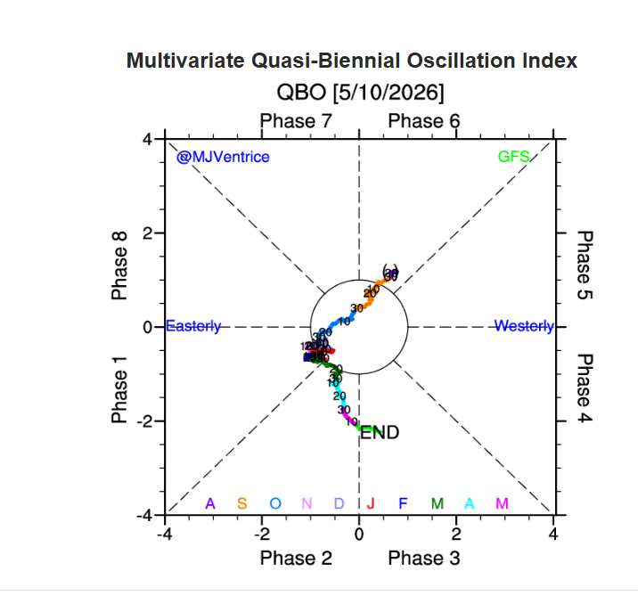
-
The drought angle has become a racket IMHO. It allows $$ to flow/be available b/c there is an "emergency" which open things up to graft/corruption. Having problems, real or invented, are profitable, and that one reason why we have so much hype and nonsense. The word "drought" in itself has become a pejorative more than it should. It's a somewhat similar word "climate." Hear that word and ppl freak or think "bad. "Drought" which has some bad by definition, but "climate" is a neutral word in this sense, but the media and politicians have turned into into a fear-instilling word. Look at this nonsense in Washington state. This blog entry lays out all the facts about how it is definitely *not* drought emergency status. Yet the the powers that be declare one, and their reason is b/c snowpack is only 50% of normal Yet all other factors that go into drought states indicate no issues at all. https://cliffmass.blogspot.com/2026/05/the-is-no-drought-emergency-in.html And the U.S. Drought Monitor, which factors in everything (there are 4 types of drought), not even half the state is actually in a drought, and it is only largely moderate status. It like so much these days, throttled to the max. Use the most superlative wording by default. No scaling or perspective. It's not an "alert," it is an "emergency" by default. There are no severe, heavy, or disastrous/disasters event/damage, it's all "catastrophic."
-

2026-2027 Strong/Super El Nino
GaWx replied to Stormchaserchuck1's topic in Weather Forecasting and Discussion
Here’s the RONI plumes that Ben tweeted that @snowman19just posted: https://twitter.com/BenNollWeather/status/2053479903761498266/photo/1 -4 of these 10 would be a new record RONI (goes back to 1950): CMCC, BoM, JMA, NCEP (CFSv2 keeps rising and is now +2.7 for seasonal peak as Prof. Eliot just tweeted). -Euro is close to a 1982-3 redux -OTOH, the UKMET, which has performed as one of the better models over the years, doesn’t even reach +2.0 for RONI monthly and peaks at only +2.3 for ONI monthly. So, the UKMET still isn’t even close to the record +2.7 monthly/+2.5 seasonal record RONI peaks of 1982-3 even though it appears to be a couple of tenths warmer than its prior run. -So, whereas the majority of the better models suggest at least a 1982-3 redux is a good possibility, the UKMET is still ~0.7 cooler than 1982-3 on a RONI basis even with this slightly warmer run. That along with certain May model runs (like Euro longterm and BoM more recently) still being subject to notable warm bias are enough to still keep me wary of the admittedly rising possibility that 2026-7 will at least get close to 1982-3. The chance of a 1982-3 redux or even warmer is rising but is still very far from a slam dunk. OTOH, getting a RONI super-strong peak is now ~60% chance in my mind. I’d have it higher than 60% if the UKMET weren’t still not reaching super even for a single month. -
Sun finally breaking out. 63 and muggy