All Activity
- Past hour
-

December 2025 Short/Medium Range Forecast Thread
Carvers Gap replied to John1122's topic in Tennessee Valley
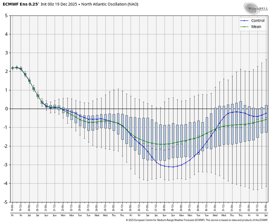
The para 0z GDPS is very cold on the 28th-29th before the run ends. I have a feeling (if the NAO strengthens and models aren't hurrying it up too much), that cutter may bring down more cold than models are depicting. If the NAO starts a bit slow, then the GFS will score that timeframe. -

December 2025 regional war/obs/disco thread
WinterWolf replied to Torch Tiger's topic in New England
You an TBlizz should hook up… -
55° at HIE and mostly low/mid 30s in C NH
-
Just looking at those pics it looks like nom stop blocked (neg NAO) vs. Central ridge.
-
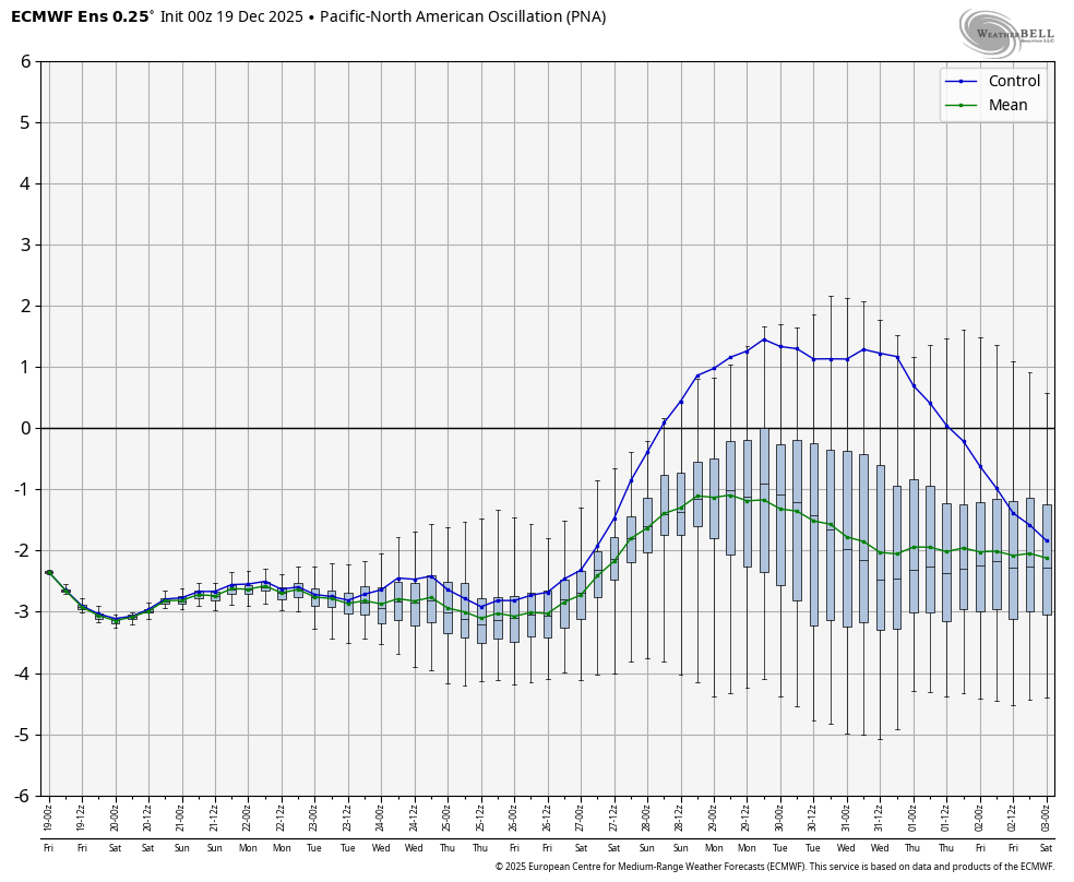
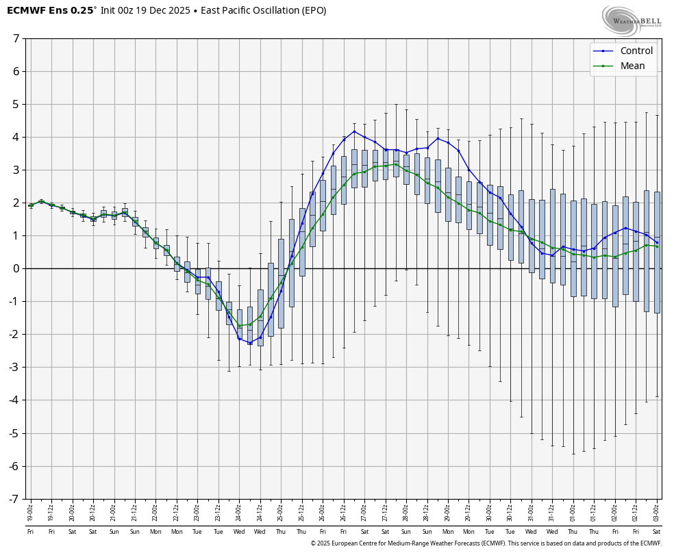
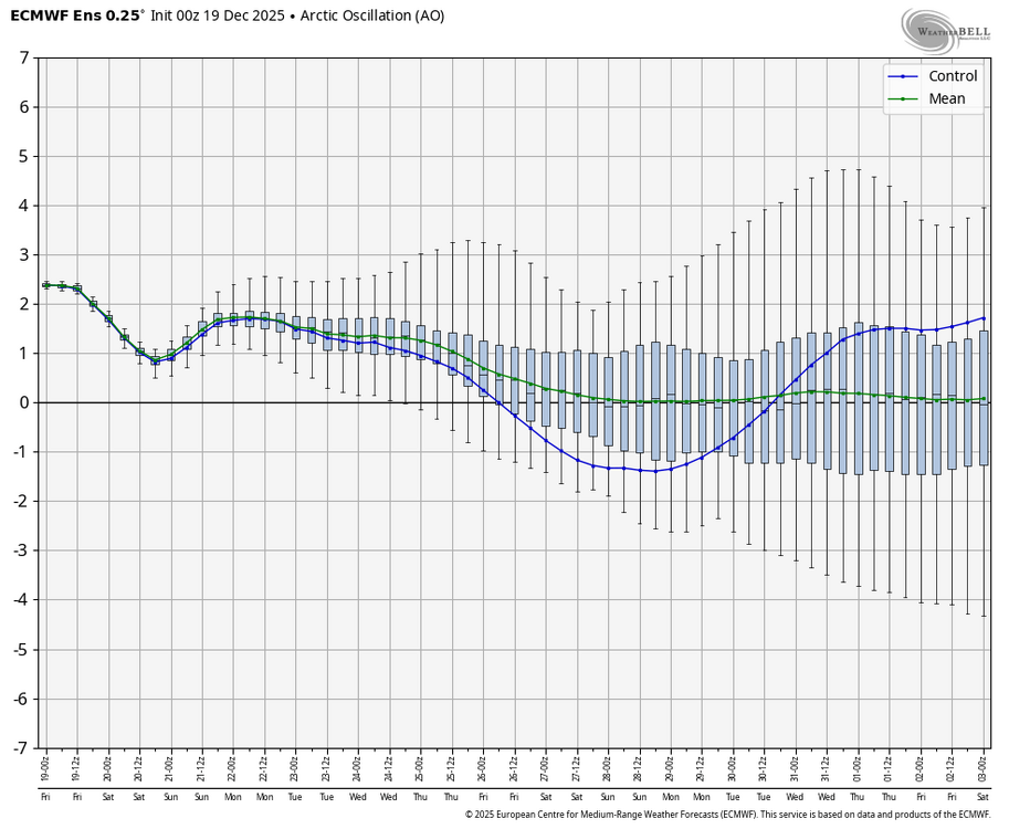
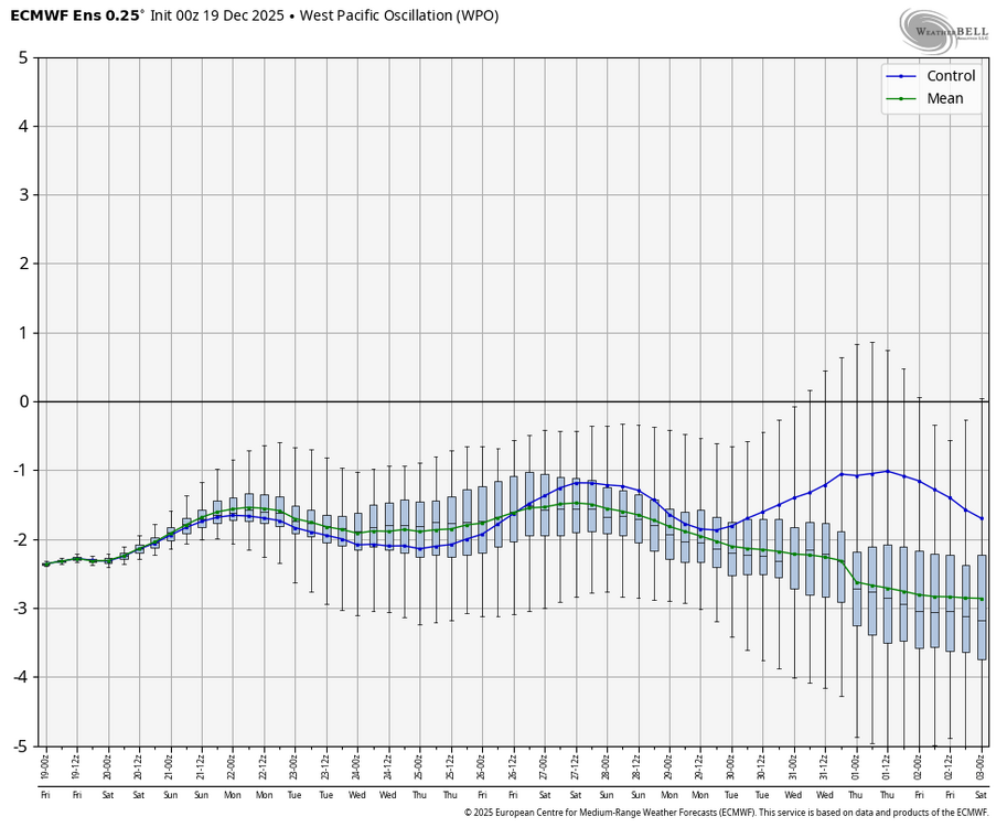
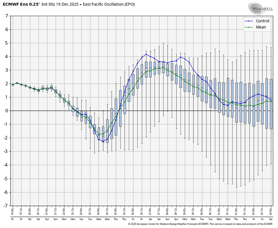
WB latest EPS on PNA. Anecdotally, when I see the PNA at -3 or lower, it just can't get cold enough at our latitude for snow....but notice it bumps up to near -1 around NY week and the control actually goes positive. At that point, a negative NAO could work some magic and pull some cold air fine with the AO neutral and the WPO negative. EPO is not favorable NY week.

-
December 2025 Short/Medium Range Forecast Thread
Carvers Gap replied to John1122's topic in Tennessee Valley
Line moved through here this morning. Wind and rain. Both the 0z CMC and Euro move plenty of cold air eastward beginning around the 29th. They could be too fast in breaking down the warm-up, but both have a cutter where the GFS does not. My guess would be the GFS is slightly too progressive, and misses it. If that cutter is legit, cold would roar down the Plains. Not sure how excited about cold on the 30th I am - Music City Bowl would be miserable! -
Regardless of what happens with this blocking potential. I think there's a pretty good chance of popping a +PNA after that first week of January. Via Pacific wave break. I can make a longer post about that tomorrow.
-

December 2025 regional war/obs/disco thread
Great Snow 1717 replied to Torch Tiger's topic in New England
The pattern isn't bad it is AWFUL... -
Still waiting for my damaging winds.
-
Its 6 fucking days before christmas. The next personal attacks are a ban, not just a month off. If you cant discuss the weather without being an asshole, try twitter.
-

December 2025 regional war/obs/disco thread
Damage In Tolland replied to Torch Tiger's topic in New England
Why would you post a valley location? -
Overperformer here. 1.2" Looks like it should be ending soon.
-

Winter 2025-26 Medium/Long Range Discussion
A-L-E-K replied to michsnowfreak's topic in Lakes/Ohio Valley
february will be rocking? -
-

E PA/NJ/DE Winter 2025-26 Obs/Discussion
BBasile replied to LVblizzard's topic in Philadelphia Region
That was an interesting drive into work. Sheets of rain and traffic lights being blown in 30 mph winds and poor drainage flooding. Felt a little tropical. Currently 58.2F, rainfall up to 0.86". -
AI models are colder beyond Xmas too. Hopefully they have a good idea.
-
Still cold and calm here, 38F
-
Stay safe.

-
December 2025 regional war/obs/disco thread
Damage In Tolland replied to Torch Tiger's topic in New England
Already roaring this morning. This is gonna be a special one around here today. -
.34” per mesonet near me. I thought it was supposed to be closer to an inch haha
-

December 2025 regional war/obs/disco thread
moneypitmike replied to Torch Tiger's topic in New England
I'll be in Maine for Christmas........don't steal the snow SNE! -

2025-2026 ENSO
donsutherland1 replied to 40/70 Benchmark's topic in Weather Forecasting and Discussion
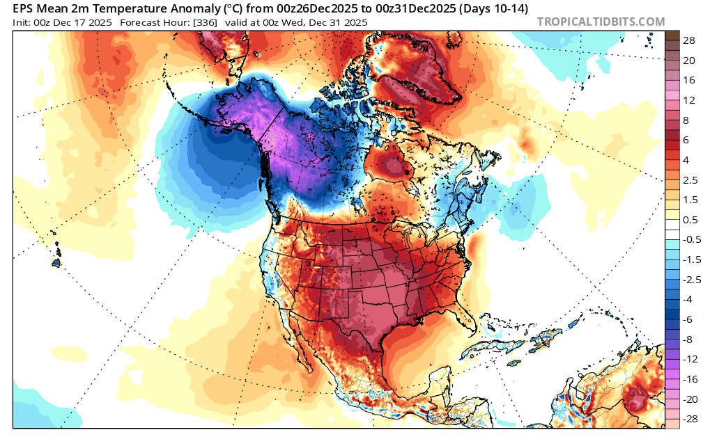
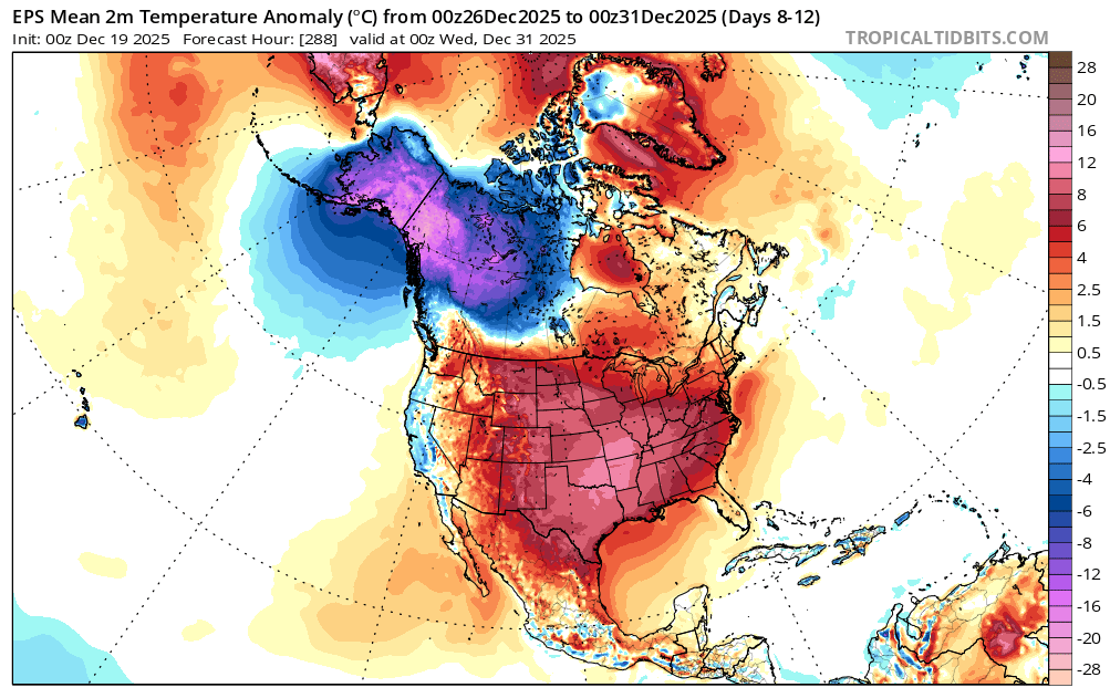
Just a brief note, the probability that the warmth will break through into the northern Mid-Atlantic and southern New England areas to close December has increased in recent days. The widespread warmth elsewhere in much of the CONUS and cold in NW Canada and Alaska remain intact. The forecast EPO+/PNA- seems sufficiently strong to offset the combination of a neutral AO and negative NAO even into parts of the Northeast now. Previously, the EPO was forecast to be mainly negative for the close of December. EPS from Wednesday 0z: EPS from Today 0z:

-
Seems like very little rain so far IMBY. 0.15”?
-
.thumb.jpg.6a4895b2a43f87359e4e7d04a6fa0d14.jpg)
Central PA Winter 25/26 Discussion and Obs
Yardstickgozinya replied to MAG5035's topic in Upstate New York/Pennsylvania
Ohh, snap, that's looking pretty gnarly again -

Central PA Winter 25/26 Discussion and Obs
mahantango#1 replied to MAG5035's topic in Upstate New York/Pennsylvania
The snow on the ground is gone except for the piles that I created.