All Activity
- Past hour
-
Yup. It’s coming . Perfect pattern and setup for hit this year . 1954
-
How much longer can this epic weather last? I haven't really noticed any signs of smoke down here in SoMD. 77F and clear down here.
-

TROPICAL WAVE LOCATED IN CHAD, AFRICA (NOT 96L)
WxWatcher007 replied to BarryStantonGBP's topic in Tropical Headquarters
At least right now the GFS, Euro, and second tier models are in agreement that this one develops within the next 6 days or so. With 96L out of the way and a cross-guidance signal for strong Atlantic ridging this does look like a candidate to at least get to the SW Atlantic. From there, who knows. There are almost always unmodeled troughs/weaknesses at this range that could easily kick it before getting close to the US. -
 August 1948 Newark Weather Day High (°F) Low (°F) Precip. (inches) Snow (inches) August 24 90 64 0.00 0.0 August 25 96 70 0.00 0.0 August 26 103 73 0.00 0.0 August 27 99 73 0.00 0.0 August 28 102 75 0.00 0.0 August 29 97 77 0.00 0.0 August 30 88 71 0.00 0.0 August 1948 New York City Weather Day High (°F) Low (°F) Precip. (inches) Snow (inches) August 24 84 69 0.00 0.0 August 25 95 72 0.00 0.0 August 26 103 78 0.00 0.0 August 27 101 79 0.00 0.0 August 28 100 78 0.00 0.0 August 29 95 78 0.00 0.0 August 30 87 73 0.00 0.0 August 1948 JFK Airport Weather Day High (°F) Low (°F) Precip. (inches) Snow (inches) August 25 94 71 0.00 0.0 August 26 100 76 0.00 0.0 August 27 101 76 0.00 0.0 August 28 98 77 0.00 0.0 August 29 96 78 0.00 0.0 August 30 90 72 0.00 0.0 August 31 83 63 0.00 0.0
 -

2025 Atlantic Hurricane Season
BarryStantonGBP replied to BarryStantonGBP's topic in Tropical Headquarters
-
Of course the one thing I root against will happen.

-
Isaias was a big hit, at least here. Joaquin is an all timer
-

Central & Eastern Pacific Thread
gallopinggertie replied to Windspeed's topic in Tropical Headquarters
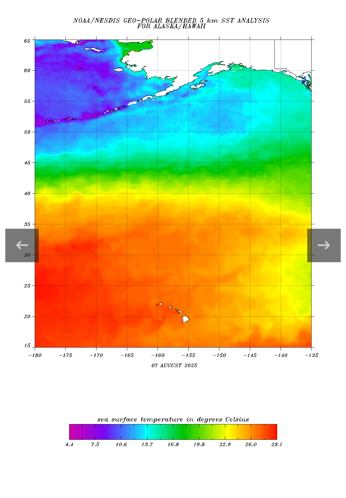
SST’s are way above average in the North Pacific. Actually, they’re warmer at the end point of that forecast cone than they are where Henriette is right now!
-
Just came back from kayaking on the local lake. Still some haze for sure.
-
9th warmest July on record for the Ohio Valley region, driven largely by West Virginia, which saw its hottest month on record. The State of Ohio recorded its 11th hottest July on record. Overnight low temperatures were especially impressive, as Ohio was one of 12 states to set a new record high for minimum temperatures in the month of July.
-
Couldnt have said it better myself. i know we are not alone in that either.
-

Occasional Thoughts on Climate Change
TheClimateChanger replied to donsutherland1's topic in Climate Change
-
Also hinting at a ridge over GL, but it would need to be a bit further south. With a -EPO and TPV in that position, there would be plenty of NS energy dropping southward. How far south and how it interacts with any potential southern stream waves might be interesting. Overall that depiction looks quite Nina-ish, but with the NE Pac ridge in a more favorable position/orientation for cold in the central and perhaps eastern US, especially NE.
-
79.3/63 The visibility is improved but there still seems to be some residual haze in the air and aloft.
-
"No injuries to wasps were committed in the making of this post"
-
Nice weather station, but most of all, I'm loving these deep blue skies !! No more air pollution !!
-
Just went out to refill the hummingbird feeder and the grape jelly and had a couple of yellow jackets and a bald faced hornet eating out of the jars. I waited until they were done and refilled. No injuries to humans or wasps to report.
-
If winds are SE take up the dews and lower the temps.. which is wanted quite honestly
-
Low frequency forcing/MJO 5-6-7 still in the same familiar area (around Maritime Continent) as we go further into this month. The Niña background state remains
-

TROPICAL WAVE LOCATED IN CHAD, AFRICA (NOT 96L)
GaWx replied to BarryStantonGBP's topic in Tropical Headquarters
The 12Z UKMET is likely the 1st with a TD from this as it forms in only 114 hours (thus lemon-worthy). After sliding just N of the N Leewards, it ends the run approaching TS strength (33 knts/38 mph winds) 430 miles ENE of PR moving WNW at a pretty brisk 18 mph. Will have to wait for maps to get better idea of whether or not its implying it would likely recurve offshore the Conus. NEW TROPICAL CYCLONE FORECAST TO DEVELOP AFTER 114 HOURS FORECAST POSITION AT T+114 : 15.8N 46.0W LEAD CENTRAL MAXIMUM WIND VERIFYING TIME TIME POSITION PRESSURE (MB) SPEED (KNOTS) -------------- ---- -------- ------------- ------------- 1200UTC 13.08.2025 120 16.1N 48.2W 1009 28 0000UTC 14.08.2025 132 17.8N 51.6W 1009 27 1200UTC 14.08.2025 144 18.9N 54.9W 1009 29 0000UTC 15.08.2025 156 20.3N 57.7W 1009 30 1200UTC 15.08.2025 168 21.4N 60.9W 1007 33 -
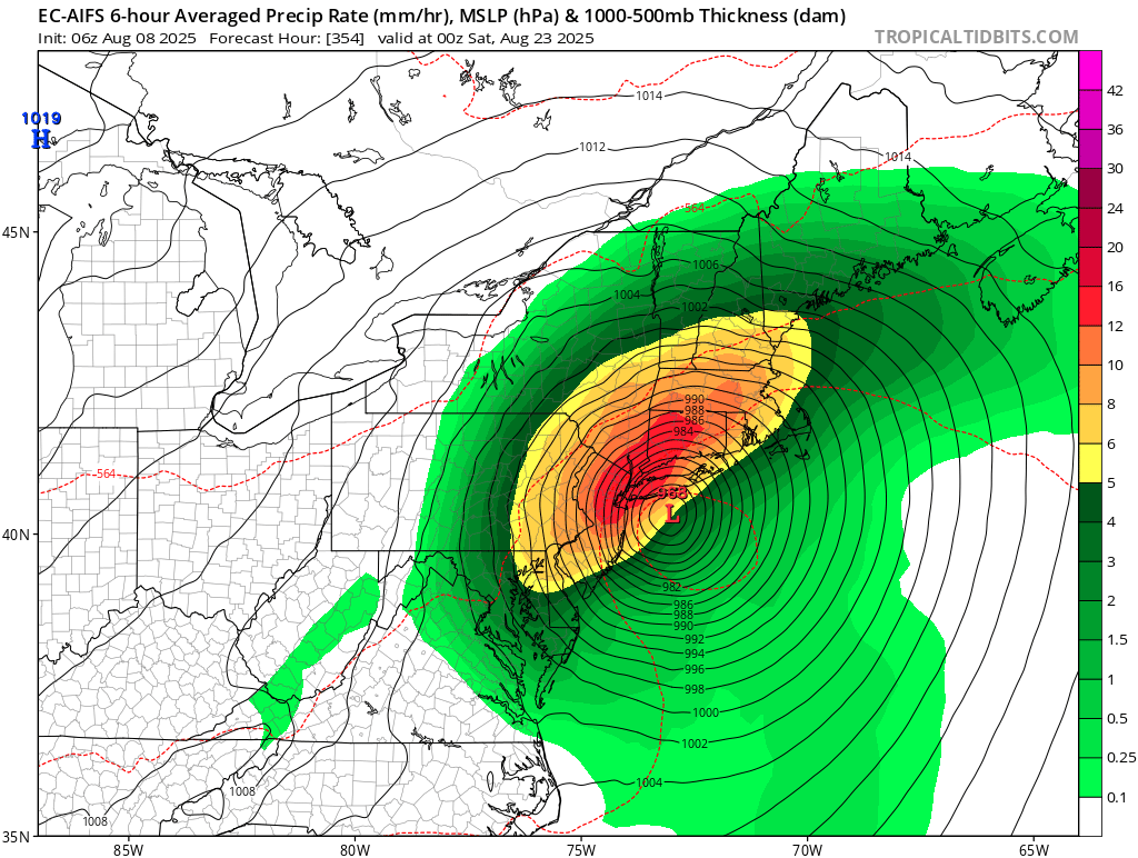
We are extremely overdue, not counting tropical storm meh-nri. Every season we have model runs showing impacts which almost inevitably whiff. I remember Erika, Lee, Isaias, even Joaquin being shown as threats that never ended up materializing. But the historical precedent is there for big hits as unlikely as they are, and the east coast is definitely more at risk this year than the past few gulf-heavy seasons.
-
i had a nest next to my garden last year and never got stung. they would land on me once in a while to check me out but if you're cool about it they don't bother you
-
I would have totally expected Virginia to be higher on the list if for no other reason than more area.
-
Wow. Sky seems much clearer here today than the last few days.
-
Occasional Thoughts on Climate Change
TheClimateChanger replied to donsutherland1's topic in Climate Change
Something to ponder that may go against the general narrative. Not only are the PRISM estimates routinely coming in higher, but nClimDiv continues to demonstrate a cooling bias relative to USCRN and it's really becoming rather significant in recent months. The July anomaly was +.21F higher for USCRN, which makes a big difference in the rankings when each hundredth of a degree matters.