All Activity
- Past hour
-
 Yeah 12z MET went big
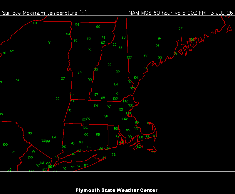
-
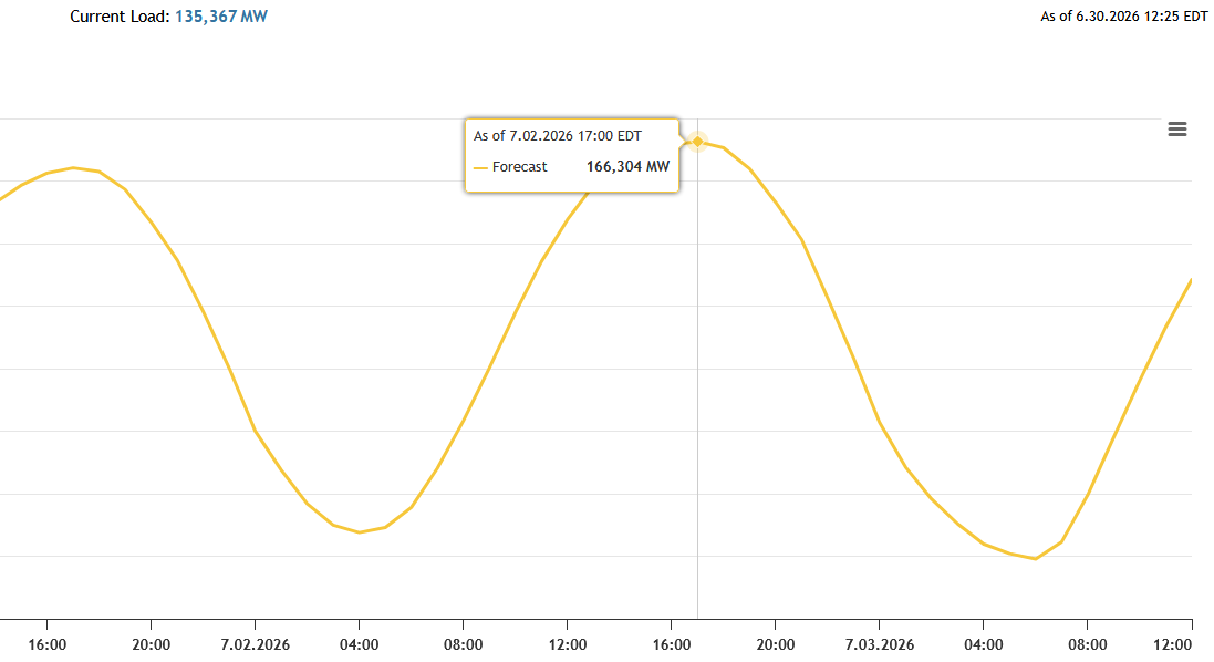
PJM is forecasting a record grid load on 7/2. Yesterday it was forecast to be 162, this morning they updated it to 166MW. The record I believe is 162 in 2006.

-
 The 12z NAM grid's fully on board. ..whether this shows up in the machine interpolations or not, notwithstanding... but this is about as hot as I've ever seen these numbers. BOS and LGA Thursday, left to right: 5400051 31 19 -1292 11 25 11 82 34 26 19 5400048 28 12 -3294 142310 82 34 26 20 6000054 39 34 -5891 10 24 16 83 34 27 18 6000047 32 20 -0993 132513 83 35 27 20 Left to right these number illustrate a pure sear scenario. Man and I mean it! 31 and 19% is bone dry sky. Open blue, 100% undiluted solar dump in. So is 39 and 34% at 00z Friday ( bottom row). That's BOS (Logan). Likewise, LGA (Laguardia) is no different. That's the sky coverage... The next digits moving right correspond to wind direction, and speed. 24 and 25 represent 240 and 250 deg, respectively, which average WSW, at 11 to 16 kts LGA, 280 and 320 is WNW, which is idealized actually ...and given to the fact that both locations are identical synoptic constraints, these are also mutable. Call it a west wind at both for now. 0 oceanic influence. The 82 and 83 corresponds to 582 and 583 hydrostatic heights ( referred to as 'thickness'). Anything over 572 is getting into a very warm column distinction. Obviously ... rising this number means integrating more and more water into the column and in order to do that, requires heat. So, clearing 580 is both exceptional rare around our latitude, but also rare for our geological limitations. I'm starting to feel this is our best synergistic heat performance we've seen since the phenom was recently codified. The rest of the numbers, "34 26 19" (BOS, left) is 18z, are deg C. 34 C, left, is at the 980 mb level. Which is very rare, because the actual 2 meter by convention is typically a minimum of 3C above this number in a well mixed adiabatic environment. 4 or even 5 C is not out of the question given to the fact that the total combination of synoptic parametrics are really quite spectacular when taken in holistically. So... in simple terms, a 38 or even 39 C over a the urban sprawl of metro-west of Boston towns is quite doable. Now ... the NAM is the NAM is the NAM... there's that. It also can sometimes go large in heat in the 48+ hour range...then settle back on newer runs. The other 12z guidance is probably rolling out now.
 -
89 right now matches yesterdays high
-

2026 Mid-Atlantic Severe Storm General Discussion
Eskimo Joe replied to Kmlwx's topic in Mid Atlantic
If we don't get some storms when this ridge breaks down a bit, then we're setting ourselves up for a very hot July. -
Nah. Just need 4-5 hours centered around peak insolation.
-
Yea, historically east-based events are very unfavorable for snow.
-

2026-2027 Super El Nino
Yanksfan replied to Stormchaserchuck1's topic in Weather Forecasting and Discussion
That’s what I’m banking on. As long as the ElNino from hell manages to slay the west pacific hot blob dragon, I’ll gladly sacrifice next winter to appease the weather gods. -
 That thunderstorm complex in Canada looks even better than it did this morning
 -

2026-2027 Super El Nino
PhiEaglesfan712 replied to Stormchaserchuck1's topic in Weather Forecasting and Discussion
1997 was close to neutral 2004 was close to neutral 2018 was a modest +QBO. I'll give him that one. That was a meh December (and winter overall), not an all out blow torch, like the other 5 +QBO/el nino Decembers. -
E PA/NJ/DE Summer 2026 Obs/Discussion
PhiEaglesfan712 replied to PhiEaglesfan712's topic in Philadelphia Region
NWS has 103 on Thursday, 104 on Friday, and 101 on Saturday for PHL. -
Pretty sure that's a lock with what will be juiced stj. But it won't do us any snow favors unless we get lucky. And the worst part? There seems to be agreement amongst the posters that this event is gonna spawn la nina the next year. And with how the atmosphere LOVES to double-dip, we could be right back where we were the last two years (and 5 of the last 10). Will we ever see a snowstorm of 12" or more? It seems with this event that potential has been pushed back a couple more years (because again, ninas can't do it). I hope we cam get lucky this winter and time something off with a brief cold outbreak of some sort.
-

2026-2027 Super El Nino
snowman19 replied to Stormchaserchuck1's topic in Weather Forecasting and Discussion
The new CANSIPS -
2026-2027 Super El Nino
PhiEaglesfan712 replied to Stormchaserchuck1's topic in Weather Forecasting and Discussion
Our last backlash nina period had one great snow season (2010-11) and a 5-month torch from November-March (2011-12). -
2026-2027 Super El Nino
snowman19 replied to Stormchaserchuck1's topic in Weather Forecasting and Discussion
He said the fact that we’ve had 6 +QBO/El Nino Decembers since 1980 is a lie -
E PA/NJ/DE Summer 2026 Obs/Discussion
Eskimo Joe replied to PhiEaglesfan712's topic in Philadelphia Region
Nearly all Euro ensemble guidance has Philly and Wilmington hitting 100° Thursday and Friday. Event ACY is in the upper 90s on Friday. -

2026-2027 Super El Nino
frontranger8 replied to Stormchaserchuck1's topic in Weather Forecasting and Discussion
Yeah, strong Ninos almost always deliver at least one 12"+ storm here. Most commonly late Oct-mid Dec and then Mar/Apr. -
This is likely at least partially tied to the hot biased GFS not being as hot as it was (never was believable in the first place due to bias). But still the Carolinas and Virginia are facing a dangerous heatwave and potential records.
-
It's funny how the heat never wanes as we get close to the event like the precip totals do.
-
Which sucks bc it kills the old storm threads. This site is frustrating af.
-

Late May/June 2026 Medium/Long Range
EastCoast NPZ replied to JenkinsJinkies's topic in Mid Atlantic
I'd be happy if we could get even a single impactful rain storm out if it. -

2026-2027 Super El Nino
GaWx replied to Stormchaserchuck1's topic in Weather Forecasting and Discussion
Thanks, Adam. Please explain to me how Marc is calling me a liar. I‘m not saying I don’t agree or disagree. I just want to know what you’re referring to. TIA. -
87/66 Kind of a threshold combo. Just starting to feel it.
-
I think there is a chance of that, especially northern NJ. There's currently a huge blob of heavy rain and storms heading southeast out of Canada. It'll be interesting to track what if anything holds together or redevelops.