All Activity
- Past hour
-
 She’s coming for all of you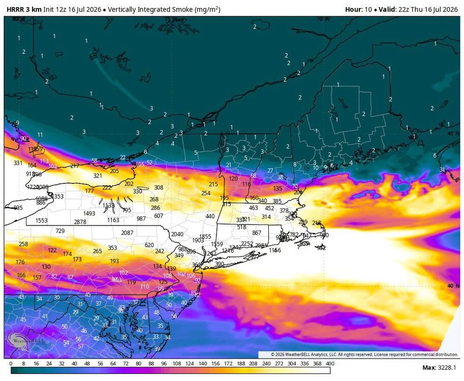
-
 far too incompetent to pull that off
 -
nest has popcorn firing to my west along the differential heating boundary between smoke and clear air
-
 The loop I just provided suggests we might be in trouble by 2 ...4pm
 -
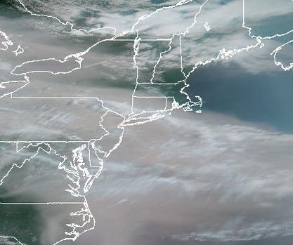
https://www.star.nesdis.noaa.gov/goes/sector_band.php?sat=G18§or=gwas&band=02&length=12&src=nav&refresh=true This projection offers a decent view as well
-
https://www.star.nesdis.noaa.gov/GOES/sector_band.php?sat=G18§or=gwas&band=GEOCOLOR&length=24
-
Have a cool breeze in Kearny right now. Making it feel tolerable minus the smell of smoke.
-
 I think eastern mass might be OK this afternoon. It might get a little hazy but nothing like yesterday.
 -
 If I squint on the GOES-W imagery, it looks like a surface based plume is pushing through southern VT.
 -
It must be a pretty serious issue given the length of the outage and no estimate for restoration.
-
Go go go !
-
 Awesome. Get out in it!
 -

2026-2027 Super El Nino
csnavywx replied to Stormchaserchuck1's topic in Weather Forecasting and Discussion
Yes, at first blush it's not a disaster for the SE. But last couple of strong Ninos makes it clear it may not be that cut and dry either. Either way, I'd bet on wet. -
Heavy heavy smoke is back ! YES!
-

2026-2027 Super El Nino
GaWx replied to Stormchaserchuck1's topic in Weather Forecasting and Discussion
Believable but will it actually happen? Nobody knows. Largest month to month warming on record is 0.85 (Jan ‘56). The largest warming on record in Aug is 0.61 (1988). Actually, the largest on record of any month July-Oct is only that 0.61. Here are the largest on record: 0.85 Jan 1956 0.84 June 1968 0.78 Mar 1951 0.73 Feb 1976 0.71 May 2026 0.68 Nov 2009 0.68 Mar 2000 0.66 May 1967 0.61 Aug 1988 0.61 Jan 1975 0.60 Oct 1991 0.60 Jan 1953 https://www.cpc.ncep.noaa.gov/data/indices/Rnino34.ascii.txt @Typhoon Tip -

2026 Mid-Atlantic Severe Storm General Discussion
midatlanticweather replied to Kmlwx's topic in Mid Atlantic
I asked Chat GPT - Here is what it thinks (LOL) Waste of time, but I could not resist! ------------------------- I've noticed the same thing this warm season, especially across the Mid-Atlantic. The NAM (both 12 km and 3 km Nest) has had a habit of looking terrible beyond about 6–12 hours for convective days, then suddenly "finding" storms in the final few runs. A few reasons: It's heavily driven by its own physics The NAM tends to overmix the boundary layer during the day. That lowers dewpoints too much. CAPE gets underdone and convective initiation is delayed or suppressed. Small errors explode in summertime July convection in Virginia often depends on: a leftover outflow boundary a weak differential heating zone a tiny vorticity maximum terrain circulations along the Blue Ridge If the model is off by 20 miles or an hour on any of those, the entire simulated radar looks different. Data assimilation doesn't capture morning boundaries well Once radar, satellite, surface observations, and morning soundings are ingested, the 6–12 hour forecasts improve dramatically because the model finally "knows" where the atmosphere actually is. The FV3-based CAMs have generally been outperforming it This year I've found: RRFS HRRR WoFS (short range) even the HRDPS at times have handled scattered convection better than the NAM Nest. The pattern we've been in is especially unfriendly We've had a lot of: weak northwest flow pulse convection little synoptic forcing abundant moisture That's almost the worst-case scenario for deterministic CAMs. The difference between "nothing" and "10 storms" can literally be one county's outflow boundary. For Loudoun County specifically The NAM has repeatedly shown this sequence: 24–36 hr: mostly dry 18 hr: isolated showers 12 hr: scattered storms 6 hr: widespread afternoon convection Reality: the 6-hour run ends up being closest. For your forecasting, I'd probably trust the NAM mainly for: temperature trends dewpoint trends low-level winds large-scale forcing ...and lean much more on the HRRR/RRFS for actual storm placement once you're inside about 18 hours. The other thing I've noticed this summer is that the ECMWF AI (AIFS) has often had a better "feel" for whether the day would end up active than the NAM did 24–48 hours out. It obviously can't tell you exactly where a cell will pop, but its broader convective signal has been surprisingly consistent. -
It’s the last picture before things went down. It was prior to my photo. It is uncertain when service will be restored.
-
It’s like when anemometers start breaking from too much wind.
-
Hands down the strongest I have smelled wildfire smoke in Chicago area. Glad I opted to do my run indoors this morning
-

Central PA Summer 2026 Discussion/Obs Thread
mahantango#1 replied to Voyager's topic in Upstate New York/Pennsylvania
Didn't coach ask you to suit up? -
Over 1400 at Hibbing MN, according to this post on our Lakes regional: https://www.americanwx.com/bb/topic/62756-july-2026-general-discussion/?do=findComment&comment=8112695
-
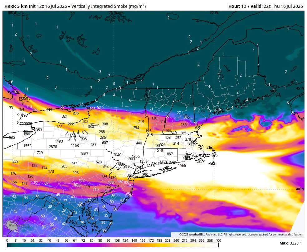
 While obviously not real-time empirical data like GOES, HRRR has smoke guidance you can see on Pivotal to give you an estimate of current and future placement of the band Looks like thick smoke enters most of MA / SNH early afternoon 17-20z
 -
All the PM monitors in Canada west of Buffalo went to “No Data”. Particulate level too high? Lol