All Activity
- Past hour
-
Where is that from? Weathermodels.com?
-

2026-2027 Record-breaking El Nino
bluewave replied to Stormchaserchuck1's topic in Weather Forecasting and Discussion
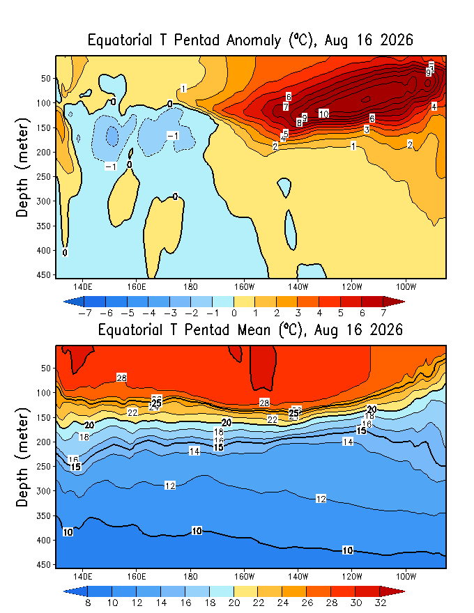
Starting to see +11 subsurface anomalies now.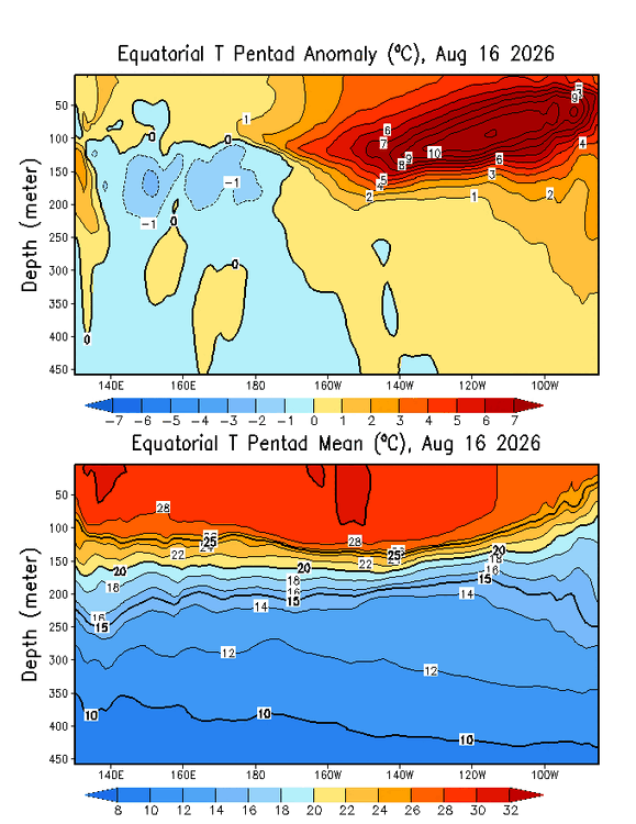
-
No thanks.
-
I’ve been enjoying seeing and experiencing some monsoon convection since I arrived in CO. Saw some good ones on the way to and inside the awesome Rocky Mtn State Park. Trail Ridge Road is so spectacular that it’s almost beyond words. It went from 80s in Boulder to as cold as 53 at 11,500-12,000 feet up! It was cold enough there for a light jacket, especially when considering the steady winds up there.
-
word
-

2026-2027 Record-breaking El Nino
mitchnick replied to Stormchaserchuck1's topic in Weather Forecasting and Discussion
It's been waxing and waning since February came into view. If you go to the actual Cfs2 site and check out the monthly forecasts, it's a little colder than what the TT site shows due to different time periods. https://www.cpc.ncep.noaa.gov/products/CFSv2/CFSv2seasonal.shtml -
This isn't a new thought, scientists have been looking for weather impacts from accelerated warming in the arctic for a while. One hypothesis is a weaker, wavier jetstream, amplifying and slowing the progression of weather patterns. As far as I am aware this hasn't been proven with studies on both sides. Not aware of any findings on baroclinic storms either. Note that increased moisture compensates for weaker temperature gradients in baroclinic storms through increased heat release from condensation in clouds. One weather effect that has been found is a northward shift in the jet stream and storm track.
- Today
-
30 wind and 5 tor for Delmarva
-
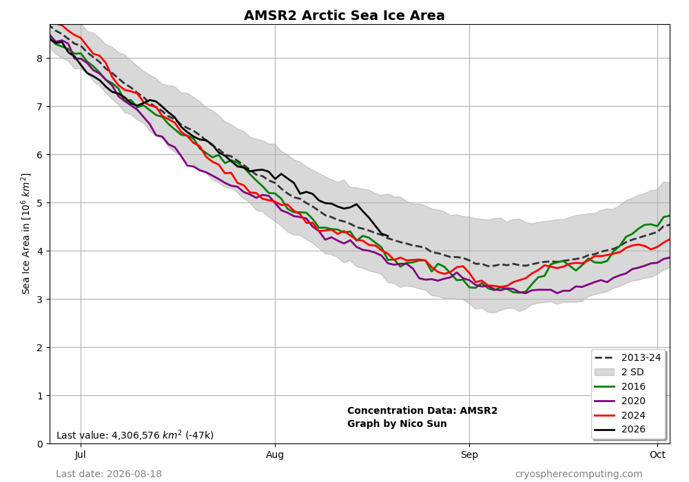
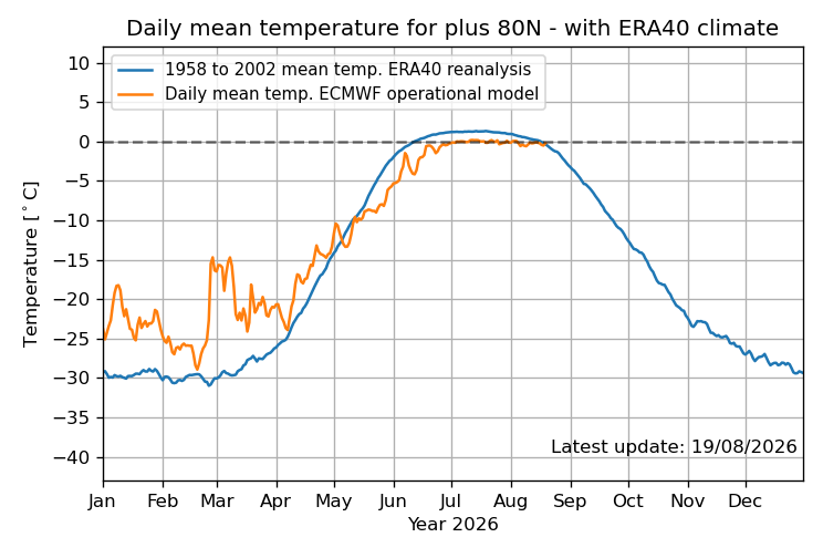
The Arctic sea ice area has fallen back to near the 2013-24 mean: Perhaps this is partially related to the temps at 80+N finally rising to NN recently:
-
06z Day 1 OTLK moved SLGT back west a bit to just west of BR... MRGL back west of i81 corridor
-
 online pharmacy discount code: worldwide pharmacy - legit online pharmacy
 -
instant cash advance no fee: CashBridgeConnect - paycheck advance online
-

Central PA Summer 2026 Discussion/Obs Thread
mahantango#1 replied to Voyager's topic in Upstate New York/Pennsylvania
-

Augdewst 2026: Summer's Last Stand
CoastalWx replied to Prismshine Productions's topic in New England
We knew. -
Central PA Summer 2026 Discussion/Obs Thread
mahantango#1 replied to Voyager's topic in Upstate New York/Pennsylvania
759 FXUS61 KCTP 200838 AFDCTP Area Forecast Discussion National Weather Service State College PA 438 AM EDT Thu Aug 20 2026 .WHAT HAS CHANGED... -- Changed Discussion -- * SPC upgraded southeast PA to a Slight Risk, highlighting potential for damaging winds and a tornado or two. * Increased rainfall totals today, including potential for a swath of 1-2"+ and an associated risk for isolated flooding. -- End Changed Discussion -- Hazardous Weather Outlook National Weather Service State College PA 449 AM EDT Thu Aug 20 2026 PAZ010>012-017>019-024>028-033>036-041-042-045-046-049>053-056>059- 063-064-210900- Elk-Cameron-Northern Clinton-Clearfield-Northern Centre- Southern Centre-Cambria-Blair-Huntingdon-Mifflin-Juniata-Somerset- Bedford-Fulton-Franklin-Northern Lycoming-Sullivan-Southern Clinton- Southern Lycoming-Union-Snyder-Montour-Northumberland-Columbia-Perry- Dauphin-Schuylkill-Lebanon-Cumberland-Adams- 449 AM EDT Thu Aug 20 2026 This Hazardous Weather Outlook is for central Pennsylvania. .DAY ONE...Today and tonight. Multiple rounds of moderate to heavy rainfall may lead to isolated instances of areal flooding today. .DAYS TWO THROUGH SEVEN...Friday through Wednesday. The probability for widespread hazardous weather is low. .SPOTTER INFORMATION STATEMENT... Spotter activation is not expected at this time. $$ Hazardous Weather Outlook National Weather Service State College PA 449 AM EDT Thu Aug 20 2026 PAZ065-066-210900- York-Lancaster- 449 AM EDT Thu Aug 20 2026 This Hazardous Weather Outlook is for central Pennsylvania. .DAY ONE...Today and tonight. Strong to severe thunderstorms this afternoon will be capable of producing very heavy rainfall, damaging winds, and a tornado or two. .DAYS TWO THROUGH SEVEN...Friday through Wednesday. The probability for widespread hazardous weather is low. .SPOTTER INFORMATION STATEMENT... Spotter activation is not expected at this time. $$ -

Augdewst 2026: Summer's Last Stand
ineedsnow replied to Prismshine Productions's topic in New England
0z EURO could have been interesting for the east coast.. EPS also but sooo far out.. -
Great... Flood watch extended
-
Is it a trend? Other models showing decent amount of rain, especially southern areas.
-
https://pharmtru.shop/# pharmacy websites
-

2026 Mid-Atlantic Severe Storm General Discussion
high risk replied to Kmlwx's topic in Mid Atlantic
Yeah, this is a pretty solid setup: good dynamics, good deep layer shear, and moderate instability. CAMs suggest that most areas north of DC are close to a lock to get storms, while there is a bit more uncertainty for areas south of DC.- 2,006 replies
-
- 1
-

-
- severe
- thunderstorms
- (and 7 more)
-
actual payday loan lenders online: CashBridge - best acceptance payday loans
-
https://northtrustpharmacy.shop/# canadian pharmacy meds reviews
-

2026 Atlantic Hurricane Season
Windspeed replied to Stormchaserchuck1's topic in Tropical Headquarters
The first wave the OP GFS had been persistently developing the past few days was lost on the most recent 00z run. No surprise, around 100-120 hrs, it gets mauled by 30-50 kt westerlies. The 2nd wave mentioned in the previous post hits the same wall around 200 hrs out. Something probably will hit a favorable pocket eventually, and perhaps the deep mind is seeing that, but the upper levels will have to chill out. Not sure how the AI models are handling those same modeled westerlies simulated on the GFS and ECMWF operationals at advanced hours. That being said, recent EURO runs have been flirting with the build of dominant 500 MB heights over the ECONUS and WATL around Labor Day. We'll see if one of the later AEWs can find its way under that ridge and a more favorable ULAC pocket amidst the upper level chaos. -
North Trust Pharmacy: thecanadianpharmacy - North Trust Pharmacy
-
online pharmacy [url=https://pharmtru.shop/#]no rx needed pharmacy[/url] overseas online pharmacy